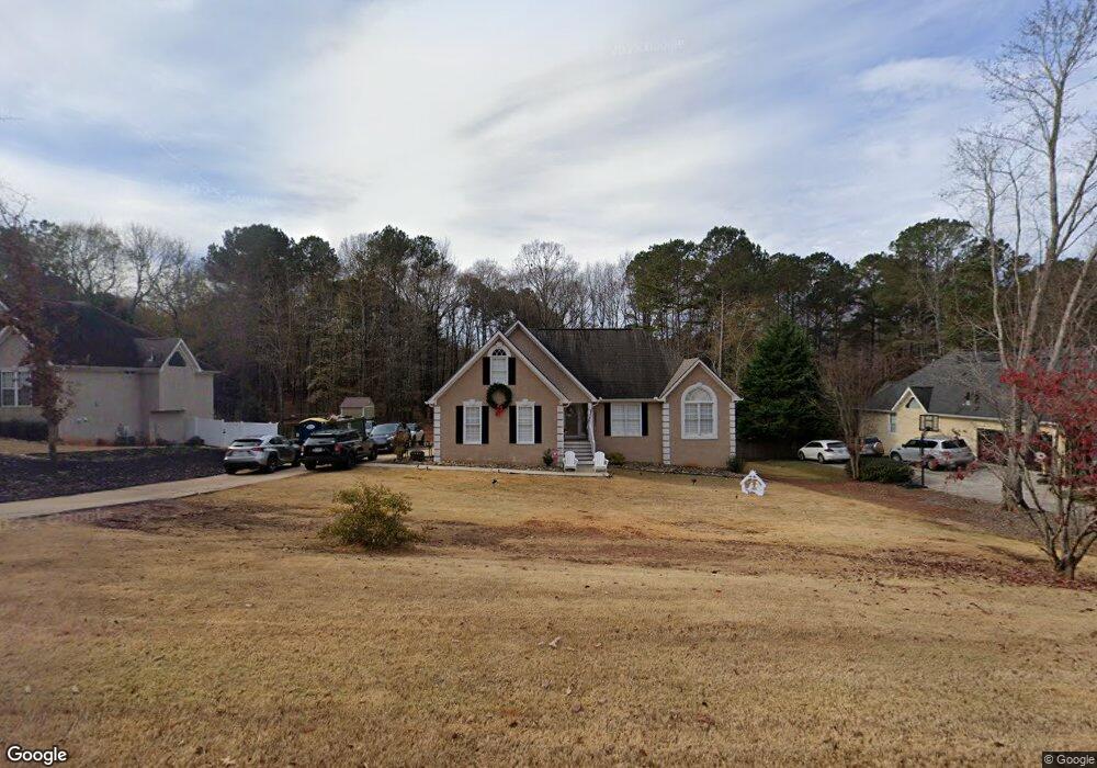
175 Brookstone Crest Newnan, GA 30265
Estimated Value: $446,000 - $516,000
4
Beds
2
Baths
2,086
Sq Ft
$229/Sq Ft
Est. Value
About This Home
This home is located at 175 Brookstone Crest, Newnan, GA 30265 and is currently estimated at $477,558, approximately $228 per square foot. 175 Brookstone Crest is a home located in Coweta County with nearby schools including Thomas Crossroads Elementary School, Arnall Middle School, and Northgate High School.
Ownership History
Date
Name
Owned For
Owner Type
Purchase Details
Closed on
Aug 25, 2015
Sold by
Jones David T
Bought by
Jones David T and Metcalf Jones Stacy
Current Estimated Value
Home Financials for this Owner
Home Financials are based on the most recent Mortgage that was taken out on this home.
Original Mortgage
$191,200
Outstanding Balance
$74,539
Interest Rate
4.02%
Mortgage Type
Commercial
Estimated Equity
$403,019
Purchase Details
Closed on
Jul 2, 1996
Bought by
David Lindsey Homes
Purchase Details
Closed on
Jun 28, 1995
Bought by
Regional Atlanta Dev
Purchase Details
Closed on
Dec 21, 1990
Bought by
Nall Harriet G
Purchase Details
Closed on
Apr 30, 1983
Bought by
Nall Hubert H
Create a Home Valuation Report for This Property
The Home Valuation Report is an in-depth analysis detailing your home's value as well as a comparison with similar homes in the area
Home Values in the Area
Average Home Value in this Area
Purchase History
| Date | Buyer | Sale Price | Title Company |
|---|---|---|---|
| Jones David T | -- | -- | |
| David Lindsey Homes | $356,300 | -- | |
| Regional Atlanta Dev | $269,700 | -- | |
| Nall Harriet G | -- | -- | |
| Nall Hubert H | -- | -- |
Source: Public Records
Mortgage History
| Date | Status | Borrower | Loan Amount |
|---|---|---|---|
| Open | Jones David T | $191,200 |
Source: Public Records
Tax History Compared to Growth
Tax History
| Year | Tax Paid | Tax Assessment Tax Assessment Total Assessment is a certain percentage of the fair market value that is determined by local assessors to be the total taxable value of land and additions on the property. | Land | Improvement |
|---|---|---|---|---|
| 2025 | $4,378 | $195,092 | $32,000 | $163,092 |
| 2024 | $4,113 | $181,776 | $28,000 | $153,776 |
| 2023 | $4,113 | $146,787 | $22,000 | $124,787 |
| 2022 | $3,356 | $140,930 | $22,000 | $118,930 |
| 2021 | $2,686 | $106,702 | $22,000 | $84,702 |
| 2020 | $2,503 | $99,184 | $22,000 | $77,184 |
| 2019 | $3,644 | $129,306 | $12,000 | $117,306 |
| 2018 | $3,651 | $129,306 | $12,000 | $117,306 |
| 2017 | $2,845 | $101,847 | $12,000 | $89,847 |
| 2016 | $2,813 | $101,847 | $12,000 | $89,847 |
| 2015 | $2,541 | $93,860 | $12,000 | $81,860 |
| 2014 | $2,091 | $93,860 | $12,000 | $81,860 |
Source: Public Records
Map
Nearby Homes
- 151 Brookstone Park
- LOT 5 Vaughn Rd
- 85 Holly Springs Rd
- 160 Maple Leaf Rd
- 14 Emory St
- 147 Crossroads Est Dr
- 10 Posey Ridge Ct
- 336 Ruth Dr
- 45 Meadow View Glen
- 185 Grand Jct
- 14 Culpepper Way
- 70 Barrington Farms Ct
- 30 Creekwood Dr
- 65 Barrington Ridge Ct
- 3771 Highway 34 E Unit TRACT2
- 3771 Highway 34 E Unit TRACT1
- 2462 Sharpsburg McCullum Rd
- 165 Bartlett Dr
- 495 George Coggin Rd
- 50 Barrington Grange Ct
- 165 Brookstone Crest
- 185 Brookstone Crescent
- 155 Brookstone Crest
- 195 Brookstone Crest
- 212 Brookstone Park
- 138 Brookstone Park
- 0 Brookstone Park Unit 7268857
- 148 Brookstone Park
- 145 Brookstone Crest
- 128 Brookstone Park
- 170 Brookstone Crest
- 180 Brookstone Crest
- 188 Brookstone Park
- 190 Brookstone Crest
- 160 Brookstone Crest
- 114 Brookstone Park
- 135 Brookstone Crest
- 200 Brookstone Crest
- 166 Brookstone Park Unit A-12
- 166 Brookstone Park