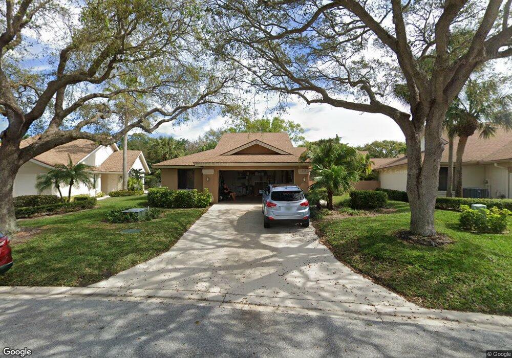
175 Cape Pointe Cir Jupiter, FL 33477
The Bluffs NeighborhoodEstimated Value: $880,000 - $1,268,000
3
Beds
2
Baths
1,889
Sq Ft
$555/Sq Ft
Est. Value
About This Home
This home is located at 175 Cape Pointe Cir, Jupiter, FL 33477 and is currently estimated at $1,048,964, approximately $555 per square foot. 175 Cape Pointe Cir is a home located in Palm Beach County with nearby schools including William T. Dwyer High School, Lighthouse Elementary School, and Beacon Cove Intermediate School.
Ownership History
Date
Name
Owned For
Owner Type
Purchase Details
Closed on
Sep 25, 2017
Sold by
Stauber Philip L and Stauber Amy
Bought by
Stauber Philip L and Stauber Amy
Current Estimated Value
Purchase Details
Closed on
Nov 9, 2001
Sold by
Lyons William C and Lyons Christine A
Bought by
Stauber Philip L
Home Financials for this Owner
Home Financials are based on the most recent Mortgage that was taken out on this home.
Original Mortgage
$190,000
Outstanding Balance
$65,254
Interest Rate
5.5%
Estimated Equity
$983,710
Create a Home Valuation Report for This Property
The Home Valuation Report is an in-depth analysis detailing your home's value as well as a comparison with similar homes in the area
Home Values in the Area
Average Home Value in this Area
Purchase History
| Date | Buyer | Sale Price | Title Company |
|---|---|---|---|
| Stauber Philip L | -- | Attorney | |
| Stauber Philip L | $237,500 | Gardens Title Inc |
Source: Public Records
Mortgage History
| Date | Status | Borrower | Loan Amount |
|---|---|---|---|
| Open | Stauber Philip L | $190,000 |
Source: Public Records
Tax History
| Year | Tax Paid | Tax Assessment Tax Assessment Total Assessment is a certain percentage of the fair market value that is determined by local assessors to be the total taxable value of land and additions on the property. | Land | Improvement |
|---|---|---|---|---|
| 2025 | $5,471 | $361,078 | -- | -- |
| 2024 | $5,471 | $350,902 | -- | -- |
| 2023 | $5,391 | $340,682 | $0 | $0 |
| 2022 | $5,386 | $330,759 | $0 | $0 |
| 2021 | $5,345 | $321,125 | $0 | $0 |
| 2020 | $5,341 | $316,691 | $0 | $0 |
| 2019 | $5,277 | $309,571 | $0 | $0 |
| 2018 | $5,017 | $303,799 | $0 | $0 |
| 2017 | $5,004 | $297,550 | $0 | $0 |
| 2016 | $5,015 | $291,430 | $0 | $0 |
| 2015 | $5,140 | $289,404 | $0 | $0 |
| 2014 | $5,211 | $287,107 | $0 | $0 |
Source: Public Records
Map
Nearby Homes
- 181 Cape Pointe Cir
- 125 Seashore Dr
- 246 Ridge Rd
- 238 River Park Dr
- 125 Cape Pointe Cir
- 126 Cape Pointe Cir
- 3071 30th Ct
- 3038 30th Ct
- 228 Ridge Rd
- 101 Cape Pointe Cir
- 216 Ridge Rd
- 119 Beach Summit Ct
- 316 River Edge Rd
- 125 Sand Pine Dr
- 401 Ocean Bluffs Blvd Unit 2050
- 401 Ocean Bluffs Blvd Unit 4020
- 438 River Edge Rd
- 2041 Staysail Ln
- 2028 Mainsail Cir
- 329 Leeward Dr
- 177 Cape Pointe Cir
- 173 Cape Pointe Cir
- 179 Cape Pointe Cir
- 312 Ridge Rd
- 310 Ridge Rd
- 314 Ridge Rd
- 171 Cape Pointe Cir
- 308 Ridge Rd
- 316 Ridge Rd
- 306 Ridge Rd
- 178 Cape Pointe Cir
- 170 Cape Pointe Cir
- 183 Cape Pointe Cir
- 322 Ridge Rd
- 304 Ridge Rd
- 326 Ridge Rd
- 182 Cape Pointe Cir
- 185 Cape Pointe Cir
- 328 Ridge Rd
- 302 Ridge Rd
Your Personal Tour Guide
Ask me questions while you tour the home.