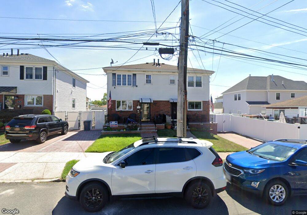
175 Cranford Ave Staten Island, NY 10306
Oakwood NeighborhoodEstimated Value: $692,223 - $755,000
3
Beds
2
Baths
1,224
Sq Ft
$587/Sq Ft
Est. Value
About This Home
This home is located at 175 Cranford Ave, Staten Island, NY 10306 and is currently estimated at $719,056, approximately $587 per square foot. 175 Cranford Ave is a home located in Richmond County with nearby schools including P.S. 23 Richmondtown, Myra S. Barnes Intermediate School 24, and New Dorp High School.
Ownership History
Date
Name
Owned For
Owner Type
Purchase Details
Closed on
Jun 1, 2007
Sold by
Paronich Rose Marie
Bought by
Rinaldo James C and Rinaldo Jaclyn
Current Estimated Value
Home Financials for this Owner
Home Financials are based on the most recent Mortgage that was taken out on this home.
Original Mortgage
$336,000
Outstanding Balance
$207,814
Interest Rate
6.39%
Mortgage Type
Purchase Money Mortgage
Estimated Equity
$511,242
Purchase Details
Closed on
May 23, 2007
Sold by
Paronich Paul and Paronich Ronald
Bought by
Paronich Rose Marie
Home Financials for this Owner
Home Financials are based on the most recent Mortgage that was taken out on this home.
Original Mortgage
$336,000
Outstanding Balance
$207,814
Interest Rate
6.39%
Mortgage Type
Purchase Money Mortgage
Estimated Equity
$511,242
Purchase Details
Closed on
Aug 7, 1997
Sold by
Paronich Rose Marie
Bought by
Paronich Paul and Paronich Ronald
Create a Home Valuation Report for This Property
The Home Valuation Report is an in-depth analysis detailing your home's value as well as a comparison with similar homes in the area
Home Values in the Area
Average Home Value in this Area
Purchase History
| Date | Buyer | Sale Price | Title Company |
|---|---|---|---|
| Rinaldo James C | $420,000 | None Available | |
| Paronich Rose Marie | -- | None Available | |
| Paronich Paul | -- | -- |
Source: Public Records
Mortgage History
| Date | Status | Borrower | Loan Amount |
|---|---|---|---|
| Open | Rinaldo James C | $336,000 |
Source: Public Records
Tax History Compared to Growth
Tax History
| Year | Tax Paid | Tax Assessment Tax Assessment Total Assessment is a certain percentage of the fair market value that is determined by local assessors to be the total taxable value of land and additions on the property. | Land | Improvement |
|---|---|---|---|---|
| 2025 | $5,774 | $36,360 | $8,015 | $28,345 |
| 2024 | $4,133 | $31,080 | $8,846 | $22,234 |
| 2023 | $5,492 | $28,440 | $7,611 | $20,829 |
| 2022 | $5,390 | $30,240 | $9,120 | $21,120 |
| 2021 | $5,436 | $31,860 | $9,120 | $22,740 |
| 2020 | $5,341 | $29,700 | $9,120 | $20,580 |
| 2019 | $4,962 | $30,720 | $9,120 | $21,600 |
| 2018 | $4,534 | $23,700 | $9,120 | $14,580 |
| 2017 | $4,610 | $24,087 | $8,594 | $15,493 |
| 2016 | $4,233 | $22,725 | $7,941 | $14,784 |
| 2015 | $3,863 | $22,725 | $7,633 | $15,092 |
| 2014 | $3,863 | $21,720 | $7,920 | $13,800 |
Source: Public Records
Map
Nearby Homes
- 126 Tysens Ln
- 50 Hitchcock Ave
- 194 Tysens Ln
- 32 Mobile Ave
- 55 Amber St
- 207 Park St
- 79 Ebony St
- 2889 Amboy Rd
- 124 Barbara St
- 61 Natick St
- 56 Wolverine St
- 175 Amber St
- 143 Wolverine St
- 43 Mace St
- 44 Thomas St
- 305 Tysens Ln Unit B
- 174 Barbara St
- 52 Francine Ct Unit A
- 52A Francine Ct Unit 80A
- 4 Penn Ave