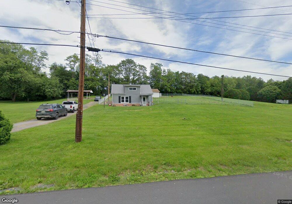
175 Loop Rd Lewistown, PA 17044
Estimated Value: $134,000 - $160,984
3
Beds
1
Bath
1,022
Sq Ft
$144/Sq Ft
Est. Value
About This Home
This home is located at 175 Loop Rd, Lewistown, PA 17044 and is currently estimated at $146,746, approximately $143 per square foot. 175 Loop Rd is a home located in Mifflin County with nearby schools including Strodes Mills Elementary School, Mifflin County Middle School, and Mifflin County Junior High School.
Ownership History
Date
Name
Owned For
Owner Type
Purchase Details
Closed on
Jul 20, 2023
Sold by
Wilson Daulton G
Bought by
Morder Jason
Current Estimated Value
Purchase Details
Closed on
Jan 9, 2017
Sold by
Estate Of Shirley M Stimely
Bought by
Wilson Daulton G
Purchase Details
Closed on
Nov 9, 2016
Sold by
Larson Nancy I
Bought by
Wilson Daulton G
Home Financials for this Owner
Home Financials are based on the most recent Mortgage that was taken out on this home.
Original Mortgage
$50,000
Interest Rate
3.47%
Mortgage Type
New Conventional
Purchase Details
Closed on
Oct 15, 1991
Bought by
Stimely Shirley M
Create a Home Valuation Report for This Property
The Home Valuation Report is an in-depth analysis detailing your home's value as well as a comparison with similar homes in the area
Home Values in the Area
Average Home Value in this Area
Purchase History
| Date | Buyer | Sale Price | Title Company |
|---|---|---|---|
| Morder Jason | $63,000 | -- | |
| Wilson Daulton G | $2,000 | None Available | |
| Wilson Daulton G | $50,000 | None Available | |
| Stimely Shirley M | -- | -- |
Source: Public Records
Mortgage History
| Date | Status | Borrower | Loan Amount |
|---|---|---|---|
| Previous Owner | Wilson Daulton G | $50,000 |
Source: Public Records
Tax History Compared to Growth
Tax History
| Year | Tax Paid | Tax Assessment Tax Assessment Total Assessment is a certain percentage of the fair market value that is determined by local assessors to be the total taxable value of land and additions on the property. | Land | Improvement |
|---|---|---|---|---|
| 2025 | $1,542 | $24,300 | $12,450 | $11,850 |
| 2024 | $1,542 | $24,300 | $12,450 | $11,850 |
| 2023 | $1,542 | $24,300 | $12,450 | $11,850 |
| 2022 | $1,494 | $24,300 | $12,450 | $11,850 |
| 2021 | $1,494 | $24,300 | $12,450 | $11,850 |
| 2020 | $1,506 | $24,500 | $12,450 | $12,050 |
| 2019 | $1,480 | $24,500 | $12,450 | $12,050 |
| 2018 | $1,485 | $24,500 | $12,450 | $12,050 |
| 2017 | $1,485 | $24,500 | $12,450 | $12,050 |
| 2016 | $1,551 | $26,350 | $14,300 | $12,050 |
| 2015 | -- | $14,300 | $14,300 | $0 |
| 2012 | -- | $26,350 | $14,300 | $12,050 |
Source: Public Records
Map
Nearby Homes
- 9487 Us Highway 522 S
- 67 Airport Hill Rd
- 1470 Middle Rd
- 65 Hillside Dr
- 131 Snooks Hill Rd
- 18 Maple Ave
- 924 W 6th St
- 4755 State Route 103 N
- 817 W 6th St
- 705-707 W 6th St
- 162 Birch Dr
- 622 W 5th St
- 616 W 5th St
- 620 W 6th St
- 78 Brannon Ln
- 105 Grove Ave
- 1810 Lockport Rd
- 41 Aspen Dr Unit 3
- 409 W 5th St
- Lot 1 Woods Ln