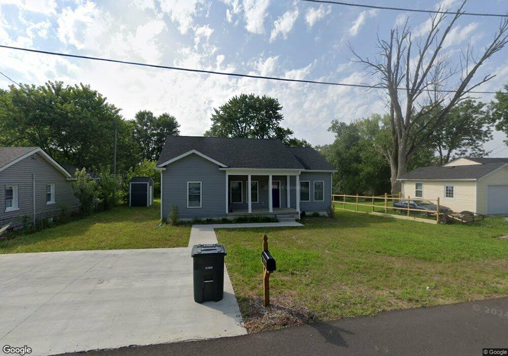
175 Maple Dr Charlestown, IN 47111
Estimated Value: $227,453
3
Beds
1
Bath
1,430
Sq Ft
$159/Sq Ft
Est. Value
About This Home
This home is located at 175 Maple Dr, Charlestown, IN 47111 and is currently estimated at $227,453, approximately $159 per square foot. 175 Maple Dr is a home located in Clark County with nearby schools including Jonathan Jennings Elementary School, Charlestown Senior High School, and St. Michael School.
Ownership History
Date
Name
Owned For
Owner Type
Purchase Details
Closed on
Feb 9, 2024
Sold by
Habitat For Humanity Clark & Floyd India
Bought by
Irvin Aerion
Current Estimated Value
Purchase Details
Closed on
Jun 10, 2021
Sold by
Charlestown City Of
Bought by
Habitat For Hum Clark
Purchase Details
Closed on
Jan 20, 2021
Sold by
Green Tree 2008 Mh 1
Bought by
Charlestown City Of
Purchase Details
Closed on
Jan 16, 2020
Sold by
Simms Frances L Est
Bought by
Wells Fargo Bank Na
Purchase Details
Closed on
Sep 18, 2018
Sold by
Flanagan Malissa and Simms Mary
Bought by
Flanagan Malissa
Purchase Details
Closed on
Jul 25, 2018
Sold by
Simms Frances L
Bought by
Flanagan Malissa and Haudeck Tina
Create a Home Valuation Report for This Property
The Home Valuation Report is an in-depth analysis detailing your home's value as well as a comparison with similar homes in the area
Home Values in the Area
Average Home Value in this Area
Purchase History
| Date | Buyer | Sale Price | Title Company |
|---|---|---|---|
| Irvin Aerion | $215,000 | Momentum Title Agency | |
| Habitat For Hum Clark | -- | None Available | |
| Charlestown City Of | -- | None Available | |
| Wells Fargo Bank Na | $31,704 | None Available | |
| Flanagan Malissa | -- | -- | |
| Flanagan Malissa | $50,000 | -- | |
| Flanagan Malissa | -- | -- |
Source: Public Records
Tax History Compared to Growth
Tax History
| Year | Tax Paid | Tax Assessment Tax Assessment Total Assessment is a certain percentage of the fair market value that is determined by local assessors to be the total taxable value of land and additions on the property. | Land | Improvement |
|---|---|---|---|---|
| 2024 | -- | $0 | $0 | $0 |
| 2023 | -- | $0 | $0 | $0 |
| 2022 | $0 | $0 | $0 | $0 |
| 2021 | $1,096 | $0 | $0 | $0 |
| 2020 | $1,096 | $135,800 | $19,000 | $116,800 |
| 2019 | $881 | $123,600 | $13,600 | $110,000 |
| 2018 | $1,124 | $134,600 | $13,600 | $121,000 |
| 2017 | $754 | $115,100 | $13,600 | $101,500 |
| 2016 | $754 | $117,900 | $13,600 | $104,300 |
| 2014 | $674 | $109,000 | $13,600 | $95,400 |
| 2013 | -- | $83,500 | $13,600 | $69,900 |
Source: Public Records
Map
Nearby Homes
- The Eston (Slab) Plan at Aspen Meadows
- The Harper (Slab) Plan at Aspen Meadows
- The Madelynn (Slab) Plan at Aspen Meadows
- 228 Drive-In (Lot #1) Ct
- 226 Drive-In (Lot #2) Ct
- 102 Lisa Ln
- 222 Drive-In (Lot #4) Ct
- 101 Jackson Way
- 179 5th St
- BERKSHIRE Plan at Villas of Springville Manor
- AUBURN Plan at Villas of Springville Manor
- 339 Bohart Ln
- 432 Springville Dr
- 435 Springville Dr
- 430 Springville Dr
- 434 Springville Dr
- 2080 Edgewood Dr
- 129 Broadmoor Ave
- 8410 Woodland Rd
- 1440 Lindsey St