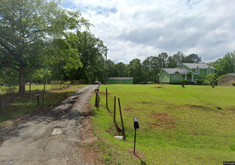
175 Moreland Rd Forsyth, GA 31029
Estimated Value: $239,282 - $252,000
4
Beds
2
Baths
1,825
Sq Ft
$134/Sq Ft
Est. Value
About This Home
This home is located at 175 Moreland Rd, Forsyth, GA 31029 and is currently estimated at $245,071, approximately $134 per square foot. 175 Moreland Rd is a home located in Monroe County with nearby schools including Samuel E. Hubbard Elementary School and Mary Persons High School.
Ownership History
Date
Name
Owned For
Owner Type
Purchase Details
Closed on
Nov 13, 2018
Sold by
Reno Matt
Bought by
Powell Roger
Current Estimated Value
Home Financials for this Owner
Home Financials are based on the most recent Mortgage that was taken out on this home.
Original Mortgage
$130,492
Outstanding Balance
$113,801
Interest Rate
4.8%
Mortgage Type
VA
Estimated Equity
$131,270
Purchase Details
Closed on
Jun 5, 2018
Sold by
Gresham Robert Gene
Bought by
Reno Matthew
Purchase Details
Closed on
Sep 6, 2011
Sold by
Gresham Dorothy Ann
Bought by
Head Pauline and Gresham Willie Ed
Purchase Details
Closed on
Sep 15, 1998
Sold by
Grisham Robert Gene
Bought by
Gresham Robert Gene
Purchase Details
Closed on
Feb 11, 1992
Sold by
Grisham Willie
Bought by
Grisham Robert Gene
Create a Home Valuation Report for This Property
The Home Valuation Report is an in-depth analysis detailing your home's value as well as a comparison with similar homes in the area
Home Values in the Area
Average Home Value in this Area
Purchase History
| Date | Buyer | Sale Price | Title Company |
|---|---|---|---|
| Powell Roger | $132,900 | -- | |
| Reno Matthew | $60,000 | -- | |
| Head Pauline | -- | -- | |
| Gresham Robert Gene | -- | -- | |
| Grisham Robert Gene | -- | -- |
Source: Public Records
Mortgage History
| Date | Status | Borrower | Loan Amount |
|---|---|---|---|
| Open | Powell Roger | $130,492 |
Source: Public Records
Tax History Compared to Growth
Tax History
| Year | Tax Paid | Tax Assessment Tax Assessment Total Assessment is a certain percentage of the fair market value that is determined by local assessors to be the total taxable value of land and additions on the property. | Land | Improvement |
|---|---|---|---|---|
| 2024 | $1,125 | $60,840 | $4,080 | $56,760 |
| 2023 | $1,125 | $52,200 | $4,080 | $48,120 |
| 2022 | $1,088 | $52,200 | $4,080 | $48,120 |
| 2021 | $1,127 | $52,200 | $4,080 | $48,120 |
| 2020 | $1,155 | $52,200 | $4,080 | $48,120 |
| 2019 | $1,164 | $52,200 | $4,080 | $48,120 |
| 2018 | $1,215 | $41,840 | $4,080 | $37,760 |
| 2017 | $1,216 | $41,840 | $4,080 | $37,760 |
| 2016 | $1,156 | $41,840 | $4,080 | $37,760 |
| 2015 | $1,096 | $41,840 | $4,080 | $37,760 |
| 2014 | $1,057 | $41,840 | $4,080 | $37,760 |
Source: Public Records
Map
Nearby Homes
- 289 Willis Wilder Dr
- 95 Mitchell Rd
- 309 Willis Wilder Dr
- 319 Willis Wilder Dr
- 11 Dew Place
- 120 Willis Wilder Dr
- 60 Dew Place
- 62 Washington Dr
- 451 Georgia 83
- 299 Willis Wilder Dr
- 292 Martin Luther King Junior Dr
- 507 W Main St
- 556 Constitution Dr
- 333 W Main St
- 119 Country Club Dr
- 71 S Lee St
- 71 S South Lee St
- 101 E Chambers St
- 0 Hopewell Rd Unit 24477788
- 243 Copper Crossing
- 153 Moreland Rd
- 195 Moreland Rd
- 321 Moreland Rd
- 115 Moreland Rd
- 115 Moreland Rd Unit 4172 WEST OAK DR
- 225 Moreland Rd
- 237 Moreland Rd
- 99 Moreland Rd
- 77 Moreland Rd
- 0 Moreland Rd Unit Lots 1-3 8490082
- Lots1-3 Moreland Rd Unit 1-3
- 285 Moreland Rd
- 480 Old Brent Rd
- 470 Old Brent Rd
- 450 Old Brent Rd
- 118 Moreland Rd
- 455 Old Brent Rd
- 415 Old Brent Rd
- 558 Old Brent Rd
- 0 Old Brent Rd Unit 10469308