Estimated Value: $166,000 - $294,000
--
Bed
1
Bath
3,829
Sq Ft
$55/Sq Ft
Est. Value
About This Home
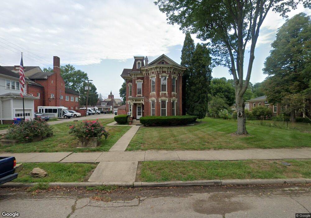
This home is located at 175 N Mulberry St, Logan, OH 43138 and is currently estimated at $209,193, approximately $54 per square foot. 175 N Mulberry St is a home with nearby schools including Central Elementary School, St. John the Evangelist School, and Logan Christian School.
Ownership History
Date
Name
Owned For
Owner Type
Purchase Details
Closed on
Feb 19, 2025
Sold by
Mulberry Logan Holdings Llc
Bought by
Hannah James
Current Estimated Value
Purchase Details
Closed on
Jul 27, 2018
Sold by
Krasnosky Dennis Allen and Krasnosky Diane Louise
Bought by
Archaeological Conservancy
Purchase Details
Closed on
Jan 23, 2018
Sold by
Henniger Bill
Bought by
Mulberry Logan Holdings Llc
Purchase Details
Closed on
Jun 29, 2016
Sold by
Hockman Beverly Jo
Bought by
Henniger Bill
Create a Home Valuation Report for This Property
The Home Valuation Report is an in-depth analysis detailing your home's value as well as a comparison with similar homes in the area
Home Values in the Area
Average Home Value in this Area
Purchase History
| Date | Buyer | Sale Price | Title Company |
|---|---|---|---|
| Hannah James | $162,000 | Northwest Select Title Agency | |
| Archaeological Conservancy | $30,500 | None Available | |
| Mulberry Logan Holdings Llc | -- | None Available | |
| Henniger Bill | $154,000 | None Available |
Source: Public Records
Tax History Compared to Growth
Tax History
| Year | Tax Paid | Tax Assessment Tax Assessment Total Assessment is a certain percentage of the fair market value that is determined by local assessors to be the total taxable value of land and additions on the property. | Land | Improvement |
|---|---|---|---|---|
| 2024 | $3,034 | $75,170 | $22,480 | $52,690 |
| 2023 | $3,034 | $75,170 | $22,480 | $52,690 |
| 2022 | $3,039 | $75,170 | $22,480 | $52,690 |
| 2021 | $2,206 | $51,890 | $17,690 | $34,200 |
| 2020 | $2,207 | $51,890 | $17,690 | $34,200 |
| 2019 | $2,208 | $51,890 | $17,690 | $34,200 |
| 2018 | $1,870 | $44,740 | $15,100 | $29,640 |
| 2017 | $1,761 | $44,740 | $15,100 | $29,640 |
| 2016 | $1,748 | $44,740 | $15,100 | $29,640 |
| 2015 | $1,630 | $40,250 | $14,000 | $26,250 |
| 2014 | $1,633 | $40,250 | $14,000 | $26,250 |
| 2013 | $1,639 | $40,250 | $14,000 | $26,250 |
Source: Public Records
Map
Nearby Homes
- State Route 328
- 582 N Walnut St
- 90 S Culver St
- 288 Walnut Dr
- 687 N Walnut St
- 67 W Front St
- 733 Walnut Dr
- 385 W Main St
- 335 Vine St
- 171 Warner Ave
- 571 E Main St
- 707 Edgehill Dr
- 862 Walnut Dowler Rd
- 586 E Main St
- 347 Belva Ct
- 28583 Hawthorne Way
- 150 Wood St
- 165 N Homer Ave
- 597 Henrietta Ave
- 605 Glenwood Dr
- 143 N Mulberry St
- 171 N Mulberry St
- 207 N Mulberry St
- 186 Midland Place
- 60 E Hunter St
- 198 Midland Place
- 66 E Hunter St
- 200 Midland Place
- 245 N Mulberry St
- 172 N Mulberry St
- 146 N Mulberry St
- 100 E Hunter St
- 238 N Mulberry St
- 253 N Mulberry St
- 253 N Mulberry St Unit 2
- 175 Midland Place
- 137 Midland Place
- 197 Midland Place
- 128 E Hunter St
- 264 Midland Place