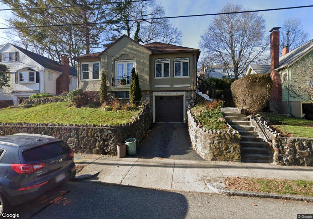
175 Newport St Arlington, MA 02476
Arlington Center NeighborhoodEstimated Value: $919,452 - $1,058,000
2
Beds
1
Bath
1,091
Sq Ft
$919/Sq Ft
Est. Value
About This Home
This home is located at 175 Newport St, Arlington, MA 02476 and is currently estimated at $1,002,363, approximately $918 per square foot. 175 Newport St is a home located in Middlesex County with nearby schools including Brackett Elementary School, Ottoson Middle School, and Arlington High School.
Ownership History
Date
Name
Owned For
Owner Type
Purchase Details
Closed on
Oct 30, 2014
Sold by
Doyle Karen B
Bought by
Karen B Doyle Ret
Current Estimated Value
Purchase Details
Closed on
Sep 11, 2009
Sold by
Powers Robert and Powers Maureen
Bought by
Doyle Karen
Purchase Details
Closed on
Feb 3, 2005
Sold by
Bourget Marguerite E
Bought by
Powers Maureen and Powers Robert
Home Financials for this Owner
Home Financials are based on the most recent Mortgage that was taken out on this home.
Original Mortgage
$337,500
Interest Rate
5.77%
Mortgage Type
Purchase Money Mortgage
Create a Home Valuation Report for This Property
The Home Valuation Report is an in-depth analysis detailing your home's value as well as a comparison with similar homes in the area
Home Values in the Area
Average Home Value in this Area
Purchase History
| Date | Buyer | Sale Price | Title Company |
|---|---|---|---|
| Karen B Doyle Ret | -- | -- | |
| Doyle Karen | $421,533 | -- | |
| Powers Maureen | $375,000 | -- |
Source: Public Records
Mortgage History
| Date | Status | Borrower | Loan Amount |
|---|---|---|---|
| Previous Owner | Powers Maureen | $337,500 |
Source: Public Records
Tax History Compared to Growth
Tax History
| Year | Tax Paid | Tax Assessment Tax Assessment Total Assessment is a certain percentage of the fair market value that is determined by local assessors to be the total taxable value of land and additions on the property. | Land | Improvement |
|---|---|---|---|---|
| 2025 | $8,988 | $834,500 | $552,000 | $282,500 |
| 2024 | $8,215 | $775,700 | $529,900 | $245,800 |
| 2023 | $8,022 | $715,600 | $463,700 | $251,900 |
| 2022 | $7,782 | $681,400 | $441,600 | $239,800 |
| 2021 | $7,530 | $664,000 | $441,600 | $222,400 |
| 2020 | $7,344 | $664,000 | $441,600 | $222,400 |
| 2019 | $7,088 | $629,500 | $414,000 | $215,500 |
| 2018 | $6,765 | $557,700 | $342,200 | $215,500 |
| 2017 | $6,658 | $530,100 | $314,600 | $215,500 |
| 2016 | $6,432 | $502,500 | $287,000 | $215,500 |
| 2015 | $6,382 | $471,000 | $281,500 | $189,500 |
Source: Public Records
Map
Nearby Homes
- 789 Concord Turnpike
- 39 Newport St
- 53 Highland Ave
- 37 Fountain Rd Unit 2
- 37 Fountain Rd
- 10 Plymouth St Unit 10
- 36 Churchill Ave Unit 1
- 995 Massachusetts Ave Unit 404
- 1025 Massachusetts Ave Unit 204
- 204 Plan at Majestic Mill Brook
- 1025 Massachusetts Ave Unit 404
- 1025 Massachusetts Ave Unit 506
- 1025 Massachusetts Ave Unit 401
- 1025 Massachusetts Ave Unit 210
- 1025 Massachusetts Ave Unit 402
- 1025 Massachusetts Ave Unit 308
- 1025 Massachusetts Ave Unit 411
- 1025 Massachusetts Ave Unit 313
- 1025 Massachusetts Ave Unit 304
- 1025 Massachusetts Ave Unit 414
- 173 Newport St
- 174 Newport St
- 16 Eastern Ave
- 174 Scituate St
- 177 Newport St
- 20 Eastern Ave
- 178 Scituate St
- 176 Newport St
- 170 Newport St
- 180 Scituate St
- 24 Eastern Ave
- 178 Newport St
- 179 Newport St
- 8 Eastern Ave
- 182 Newport St
- 182 Scituate St
- 259 Highland Ave
- 17 Eastern Ave
- 263 Highland Ave
- 181 Newport St