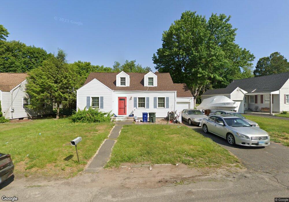
175 Pilgrim Rd Bridgeport, CT 06610
North Bridgeport NeighborhoodEstimated Value: $387,000 - $437,000
4
Beds
2
Baths
1,580
Sq Ft
$268/Sq Ft
Est. Value
About This Home
This home is located at 175 Pilgrim Rd, Bridgeport, CT 06610 and is currently estimated at $422,900, approximately $267 per square foot. 175 Pilgrim Rd is a home located in Fairfield County with nearby schools including Hooker School and Harding High School.
Ownership History
Date
Name
Owned For
Owner Type
Purchase Details
Closed on
May 4, 1998
Sold by
Ulreich James A and Peloso Tina
Bought by
Allen Thomas and Allen Cindeletha
Current Estimated Value
Create a Home Valuation Report for This Property
The Home Valuation Report is an in-depth analysis detailing your home's value as well as a comparison with similar homes in the area
Home Values in the Area
Average Home Value in this Area
Purchase History
| Date | Buyer | Sale Price | Title Company |
|---|---|---|---|
| Allen Thomas | $111,240 | -- | |
| Allen Thomas | $111,240 | -- |
Source: Public Records
Mortgage History
| Date | Status | Borrower | Loan Amount |
|---|---|---|---|
| Open | Allen Thomas | $242,000 | |
| Closed | Allen Thomas | $216,000 | |
| Closed | Allen Thomas | $183,600 | |
| Closed | Allen Thomas | $154,800 |
Source: Public Records
Tax History
| Year | Tax Paid | Tax Assessment Tax Assessment Total Assessment is a certain percentage of the fair market value that is determined by local assessors to be the total taxable value of land and additions on the property. | Land | Improvement |
|---|---|---|---|---|
| 2025 | $6,759 | $155,550 | $65,140 | $90,410 |
| 2024 | $6,759 | $155,550 | $65,140 | $90,410 |
| 2023 | $6,759 | $155,550 | $65,140 | $90,410 |
| 2022 | $6,759 | $155,550 | $65,140 | $90,410 |
| 2021 | $6,759 | $155,550 | $65,140 | $90,410 |
| 2020 | $6,711 | $124,310 | $53,440 | $70,870 |
| 2019 | $6,711 | $124,310 | $53,440 | $70,870 |
| 2018 | $6,759 | $124,310 | $53,440 | $70,870 |
| 2017 | $6,759 | $124,310 | $53,440 | $70,870 |
| 2016 | $6,759 | $124,310 | $53,440 | $70,870 |
| 2015 | $6,284 | $148,900 | $52,230 | $96,670 |
| 2014 | $6,284 | $148,900 | $52,230 | $96,670 |
Source: Public Records
Map
Nearby Homes
- 119 Jennings Ave
- 120 Huntington Turnpike Unit 202
- 211 Louisiana Ave Unit D
- 11 Nob Hill Cir
- 132 Virginia Ave Unit 132
- 3699 Broadbridge Ave Unit 101
- 186 Louisiana Ave Unit D
- 261 Pennsylvania Ave
- 154 Virginia Ave Unit B
- 33 Louisiana Ave Unit 35
- 285 Hillcrest Rd
- 250 Dayton Rd
- 207 Hillcrest Rd
- 156 Dayton Rd
- 11 Knollcrest Dr
- 72 Broadmere Rd
- 74 Hollywood Ave
- 563 Pearl Harbor St
- 2100-2102 E Main St
- 2092-2096 E Main St
- 163 Pilgrim Rd
- 180 Pilgrim Rd
- 170 Pilgrim Rd
- 149 Pilgrim Rd
- 193 Pilgrim Rd
- 150 Pilgrim Rd
- 188 Pilgrim Rd
- 209 Pilgrim Rd
- 133 Pilgrim Rd
- 140 Pilgrim Rd
- 198 Pilgrim Rd
- 60 Roger Williams Rd
- 210 Pilgrim Rd
- 309 Nutmeg Rd
- 325 Nutmeg Rd
- 325 Nutmeg Rd Unit 18
- 111 Pilgrim Rd
- 48 Roger Williams Rd
- 34 Roger Williams Rd
Your Personal Tour Guide
Ask me questions while you tour the home.