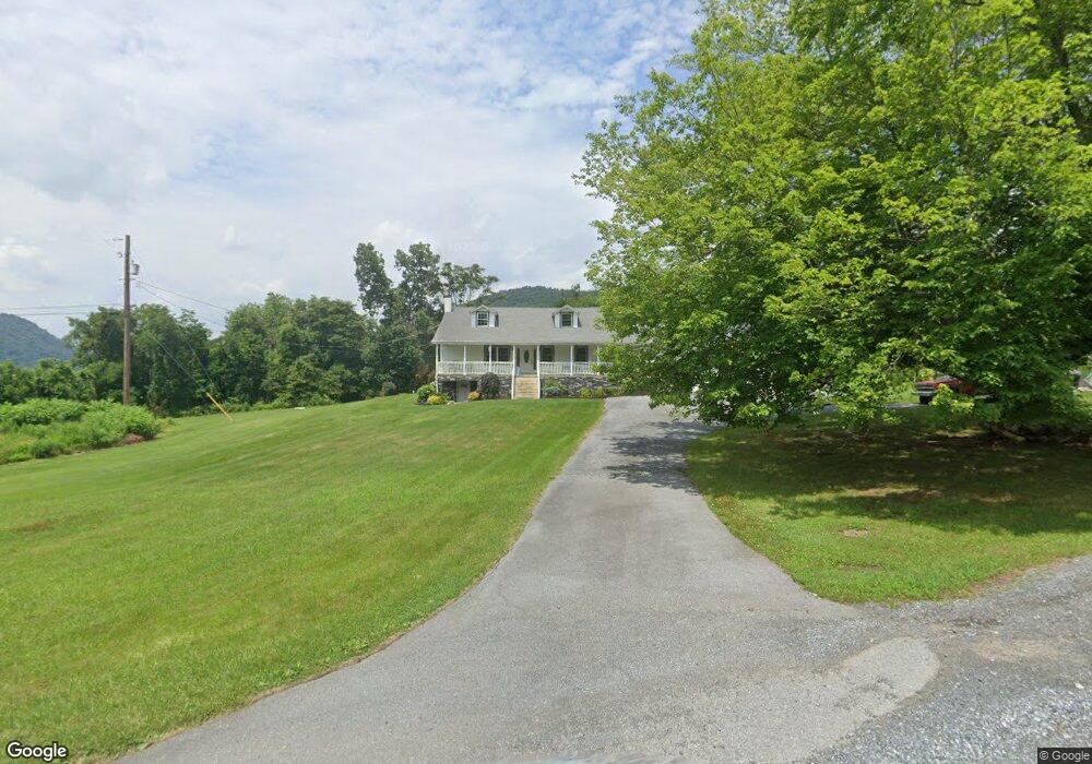
1750 Landis Rd Dauphin, PA 17018
Estimated Value: $210,000 - $364,000
4
Beds
1
Bath
1,724
Sq Ft
$171/Sq Ft
Est. Value
About This Home
This home is located at 1750 Landis Rd, Dauphin, PA 17018 and is currently estimated at $294,557, approximately $170 per square foot. 1750 Landis Rd is a home located in Dauphin County with nearby schools including Middle Paxton Elementary School, Central Dauphin Middle School, and Central Dauphin Senior High School.
Ownership History
Date
Name
Owned For
Owner Type
Purchase Details
Closed on
Oct 16, 2024
Sold by
Vogelsong Richard C and Vogelsong Kristie S
Bought by
Vogelsong Richard C
Current Estimated Value
Home Financials for this Owner
Home Financials are based on the most recent Mortgage that was taken out on this home.
Original Mortgage
$250,000
Interest Rate
6.91%
Mortgage Type
New Conventional
Purchase Details
Closed on
Oct 25, 2021
Sold by
Vogelsong Richard and Vogelsong Richard C
Bought by
Vogelsong Richard C and Vogelsong Kristie S
Purchase Details
Closed on
Dec 7, 2016
Sold by
Landis Ona E and Murphy Donna S
Bought by
Vogelsong Richard
Create a Home Valuation Report for This Property
The Home Valuation Report is an in-depth analysis detailing your home's value as well as a comparison with similar homes in the area
Home Values in the Area
Average Home Value in this Area
Purchase History
| Date | Buyer | Sale Price | Title Company |
|---|---|---|---|
| Vogelsong Richard C | -- | None Listed On Document | |
| Vogelsong Richard C | -- | None Available | |
| Vogelsong Richard | $107,000 | None Available |
Source: Public Records
Mortgage History
| Date | Status | Borrower | Loan Amount |
|---|---|---|---|
| Previous Owner | Vogelsong Richard C | $250,000 |
Source: Public Records
Tax History Compared to Growth
Tax History
| Year | Tax Paid | Tax Assessment Tax Assessment Total Assessment is a certain percentage of the fair market value that is determined by local assessors to be the total taxable value of land and additions on the property. | Land | Improvement |
|---|---|---|---|---|
| 2025 | $3,303 | $126,100 | $25,800 | $100,300 |
| 2024 | $3,113 | $126,100 | $25,800 | $100,300 |
| 2023 | $3,113 | $126,100 | $25,800 | $100,300 |
| 2022 | $3,113 | $126,100 | $25,800 | $100,300 |
| 2021 | $3,037 | $126,100 | $25,800 | $100,300 |
| 2020 | $3,000 | $126,100 | $25,800 | $100,300 |
| 2019 | $2,498 | $105,000 | $25,800 | $79,200 |
| 2018 | $2,451 | $105,000 | $25,800 | $79,200 |
| 2017 | $2,357 | $105,000 | $25,800 | $79,200 |
| 2016 | $0 | $105,000 | $25,800 | $79,200 |
| 2015 | -- | $105,000 | $25,800 | $79,200 |
| 2014 | -- | $105,000 | $25,800 | $79,200 |
Source: Public Records
Map
Nearby Homes
- 1517 Red Hill Rd
- 1217 Red Hill Rd
- 609 Schoolhouse Rd
- 0 Unit WP001
- 0 Inn Rd
- 10 Susquenita Hill Rd
- 735 Hunt Meadow Dr
- 1028 Kathryn Ave
- 68 S Main St
- 226 N Market St
- 125 N Market St
- 1014 State Rd
- 15 Locust St
- 105 Ann St
- 115 N High St
- 422 N High St
- 14 Center St
- 1126 N Market St
- 901 Gap View Rd
- 125 Cherry St
- 1752 Landis Rd
- 1530 Buck Run Rd
- 1864 Riverview Route 22 322
- 00 Mountain Rd
- 1650 Mountain Rd
- 1854 Towpath Rd
- 1644 Mountain Rd
- 1906 Towpath Rd
- 1906 Towpath Rd
- 1701 Red Hill Rd
- 1741 Mountain Rd
- 1846 Towpath Rd
- 1731 Mountain Rd
- 1721 Mountain Rd
- 1415 Hillside Ln
- 1691 Mountain Rd
- 1701 Mountain Rd
- 1701 Mountain Rd
- 1711 Mountain Rd
- 1410 Hillside Ln