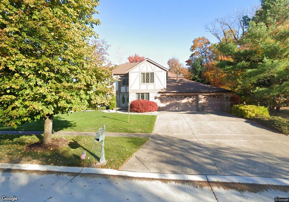
17534 Deer Ridge Cir Strongsville, OH 44136
Estimated Value: $471,000 - $539,000
4
Beds
3
Baths
3,034
Sq Ft
$164/Sq Ft
Est. Value
About This Home
This home is located at 17534 Deer Ridge Cir, Strongsville, OH 44136 and is currently estimated at $498,805, approximately $164 per square foot. 17534 Deer Ridge Cir is a home located in Cuyahoga County with nearby schools including Strongsville High School and Saint Ambrose Catholic School.
Ownership History
Date
Name
Owned For
Owner Type
Purchase Details
Closed on
Dec 28, 2002
Sold by
Maracz Michael J and Maracz Patricia M
Bought by
Dailey John Joseph
Current Estimated Value
Home Financials for this Owner
Home Financials are based on the most recent Mortgage that was taken out on this home.
Original Mortgage
$262,000
Interest Rate
5.37%
Purchase Details
Closed on
Jan 10, 1999
Sold by
Michael Maracz and Patricia Maracz
Bought by
Maracz Michael J and Maracz Patricia M
Purchase Details
Closed on
Aug 21, 1987
Bought by
Maracz Michael
Purchase Details
Closed on
Mar 3, 1987
Bought by
Park West Corp
Purchase Details
Closed on
May 12, 1982
Bought by
Planterra Corp
Purchase Details
Closed on
Jan 1, 1980
Bought by
North East Land Co
Create a Home Valuation Report for This Property
The Home Valuation Report is an in-depth analysis detailing your home's value as well as a comparison with similar homes in the area
Home Values in the Area
Average Home Value in this Area
Purchase History
| Date | Buyer | Sale Price | Title Company |
|---|---|---|---|
| Dailey John Joseph | $292,000 | Tower City Title Agency Llc | |
| Maracz Michael J | -- | -- | |
| Maracz Michael | $202,000 | -- | |
| Park West Corp | $22,000 | -- | |
| Planterra Corp | -- | -- | |
| North East Land Co | -- | -- |
Source: Public Records
Mortgage History
| Date | Status | Borrower | Loan Amount |
|---|---|---|---|
| Closed | Dailey John Joseph | $262,000 |
Source: Public Records
Tax History Compared to Growth
Tax History
| Year | Tax Paid | Tax Assessment Tax Assessment Total Assessment is a certain percentage of the fair market value that is determined by local assessors to be the total taxable value of land and additions on the property. | Land | Improvement |
|---|---|---|---|---|
| 2024 | $6,522 | $138,915 | $42,595 | $96,320 |
| 2023 | $6,930 | $110,670 | $33,810 | $76,860 |
| 2022 | $6,879 | $110,670 | $33,810 | $76,860 |
| 2021 | $6,825 | $110,670 | $33,810 | $76,860 |
| 2020 | $7,012 | $100,590 | $30,730 | $69,860 |
| 2019 | $6,806 | $287,400 | $87,800 | $199,600 |
| 2018 | $6,149 | $100,590 | $30,730 | $69,860 |
| 2017 | $6,235 | $93,980 | $26,320 | $67,660 |
| 2016 | $6,184 | $93,980 | $26,320 | $67,660 |
| 2015 | $6,271 | $93,980 | $26,320 | $67,660 |
| 2014 | $6,271 | $93,980 | $26,320 | $67,660 |
Source: Public Records
Map
Nearby Homes
- 16711 Beech Cir
- 3550 Boston Rd
- 18411 Yorktown Oval
- 196 Pinnacle Dr
- 97 Weathervane Ln
- 18848 Pearl Rd
- 16486 S Red Rock Dr
- 17934 Cambridge Oval
- 17682 Drake Rd
- 15604-REAR Boston Rd
- 18294 Drake Rd
- 18229 Howe Rd
- 17159 Turkey Meadow Ln
- 17130 Golden Star Dr
- 328 Crestway Oval
- 17024 Bear Creek Ln
- 19694 Benbow Rd
- 19740 Benbow Rd
- 362 Brantley Ln
- 338 Delaware Dr
- 19087 Saratoga Trail
- 19073 Saratoga Trail
- 19119 Saratoga Trail
- 17509 Deer Ridge Cir
- 17531 Deer Ridge Cir
- 17477 Deer Ridge Cir
- 19021 Saratoga Trail
- 17553 Deer Ridge Cir
- 17428 Deer Ridge Cir
- 17460 Deer Ridge Cir
- 17445 Deer Ridge Cir
- 19155 Saratoga Trail
- 17413 Deer Ridge Cir
- 18989 Saratoga Trail
- 19213 Saratoga Trail
- 19066 Saratoga Trail
- 19100 Saratoga Trail
- 17410 Pioneers Creek Cir
- 19012 Saratoga Trail
- 17462 Pioneers Creek