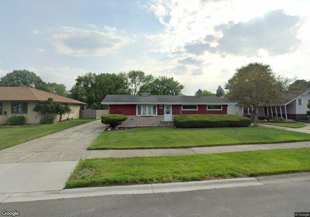
17538 Maple Ave Lansing, IL 60438
Estimated Value: $204,295 - $238,000
3
Beds
2
Baths
1,300
Sq Ft
$174/Sq Ft
Est. Value
About This Home
This home is located at 17538 Maple Ave, Lansing, IL 60438 and is currently estimated at $226,074, approximately $173 per square foot. 17538 Maple Ave is a home located in Cook County with nearby schools including Coolidge Elementary School, Memorial Jr High School, and Thornton Fractnl So High School.
Ownership History
Date
Name
Owned For
Owner Type
Purchase Details
Closed on
Jan 9, 2016
Sold by
Washington Tyrone
Bought by
Washington Tyrone and Williams Marquita
Current Estimated Value
Purchase Details
Closed on
Aug 22, 2014
Sold by
White Selma E
Bought by
Washington Tyrone
Home Financials for this Owner
Home Financials are based on the most recent Mortgage that was taken out on this home.
Original Mortgage
$113,247
Interest Rate
3.75%
Mortgage Type
FHA
Purchase Details
Closed on
Dec 2, 2008
Sold by
White Selma E
Bought by
White Selma E and White George L
Purchase Details
Closed on
Aug 17, 2000
Sold by
White George L and White Selma E
Bought by
White George L and White Selma E
Create a Home Valuation Report for This Property
The Home Valuation Report is an in-depth analysis detailing your home's value as well as a comparison with similar homes in the area
Home Values in the Area
Average Home Value in this Area
Purchase History
| Date | Buyer | Sale Price | Title Company |
|---|---|---|---|
| Washington Tyrone | -- | None Available | |
| Washington Tyrone | $120,000 | None Available | |
| White Selma E | -- | None Available | |
| White George L | -- | -- |
Source: Public Records
Mortgage History
| Date | Status | Borrower | Loan Amount |
|---|---|---|---|
| Previous Owner | Washington Tyrone | $113,247 |
Source: Public Records
Tax History
| Year | Tax Paid | Tax Assessment Tax Assessment Total Assessment is a certain percentage of the fair market value that is determined by local assessors to be the total taxable value of land and additions on the property. | Land | Improvement |
|---|---|---|---|---|
| 2025 | $5,169 | $14,000 | $4,858 | $9,142 |
| 2024 | $5,169 | $14,000 | $4,858 | $9,142 |
| 2023 | $4,777 | $14,000 | $4,858 | $9,142 |
| 2022 | $4,777 | $10,770 | $4,286 | $6,484 |
| 2021 | $4,703 | $10,770 | $4,286 | $6,484 |
| 2020 | $4,499 | $10,770 | $4,286 | $6,484 |
| 2019 | $4,890 | $12,019 | $4,000 | $8,019 |
| 2018 | $4,796 | $12,019 | $4,000 | $8,019 |
| 2017 | $4,877 | $12,019 | $4,000 | $8,019 |
| 2016 | $4,994 | $11,631 | $3,714 | $7,917 |
| 2015 | $5,909 | $11,631 | $3,714 | $7,917 |
| 2014 | $5,828 | $11,631 | $3,714 | $7,917 |
| 2013 | $1,720 | $13,336 | $3,714 | $9,622 |
Source: Public Records
Map
Nearby Homes
- 17509 Maple Ave
- 3645 177th Place
- 17702 Bernadine St
- 3520 Jackson St
- 17244 Wentworth Ave
- 17519 Community St
- 17614 Community St
- 108 Beverly Place
- 423 176th Ct
- 17913 William St
- 3617 Monroe St
- 17335 Community St
- 17945 Maple St
- 3636 172nd St
- 17552 Roy St
- 17518 Roy St
- 7937 Forest Ave
- 17204 Bernadine St
- 17831 Community St
- 3659 Madison St
- 17538 Maple St
- 17528 Maple Ave
- 17540 Maple Ave
- 17524 Maple Ave
- 17544 Maple Ave
- 17527 Shirley Dr
- 17521 Shirley Dr
- 17517 Shirley Dr
- 17539 Maple Dr
- 17525 Maple Ave
- 17520 Maple Ave
- 17533 Shirley Dr
- 17511 Shirley Dr
- 17600 Maple St
- 17516 Maple Ave
- 17527 Maple Dr
- 17516 Maple Ave
- 17523 Maple Ave
- 17537 Shirley Dr
Your Personal Tour Guide
Ask me questions while you tour the home.