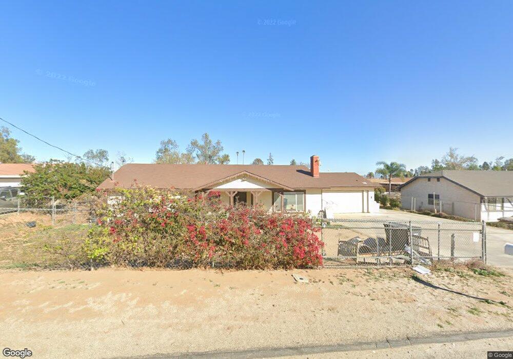
17550 Clark St Perris, CA 92570
Estimated Value: $533,000 - $620,000
3
Beds
2
Baths
1,730
Sq Ft
$325/Sq Ft
Est. Value
About This Home
This home is located at 17550 Clark St, Perris, CA 92570 and is currently estimated at $561,398, approximately $324 per square foot. 17550 Clark St is a home located in Riverside County with nearby schools including Mead Valley Elementary School, Tomas Rivera Middle School, and Citrus Hill High School.
Ownership History
Date
Name
Owned For
Owner Type
Purchase Details
Closed on
Apr 20, 2023
Sold by
Hernandez Roberto and Hernandez Lourdes
Bought by
Roberto And Lourdes Hernandez Living Trust
Current Estimated Value
Purchase Details
Closed on
Aug 25, 2009
Sold by
Deutsche Bank National Trust Company
Bought by
Hernandez Roberto and Hernandez Lourdes
Purchase Details
Closed on
Oct 23, 2007
Sold by
Mejia Raul Varela
Bought by
Deutsche Bank National Trust Co and Argent Mortgage Loan Trust Asset Backed
Purchase Details
Closed on
Jun 16, 2005
Sold by
Bangma Ronald J
Bought by
Mejia Raul Varela
Home Financials for this Owner
Home Financials are based on the most recent Mortgage that was taken out on this home.
Original Mortgage
$367,920
Interest Rate
5.3%
Mortgage Type
Purchase Money Mortgage
Purchase Details
Closed on
Jul 3, 2001
Sold by
Green Robert
Bought by
Green Douglas and Green Tracy
Home Financials for this Owner
Home Financials are based on the most recent Mortgage that was taken out on this home.
Original Mortgage
$151,261
Interest Rate
7.09%
Mortgage Type
FHA
Purchase Details
Closed on
May 20, 2001
Sold by
Green Douglas and Green Tracy
Bought by
Bangma Ronald J and Bangma Dana A
Home Financials for this Owner
Home Financials are based on the most recent Mortgage that was taken out on this home.
Original Mortgage
$151,261
Interest Rate
7.09%
Mortgage Type
FHA
Purchase Details
Closed on
May 24, 2000
Sold by
Green Robert
Bought by
Green Douglas and Green Tracy
Purchase Details
Closed on
May 4, 2000
Sold by
Green Robert
Bought by
Mutual Group Inc
Purchase Details
Closed on
Nov 2, 1999
Sold by
Pappagalo Ronald D and Pappagalo Jacqueline
Bought by
Green Robert
Home Financials for this Owner
Home Financials are based on the most recent Mortgage that was taken out on this home.
Original Mortgage
$151,100
Interest Rate
7.68%
Purchase Details
Closed on
Apr 7, 1998
Sold by
Benner Kenneth J and Benner Lori A
Bought by
Pappagalo Ronald D and Pappagalo Jacqueline
Home Financials for this Owner
Home Financials are based on the most recent Mortgage that was taken out on this home.
Original Mortgage
$138,173
Interest Rate
7.06%
Mortgage Type
FHA
Create a Home Valuation Report for This Property
The Home Valuation Report is an in-depth analysis detailing your home's value as well as a comparison with similar homes in the area
Home Values in the Area
Average Home Value in this Area
Purchase History
| Date | Buyer | Sale Price | Title Company |
|---|---|---|---|
| Roberto And Lourdes Hernandez Living Trust | -- | None Listed On Document | |
| Hernandez Roberto | $100,000 | Lsi Title Company Ca | |
| Deutsche Bank National Trust Co | $381,723 | Cr Title Services Inc | |
| Mejia Raul Varela | $462,000 | Lawyers Title Co | |
| Green Douglas | -- | -- | |
| Green Robert | -- | -- | |
| Bangma Ronald J | $155,000 | Old Republic Title Company | |
| Green Douglas | -- | -- | |
| Mutual Group Inc | -- | -- | |
| Green Robert | $138,000 | Landsafe Title | |
| Pappagalo Ronald D | $140,000 | Commonwealth Land Title Co |
Source: Public Records
Mortgage History
| Date | Status | Borrower | Loan Amount |
|---|---|---|---|
| Previous Owner | Mejia Raul Varela | $367,920 | |
| Previous Owner | Bangma Ronald J | $151,261 | |
| Previous Owner | Green Robert | $151,100 | |
| Previous Owner | Pappagalo Ronald D | $138,173 |
Source: Public Records
Tax History
| Year | Tax Paid | Tax Assessment Tax Assessment Total Assessment is a certain percentage of the fair market value that is determined by local assessors to be the total taxable value of land and additions on the property. | Land | Improvement |
|---|---|---|---|---|
| 2025 | $1,438 | $129,062 | $64,531 | $64,531 |
| 2023 | $1,438 | $124,052 | $62,026 | $62,026 |
| 2022 | $1,396 | $121,620 | $60,810 | $60,810 |
| 2021 | $1,369 | $119,236 | $59,618 | $59,618 |
| 2020 | $1,356 | $118,014 | $59,007 | $59,007 |
| 2019 | $1,274 | $115,700 | $57,850 | $57,850 |
| 2018 | $1,256 | $113,432 | $56,716 | $56,716 |
| 2017 | $1,227 | $111,208 | $55,604 | $55,604 |
| 2016 | $1,213 | $109,028 | $54,514 | $54,514 |
| 2015 | $1,195 | $107,394 | $53,697 | $53,697 |
| 2014 | $1,317 | $105,294 | $52,647 | $52,647 |
Source: Public Records
Map
Nearby Homes
- 0 Ryan St
- 20810 Oleander Ave
- 21701 Perry St
- 20646 Markham St
- 20398 Bailly St
- 22738 Redwood Dr
- 21131 Martin St
- 21285 Kinney St
- 19992 Covell St
- 20805 Golden Rain Rd
- 20715 Freeport Dr
- 18583 Seaton Ave
- 18251 Northstar Ave
- 20625 Stony Brook Cir
- 19795 Beavertail Way
- 0 Marquez Rd
- 17900 Nandina Ave
- 20785 Burns St
- 20516 Yate Cir
- 20329 Red Poppy Ln
- 17580 Clark St
- 17520 Clark St
- 21485 Nandina Ave
- 17600 Clark St
- 17612 Clark St
- 21470 Mayfield Ln
- 21421 Nandina Ave
- 21635 Nandina Ave
- 21450 Mayfield Ln
- 21377 Nandina Ave
- 21420 Mayfield Ln
- 17650 Clark St
- 17603 Clark St
- 21365 Nandina Ave
- 21635 Hawthorne Ave
- 21390 Mayfield Ln
- 17720 Clark St
- 21345 Mayfield Ln
- 17525 Carroll St
- 21626 Kuder Ave
Your Personal Tour Guide
Ask me questions while you tour the home.