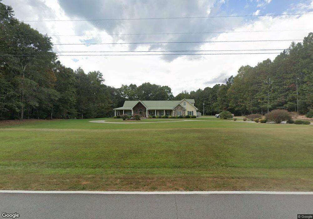
1759 Melear Rd Bowdon, GA 30108
Estimated Value: $516,000 - $737,787
5
Beds
8
Baths
3,972
Sq Ft
$158/Sq Ft
Est. Value
About This Home
This home is located at 1759 Melear Rd, Bowdon, GA 30108 and is currently estimated at $626,894, approximately $157 per square foot. 1759 Melear Rd is a home located in Carroll County with nearby schools including Mt. Zion Elementary School, Mt. Zion Middle School, and Mt. Zion High School.
Ownership History
Date
Name
Owned For
Owner Type
Purchase Details
Closed on
Sep 28, 2006
Sold by
Not Provided
Bought by
Beasley J Eugene and Beasley Karen G
Current Estimated Value
Purchase Details
Closed on
Aug 21, 2006
Sold by
Not Provided
Bought by
Beasley J Eugene and Beasley Karen G
Purchase Details
Closed on
Apr 7, 1998
Sold by
Runyon
Bought by
Runyon Valerie A
Create a Home Valuation Report for This Property
The Home Valuation Report is an in-depth analysis detailing your home's value as well as a comparison with similar homes in the area
Home Values in the Area
Average Home Value in this Area
Purchase History
| Date | Buyer | Sale Price | Title Company |
|---|---|---|---|
| Beasley J Eugene | -- | -- | |
| Beasley J Eugene | $175,080 | -- | |
| Runyon Valerie A | -- | -- |
Source: Public Records
Tax History
| Year | Tax Paid | Tax Assessment Tax Assessment Total Assessment is a certain percentage of the fair market value that is determined by local assessors to be the total taxable value of land and additions on the property. | Land | Improvement |
|---|---|---|---|---|
| 2025 | $1,637 | $313,091 | $14,952 | $298,139 |
| 2024 | $1,655 | $313,091 | $14,952 | $298,139 |
| 2023 | $1,669 | $368,343 | $17,592 | $350,751 |
| 2022 | $1,832 | $293,490 | $11,728 | $281,762 |
| 2021 | $1,743 | $252,596 | $9,382 | $243,214 |
| 2020 | $1,664 | $222,435 | $8,529 | $213,906 |
| 2019 | $1,626 | $209,212 | $8,529 | $200,683 |
| 2018 | $1,581 | $191,526 | $7,971 | $183,555 |
| 2017 | $1,593 | $191,526 | $7,971 | $183,555 |
| 2016 | $1,594 | $191,526 | $7,971 | $183,555 |
| 2015 | $1,537 | $143,219 | $7,475 | $135,744 |
| 2014 | $1,432 | $139,138 | $7,475 | $131,663 |
Source: Public Records
Map
Nearby Homes
- Melear Rd
- 0 Kansas Jake Rd Unit 26132658
- 0 Kansas Jake Rd Unit 10676294
- 0 Kansas Jake Rd Unit 26114165
- 0 Kansas Jake Rd Unit 26114173
- 0 Kansas Jake Rd Unit 26877980
- 0 N Highway 100 Unit TRACT 2 10571032
- 0 N Highway 100 Unit TRACT 3 10571036
- 0 N Highway 100 Unit TRACT 4 10571038
- 1960 N Highway 100
- 1000 Kansas Jake Rd
- 80 Hand Rd
- 183 Madden Rd
- 1495 Kansas Jake Rd
- 695 Frost Rd
- 353 S Prospect Ave
- 1405 Burwell Rd
- 140 Martin Cemetery Rd
- 128 Martin Cemetery Rd
- 120 Martin Cemetery Rd
- 1801 Melear Rd
- 1740 Melear Rd
- 1831 Melear Rd
- 1683 Melear Rd Unit TRACT 2
- 1683 Melear Rd
- 1680 Melear Rd
- 1645 Melear Rd
- 1609 Melear Rd
- 1569 Melear Rd
- 175 Styles Dr
- 1541 Melear Rd
- 500 Thomas Rd
- 467 Thomas Rd
- 1527 Melear Rd
- 2275 N Highway 100
- 2255 N Highway 100
- 1464 Melear Rd
- 255 Lucky Ln
- 223 Lucky Ln
- 215 Lucky Ln
Your Personal Tour Guide
Ask me questions while you tour the home.