Estimated Value: $827,460 - $1,732,000
3
Beds
1
Bath
1,206
Sq Ft
$964/Sq Ft
Est. Value
About This Home
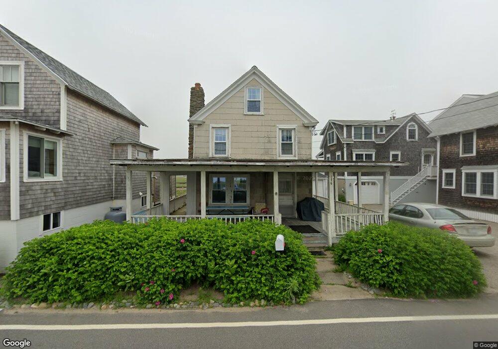
This home is located at 176 Atlantic Ave, Wells, ME 04090 and is currently estimated at $1,162,365, approximately $963 per square foot. 176 Atlantic Ave is a home located in York County with nearby schools including Wells Junior High School, Wells Elementary School, and Wells High School.
Ownership History
Date
Name
Owned For
Owner Type
Purchase Details
Closed on
Jul 16, 2020
Sold by
Jewell Kelleher K
Bought by
Kelleher Ft and Kelleher
Current Estimated Value
Purchase Details
Closed on
Jul 24, 2013
Sold by
Clapp June M Est and Cooke
Bought by
Franklin Susan and Cooke Carolyn
Create a Home Valuation Report for This Property
The Home Valuation Report is an in-depth analysis detailing your home's value as well as a comparison with similar homes in the area
Home Values in the Area
Average Home Value in this Area
Purchase History
| Date | Buyer | Sale Price | Title Company |
|---|---|---|---|
| Kelleher Ft | -- | None Available | |
| Kelleher Ft | -- | None Available | |
| Kelleher Ft | -- | None Available | |
| Franklin Susan | -- | -- | |
| Franklin Susan | -- | -- |
Source: Public Records
Tax History Compared to Growth
Tax History
| Year | Tax Paid | Tax Assessment Tax Assessment Total Assessment is a certain percentage of the fair market value that is determined by local assessors to be the total taxable value of land and additions on the property. | Land | Improvement |
|---|---|---|---|---|
| 2024 | $5,055 | $831,410 | $636,160 | $195,250 |
| 2023 | $4,955 | $831,410 | $636,160 | $195,250 |
| 2022 | $5,014 | $479,350 | $375,280 | $104,070 |
| 2021 | $4,970 | $472,480 | $370,440 | $102,040 |
| 2020 | $4,557 | $434,810 | $375,280 | $59,530 |
| 2019 | $4,507 | $432,530 | $375,280 | $57,250 |
| 2018 | $4,464 | $432,530 | $375,280 | $57,250 |
| 2017 | $4,395 | $432,530 | $375,280 | $57,250 |
| 2016 | $4,351 | $432,530 | $375,280 | $57,250 |
| 2015 | $4,304 | $432,530 | $375,280 | $57,250 |
| 2013 | $3,945 | $432,530 | $375,280 | $57,250 |
Source: Public Records
Map
Nearby Homes
- 229 Atlantic Ave
- 61 Atlantic Ave Unit 3
- 58 Atlantic Ave Unit 12B
- 46 Ox Cart Ln
- 9 Robert Ln
- 42 Rachel Carson Ln
- 446 Atlantic Ave
- 500 Atlantic Ave Unit 2
- 4 Tidal Ct
- 60 Merrifield Ct
- 2 Gold Ribbon Dr
- 1351 Post Rd Unit 49
- 1072 Post Rd Unit 131
- 1072 Post Rd Unit 111
- 99 Harbor Rd Unit Lot 52
- 99 Harbor Rd Unit Lot 54
- 105 Harbor Rd
- 1373 Post Rd Unit 10A
- 1373 Post Rd Unit 4E
- 1373 Post Rd Unit 2C
- 178 Atlantic Ave
- 182 Atlantic Ave
- 172 Atlantic Ave
- 179 Atlantic Ave
- 175 Atlantic Ave
- 186 Atlantic Ave
- 183 Atlantic Ave
- 190 Atlantic Ave
- 187 Atlantic Ave
- 171 Atlantic Ave
- 168 Atlantic Ave
- 189 Atlantic Ave
- 194 Atlantic Ave
- 166 Atlantic Ave
- 166 Atlantic Ave Unit ID1248591P
- 00 Route 2 Silver Ridge
- 0 Molunkus Lake Unit 903884
- 1530 Fifteen - Thirty Road T1 R5 We
- 1 Fraser Camp Rd
- 8 Fifth Ave