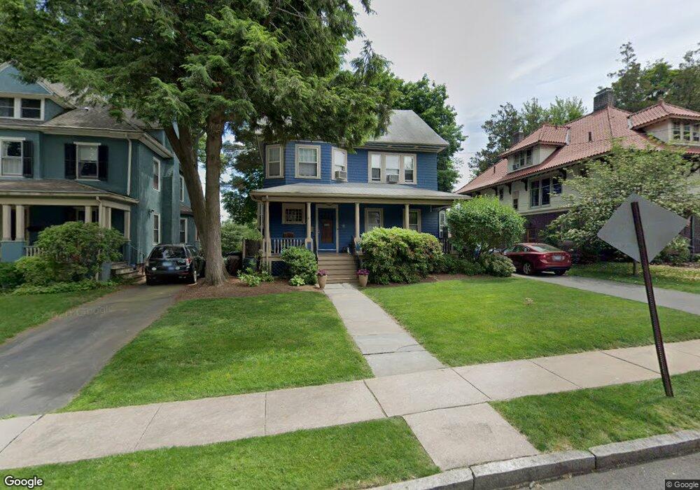
176 Kenyon St Hartford, CT 06105
West End NeighborhoodEstimated Value: $448,000 - $526,000
4
Beds
3
Baths
2,453
Sq Ft
$198/Sq Ft
Est. Value
About This Home
This home is located at 176 Kenyon St, Hartford, CT 06105 and is currently estimated at $484,943, approximately $197 per square foot. 176 Kenyon St is a home located in Hartford County with nearby schools including Noah Webster Micro Society School, West Middle School, and Breakthrough Magnet School - North Campus.
Ownership History
Date
Name
Owned For
Owner Type
Purchase Details
Closed on
Nov 15, 2021
Sold by
Shikora Phyllis F
Bought by
Phyllis F Shikora Ret and Shikora
Current Estimated Value
Purchase Details
Closed on
Aug 31, 1988
Sold by
Musumeci Joseph
Bought by
Cohen Douglas A
Create a Home Valuation Report for This Property
The Home Valuation Report is an in-depth analysis detailing your home's value as well as a comparison with similar homes in the area
Home Values in the Area
Average Home Value in this Area
Purchase History
| Date | Buyer | Sale Price | Title Company |
|---|---|---|---|
| Phyllis F Shikora Ret | -- | None Available | |
| Shikora Phyllis F | -- | None Available | |
| Cohen Douglas A | $255,000 | -- |
Source: Public Records
Mortgage History
| Date | Status | Borrower | Loan Amount |
|---|---|---|---|
| Previous Owner | Cohen Douglas A | $105,000 | |
| Previous Owner | Cohen Douglas A | $99,000 | |
| Previous Owner | Cohen Douglas A | $211,500 | |
| Previous Owner | Cohen Douglas A | $12,000 |
Source: Public Records
Tax History
| Year | Tax Paid | Tax Assessment Tax Assessment Total Assessment is a certain percentage of the fair market value that is determined by local assessors to be the total taxable value of land and additions on the property. | Land | Improvement |
|---|---|---|---|---|
| 2025 | $8,278 | $120,062 | $37,265 | $82,797 |
| 2024 | $8,278 | $120,062 | $37,265 | $82,797 |
| 2023 | $8,278 | $120,062 | $37,265 | $82,797 |
| 2022 | $8,278 | $120,063 | $37,265 | $82,798 |
| 2021 | $7,202 | $96,950 | $35,490 | $61,460 |
| 2020 | $7,202 | $96,950 | $35,490 | $61,460 |
| 2019 | $7,202 | $96,950 | $35,490 | $61,460 |
| 2018 | $6,960 | $93,681 | $34,293 | $59,388 |
| 2016 | $6,741 | $90,736 | $32,661 | $58,075 |
| 2015 | $6,741 | $86,426 | $31,110 | $55,316 |
| 2014 | $6,264 | $84,313 | $30,349 | $53,964 |
Source: Public Records
Map
Nearby Homes
- 120 Whitney St
- 28 Whitney St
- 799 Prospect Ave Unit 5
- 799 Prospect Ave Unit 6
- 779 Prospect Ave Unit 7
- 779 Prospect Ave Unit 14
- 31 Woodland St Unit 4I
- 31 Woodland St Unit 6N
- 31 Woodland St Unit 4G
- 31 Woodland St Unit 1J
- 30 Woodland St Unit 9H
- 30 Woodland St Unit 5H
- 40 Owen St Unit B5
- 621 Farmington Ave
- 187 S Whitney St Unit 189
- 544 Prospect Ave
- 175 Scarborough St
- 16-20 Townley St Unit K2
- 16-20 Townley St Unit G3
- 15 Townley St
- 154 Kenyon St
- 184 Kenyon St
- 186 Kenyon St
- 175 Kenyon St Unit 177
- 171 Kenyon St Unit 173
- 171 Girard Ave
- 150 Kenyon St
- 165 Girard Ave
- 194 Kenyon St
- 181 Girard Ave
- 163 Girard Ave
- 157 Kenyon St
- 185 Girard Ave
- 179 Kenyon St
- 198 Kenyon St
- 148 Kenyon St
- 155 Girard Ave
- 183 Kenyon St
- 149 Kenyon St
- 189 Kenyon St
Your Personal Tour Guide
Ask me questions while you tour the home.