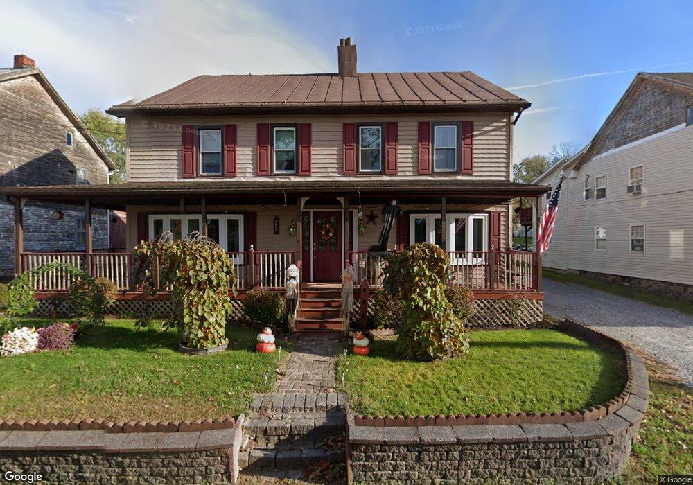
176 Wellsville Rd Wellsville, PA 17365
Warrington Township NeighborhoodEstimated Value: $253,245 - $286,000
4
Beds
2
Baths
1,512
Sq Ft
$178/Sq Ft
Est. Value
About This Home
This home is located at 176 Wellsville Rd, Wellsville, PA 17365 and is currently estimated at $269,061, approximately $177 per square foot. 176 Wellsville Rd is a home located in York County with nearby schools including Northern Middle School and Northern High School.
Ownership History
Date
Name
Owned For
Owner Type
Purchase Details
Closed on
Nov 4, 2024
Sold by
Weir James D and Weir Eva M
Bought by
James D Weir Sr & Eva Mae Weir Living Trust and Weir
Current Estimated Value
Purchase Details
Closed on
Sep 17, 1986
Bought by
Weir James D and Weir Eva M
Create a Home Valuation Report for This Property
The Home Valuation Report is an in-depth analysis detailing your home's value as well as a comparison with similar homes in the area
Home Values in the Area
Average Home Value in this Area
Purchase History
| Date | Buyer | Sale Price | Title Company |
|---|---|---|---|
| James D Weir Sr & Eva Mae Weir Living Trust | -- | None Listed On Document | |
| James D Weir Sr & Eva Mae Weir Living Trust | -- | None Listed On Document | |
| Weir James D | -- | -- |
Source: Public Records
Tax History Compared to Growth
Tax History
| Year | Tax Paid | Tax Assessment Tax Assessment Total Assessment is a certain percentage of the fair market value that is determined by local assessors to be the total taxable value of land and additions on the property. | Land | Improvement |
|---|---|---|---|---|
| 2025 | $3,712 | $136,240 | $37,680 | $98,560 |
| 2024 | $3,671 | $136,240 | $37,680 | $98,560 |
| 2023 | $3,598 | $136,240 | $37,680 | $98,560 |
| 2022 | $3,521 | $136,240 | $37,680 | $98,560 |
| 2021 | $3,291 | $136,240 | $37,680 | $98,560 |
| 2020 | $3,213 | $136,240 | $37,680 | $98,560 |
| 2019 | $3,132 | $136,240 | $37,680 | $98,560 |
| 2018 | $3,065 | $136,240 | $37,680 | $98,560 |
| 2017 | $3,065 | $136,240 | $37,680 | $98,560 |
| 2016 | $0 | $136,240 | $37,680 | $98,560 |
| 2015 | -- | $136,240 | $37,680 | $98,560 |
| 2014 | -- | $136,240 | $37,680 | $98,560 |
Source: Public Records
Map
Nearby Homes
- Tract #1 Carlisle Rd
- 270 S Winding Rd
- 0 W Camping Area Rd
- 138 S Peiffer Rd
- 375 Mount Zion Rd
- 265 Pine Woods Rd
- 6691 Harmony Grove Rd
- 160 Myers Rd
- 22 Bentz Mill Rd
- 6520 Old Carlisle Rd
- 580 S Kralltown Rd
- 10 Hull Dr
- 2530 Sky Top Trail
- 6200 Old Carlisle Rd
- 206 Bentz Mill Rd
- 107 Pickett Rd
- 480 Mount Airy Rd Unit 13
- 5790 Carlisle Rd
- 1967 Pinetown Rd
- 5840 Old Carlisle Rd
- 186 Wellsville Rd
- 172 Wellsville Rd
- 184 Wellsville Rd
- 160 Wellsville Rd
- 174 Wellsville Rd
- 182 Wellsville Rd
- 188 Wellsville Rd
- 129 York St
- 0 York St Unit 4 21202462
- 127 York St
- 54 Warrington St
- 120 Wellsville Rd
- 128 York St
- 79 Warrington St
- 125 York St
- 77 Warrington St
- 73 Warrington St
- 46 Warrington St
- 140 Wellsville Rd
- 71 Warrington St