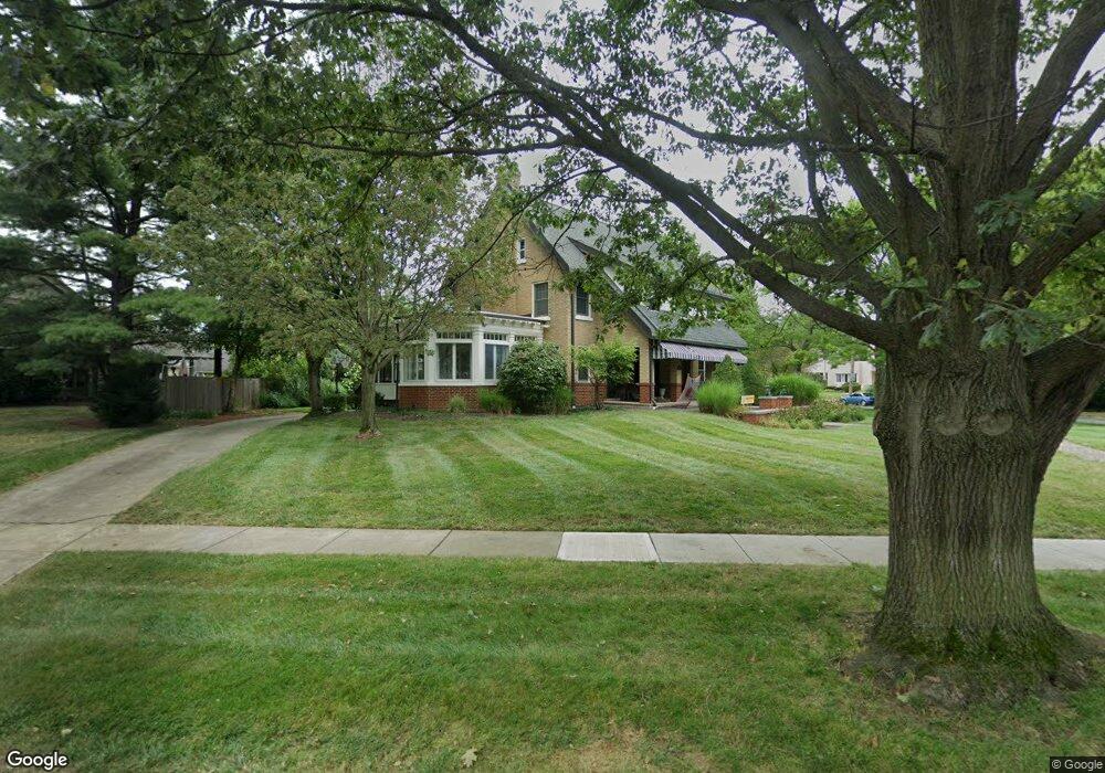
1760 Cambridge Blvd Columbus, OH 43212
Estimated Value: $1,269,000 - $1,894,000
4
Beds
3
Baths
4,738
Sq Ft
$311/Sq Ft
Est. Value
About This Home
This home is located at 1760 Cambridge Blvd, Columbus, OH 43212 and is currently estimated at $1,474,900, approximately $311 per square foot. 1760 Cambridge Blvd is a home located in Franklin County with nearby schools including Barrington Road Elementary School, Jones Middle School, and Upper Arlington High School.
Ownership History
Date
Name
Owned For
Owner Type
Purchase Details
Closed on
Oct 8, 2020
Sold by
Christie Robert Morgan and Burt Lindsay Taylor
Bought by
Goode Breet
Current Estimated Value
Home Financials for this Owner
Home Financials are based on the most recent Mortgage that was taken out on this home.
Original Mortgage
$692,000
Interest Rate
2.75%
Mortgage Type
New Conventional
Purchase Details
Closed on
Jun 29, 1981
Bought by
Christie John S and Christie Linda M
Purchase Details
Closed on
May 1, 1978
Create a Home Valuation Report for This Property
The Home Valuation Report is an in-depth analysis detailing your home's value as well as a comparison with similar homes in the area
Home Values in the Area
Average Home Value in this Area
Purchase History
| Date | Buyer | Sale Price | Title Company |
|---|---|---|---|
| Goode Breet | $865,000 | World Class Title | |
| Christie John S | -- | -- | |
| -- | $74,900 | -- |
Source: Public Records
Mortgage History
| Date | Status | Borrower | Loan Amount |
|---|---|---|---|
| Previous Owner | Goode Breet | $692,000 |
Source: Public Records
Tax History Compared to Growth
Tax History
| Year | Tax Paid | Tax Assessment Tax Assessment Total Assessment is a certain percentage of the fair market value that is determined by local assessors to be the total taxable value of land and additions on the property. | Land | Improvement |
|---|---|---|---|---|
| 2024 | $35,061 | $403,100 | $154,140 | $248,960 |
| 2023 | $23,409 | $403,095 | $154,140 | $248,955 |
| 2022 | $21,156 | $302,760 | $111,830 | $190,930 |
| 2021 | $18,743 | $302,760 | $111,830 | $190,930 |
| 2020 | $19,873 | $324,140 | $111,830 | $212,310 |
| 2019 | $20,024 | $288,760 | $111,830 | $176,930 |
| 2018 | $9,955 | $288,760 | $111,830 | $176,930 |
| 2017 | $21,567 | $313,430 | $139,790 | $173,640 |
| 2016 | $14,536 | $218,340 | $86,770 | $131,570 |
| 2015 | $7,262 | $218,340 | $86,770 | $131,570 |
| 2014 | $14,440 | $218,340 | $86,770 | $131,570 |
| 2013 | $6,945 | $198,485 | $78,890 | $119,595 |
Source: Public Records
Map
Nearby Homes
- 1934 Bedford Rd
- 2015 W 5th Ave Unit 211
- 2015 W 5th Ave Unit 102
- 2015 W 5th Ave Unit 108
- 1631 Roxbury Rd Unit D2
- 1631 Roxbury Rd Unit A1
- 1631 Roxbury Rd Unit B6
- 1659 Tremont Rd
- 1733 Elmwood Ave
- 1561 Glenn Ave
- 1729 Elmwood Ave
- 1655-1657 Ashland Ave
- 1661 Ashland Ave Unit 663
- 2110 Northwest Blvd
- 1825 Northwest Ct Unit D
- 1932 Suffolk Rd Unit 1932
- 2357 Keep Place Unit 2357
- 1313 Lincoln Rd
- 1398 Lower Green Cir Unit 1398
- 2276 Northwest Blvd
- 1777 Coventry Rd
- 1790 Cambridge Blvd
- 1785 Coventry Rd
- 1910 King Ave
- 1800 N Devon Rd
- 1767 Cambridge Blvd
- 1766 Coventry Rd
- 1791 Coventry Rd
- 1771 Cambridge Blvd
- 1755 Cambridge Blvd
- 1810 N Devon Rd
- 1745 Cambridge Blvd
- 1772 Coventry Rd
- 1894 King Ave
- 1799 Coventry Rd
- 1737 Cambridge Blvd
- 1788 Coventry Rd
- 1816 N Devon Rd
- 1768 Arlington Ave
- 1800 Cambridge Blvd