Estimated Value: $192,000 - $208,109
3
Beds
1
Bath
1,416
Sq Ft
$141/Sq Ft
Est. Value
About This Home
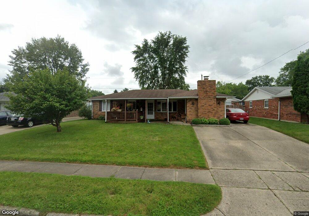
This home is located at 1761 Pueblo Dr, Xenia, OH 45385 and is currently estimated at $199,527, approximately $140 per square foot. 1761 Pueblo Dr is a home located in Greene County with nearby schools including Xenia High School, Summit Academy Community School for Alternative Learners - Xenia, and Legacy Christian Academy.
Ownership History
Date
Name
Owned For
Owner Type
Purchase Details
Closed on
Jan 11, 2022
Sold by
Perkins Jonathan R
Bought by
Walton Julia A
Current Estimated Value
Purchase Details
Closed on
Apr 20, 2001
Sold by
Hile William R and Gutch Roberta L
Bought by
Perkins Jonathan Ross
Home Financials for this Owner
Home Financials are based on the most recent Mortgage that was taken out on this home.
Original Mortgage
$42,500
Interest Rate
7.02%
Purchase Details
Closed on
Oct 26, 1998
Sold by
Walton Julia A
Bought by
Perkins Jonathan R and Walton Julia A
Purchase Details
Closed on
Nov 2, 1994
Sold by
Pottle Glenn W
Bought by
Walton Julia L
Home Financials for this Owner
Home Financials are based on the most recent Mortgage that was taken out on this home.
Original Mortgage
$73,875
Interest Rate
8.75%
Mortgage Type
FHA
Create a Home Valuation Report for This Property
The Home Valuation Report is an in-depth analysis detailing your home's value as well as a comparison with similar homes in the area
Home Values in the Area
Average Home Value in this Area
Purchase History
| Date | Buyer | Sale Price | Title Company |
|---|---|---|---|
| Walton Julia A | -- | None Listed On Document | |
| Perkins Jonathan Ross | $50,000 | -- | |
| Perkins Jonathan R | -- | -- | |
| Walton Julia L | $74,500 | -- |
Source: Public Records
Mortgage History
| Date | Status | Borrower | Loan Amount |
|---|---|---|---|
| Previous Owner | Perkins Jonathan Ross | $42,500 | |
| Previous Owner | Walton Julia L | $73,875 |
Source: Public Records
Tax History Compared to Growth
Tax History
| Year | Tax Paid | Tax Assessment Tax Assessment Total Assessment is a certain percentage of the fair market value that is determined by local assessors to be the total taxable value of land and additions on the property. | Land | Improvement |
|---|---|---|---|---|
| 2024 | $2,288 | $53,460 | $11,140 | $42,320 |
| 2023 | $2,288 | $53,460 | $11,140 | $42,320 |
| 2022 | $1,878 | $38,400 | $6,550 | $31,850 |
| 2021 | $1,903 | $38,400 | $6,550 | $31,850 |
| 2020 | $1,822 | $38,400 | $6,550 | $31,850 |
| 2019 | $1,621 | $32,160 | $6,370 | $25,790 |
| 2018 | $1,627 | $32,160 | $6,370 | $25,790 |
| 2017 | $1,488 | $32,160 | $6,370 | $25,790 |
| 2016 | $1,488 | $28,880 | $6,370 | $22,510 |
| 2015 | $1,492 | $28,880 | $6,370 | $22,510 |
| 2014 | $1,428 | $28,880 | $6,370 | $22,510 |
Source: Public Records
Map
Nearby Homes
- 1778 Arapaho Dr
- 1618 Navajo Dr
- 1403 Texas Dr
- 1272 Bellbrook Ave
- 1653 Seneca Dr
- 1769 Gayhart Dr
- 1208 Bellbrook Ave
- 1866 Roxbury Dr
- 1829 Gayhart Dr
- 1908 Whitt St
- 1144 Rockwell Dr
- 1568 Cheyenne Dr
- 1255 Colorado Dr
- 1107 Arkansas Dr
- 2758 Wyoming Dr
- 2142 Michigan Dr
- 161 Montana Dr
- 2257 Maryland Dr
- 1342 Kylemore Dr
- 414 Whisper Ln