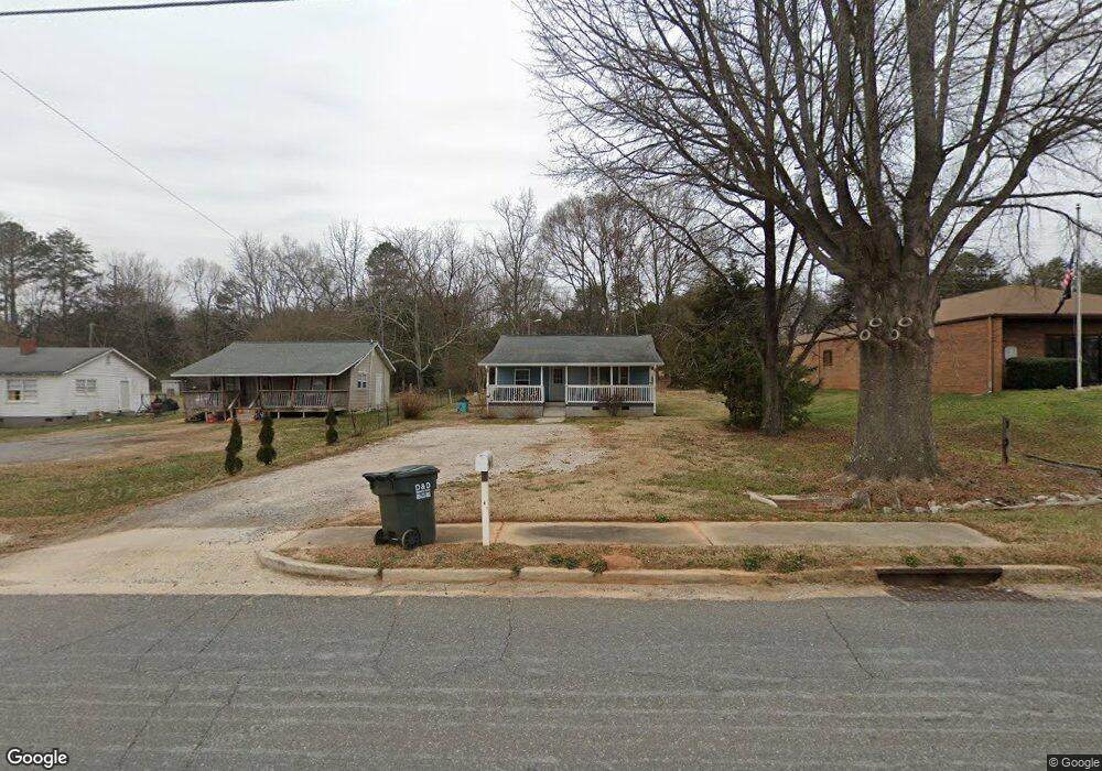
1763 Highway 321 N Clover, SC 29710
Estimated Value: $109,318 - $145,000
--
Bed
--
Bath
690
Sq Ft
$184/Sq Ft
Est. Value
About This Home
This home is located at 1763 Highway 321 N, Clover, SC 29710 and is currently estimated at $126,830, approximately $183 per square foot. 1763 Highway 321 N is a home with nearby schools including Kinard Elementary School, Clover Middle School, and Clover High School.
Ownership History
Date
Name
Owned For
Owner Type
Purchase Details
Closed on
Aug 15, 2023
Sold by
Adams Chad Alfred
Bought by
Lopez Angie Alapizar
Current Estimated Value
Home Financials for this Owner
Home Financials are based on the most recent Mortgage that was taken out on this home.
Original Mortgage
$85,000
Outstanding Balance
$70,565
Interest Rate
6.81%
Mortgage Type
Seller Take Back
Estimated Equity
$56,265
Purchase Details
Closed on
Aug 29, 2022
Sold by
Eubanks Jr Willie B
Bought by
Adams Chad Alfred
Purchase Details
Closed on
Jun 24, 2013
Sold by
Eubanks Willie B
Bought by
Eubanks Willie B and Eubanks Charlotte
Purchase Details
Closed on
Mar 11, 2013
Sold by
Estate Of Willie B Eubanks
Bought by
Eubanks Willie B and Eubanks Terry Wayne
Purchase Details
Closed on
Jun 16, 1999
Sold by
Liverett Jacqueline J
Bought by
Westmoreland James D
Create a Home Valuation Report for This Property
The Home Valuation Report is an in-depth analysis detailing your home's value as well as a comparison with similar homes in the area
Home Values in the Area
Average Home Value in this Area
Purchase History
| Date | Buyer | Sale Price | Title Company |
|---|---|---|---|
| Lopez Angie Alapizar | $85,000 | None Listed On Document | |
| Adams Chad Alfred | $55,000 | None Listed On Document | |
| Eubanks Willie B | -- | -- | |
| Eubanks Willie B | $40,000 | -- | |
| Eubanks Willie B | -- | -- | |
| Westmoreland James D | $30,000 | -- |
Source: Public Records
Mortgage History
| Date | Status | Borrower | Loan Amount |
|---|---|---|---|
| Open | Lopez Angie Alapizar | $85,000 |
Source: Public Records
Tax History Compared to Growth
Tax History
| Year | Tax Paid | Tax Assessment Tax Assessment Total Assessment is a certain percentage of the fair market value that is determined by local assessors to be the total taxable value of land and additions on the property. | Land | Improvement |
|---|---|---|---|---|
| 2025 | $1,999 | $4,986 | $2,280 | $2,706 |
| 2024 | $1,904 | $4,894 | $2,040 | $2,854 |
| 2023 | $1,962 | $5,196 | $2,040 | $3,156 |
| 2022 | $223 | $2,070 | $1,063 | $1,007 |
| 2021 | -- | $2,070 | $1,063 | $1,007 |
| 2020 | $219 | $2,070 | $0 | $0 |
| 2019 | $209 | $1,800 | $0 | $0 |
| 2018 | $211 | $1,800 | $0 | $0 |
| 2017 | $195 | $1,800 | $0 | $0 |
| 2016 | $192 | $1,800 | $0 | $0 |
| 2014 | $190 | $1,800 | $800 | $1,000 |
| 2013 | $190 | $1,800 | $800 | $1,000 |
Source: Public Records
Map
Nearby Homes
- 880 Bellegray Rd Unit 19
- 844 Bellegray Rd Unit 16
- 832 Bellegray Rd
- 808 Bellegray Rd Unit 13
- 3841 Shasta Cir
- Zina TH Plan at Penley Place Townhomes
- Longfield TH Plan at Penley Place Townhomes
- 7019 Sonja Dr
- 3901 Shasta Cir
- 393 Drawbar Dr Unit 126
- 405 Drawbar Dr Unit 131
- 5909 Crawford Rd
- 424 Drawbar Dr Unit 51
- 420 Drawbar Dr Unit 53
- 3948 Shasta Cir
- 924 Ferguson Ridge Rd
- 518 Canopy Ct
- 746 Ladino Ln
- 1310 State Road S-46-1197
- 910 Torsion Ln
- 1755 Highway 321 N
- 1747 Highway 321 N
- 1739 Highway 321 N
- 1731 Highway 321 N
- 1719 Highway 321 N
- 1705 Highway 321 N
- 1687 Highway 321 N
- 1684 Highway 321 N
- 100 Cedar Oak Dr
- 1680 Highway 321 N
- 1676 Highway 321 N
- 142 Cedar Oak Dr
- 142 Cedar Oak Rd
- 1820 U S 321
- 1667 Highway 321 N
- 1645 Dulin Rd
- 1799 Highway 321 N
- 1662 Highway 321 N
- 1821 U S 321
- 1821 Highway 321 N