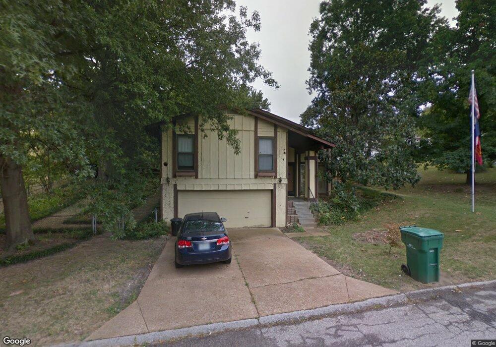
1766 Burgess Way Barnhart, MO 63012
Estimated Value: $203,758 - $226,000
--
Bed
--
Bath
1,260
Sq Ft
$175/Sq Ft
Est. Value
About This Home
This home is located at 1766 Burgess Way, Barnhart, MO 63012 and is currently estimated at $219,940, approximately $174 per square foot. 1766 Burgess Way is a home with nearby schools including Windsor High School and St. Joseph Catholic School.
Ownership History
Date
Name
Owned For
Owner Type
Purchase Details
Closed on
Dec 21, 2022
Sold by
Teitsort Kyle
Bought by
Smith Richard Eric
Current Estimated Value
Purchase Details
Closed on
Aug 12, 2015
Sold by
Fog Raymond J and Fog Barbara A
Bought by
Smith Laura M and Smith Eric
Purchase Details
Closed on
Nov 5, 2010
Sold by
Rodgers Jimmie W and Rodgers Christine L
Bought by
Moser Victor M and Moser Susan R
Purchase Details
Closed on
Jul 13, 1998
Sold by
Fog Raymond J and Fog Barbara A
Bought by
Fog Raymond J and Fog Barbara A
Create a Home Valuation Report for This Property
The Home Valuation Report is an in-depth analysis detailing your home's value as well as a comparison with similar homes in the area
Home Values in the Area
Average Home Value in this Area
Purchase History
| Date | Buyer | Sale Price | Title Company |
|---|---|---|---|
| Smith Richard Eric | -- | None Listed On Document | |
| Smith Richard Eric | -- | -- | |
| Smith Laura M | -- | None Available | |
| Moser Victor M | -- | Continental Title Company | |
| Fog Raymond J | -- | -- |
Source: Public Records
Tax History Compared to Growth
Tax History
| Year | Tax Paid | Tax Assessment Tax Assessment Total Assessment is a certain percentage of the fair market value that is determined by local assessors to be the total taxable value of land and additions on the property. | Land | Improvement |
|---|---|---|---|---|
| 2025 | $1,737 | $27,000 | $5,000 | $22,000 |
| 2024 | $1,737 | $23,700 | $4,000 | $19,700 |
| 2023 | $1,737 | $23,700 | $4,000 | $19,700 |
| 2022 | $1,580 | $21,600 | $1,900 | $19,700 |
| 2021 | $1,581 | $21,600 | $1,900 | $19,700 |
| 2020 | $1,463 | $19,400 | $1,600 | $17,800 |
| 2019 | $1,461 | $19,400 | $1,600 | $17,800 |
| 2018 | $1,442 | $19,400 | $1,600 | $17,800 |
| 2017 | $1,387 | $19,400 | $1,600 | $17,800 |
| 2016 | $1,263 | $17,600 | $1,700 | $15,900 |
| 2015 | $1,259 | $17,600 | $1,700 | $15,900 |
| 2013 | -- | $17,200 | $1,700 | $15,500 |
Source: Public Records
Map
Nearby Homes
- 1728 Fairfax Dr
- 7255 Meriwether Ct
- 7062 Tuckahoe Ct
- 7056 Albermarle Ct
- 7013 Wayles Dr
- 7009 Albermarle Ct
- 7098 Ridge Dr
- 1022 Graystone Park
- 7075 Metropolitan Blvd
- 2090 Birchwood Dr
- 2030 Engle Ridge Rd
- 0 Hwy Mm Unit MAR24032005
- 6788 Haven Hill Rd
- 6625 Dry Creek Rd
- 1675 Old State Road M
- 0 New Highway M Unit MAR25024234
- 0 Highland Terrace
- 6 Huntleigh Woods
- 6555 Pauline Ct
- 2000 Lot 10 Crossroads Rd
- 1764 Burgess Way
- 7250 Wayles Dr
- 7382 Wayles Dr
- 7247 Wayles Dr
- 1761 Burgess Way
- 1745 Dandridge Ln
- 7246 Wayles Dr
- 1741 Dandridge Ln
- 1735 Dandridge Ln
- 1753 Dandridge Ln
- 7245 Wayles Dr
- 7242 Wayles Dr
- 1731 Dandridge Ln
- 1759 Burgess Way
- 1757 Dandridge Ln
- 1748 Dandridge Ln
- 7243 Wayles Dr
- 1760 Burgess Way
- 1744 Dandridge Ln
- 1725 Dandridge Ln