$100,000
SOLD JAN 24, 2025

1766 Whale Rock Rd Bellvue, CO 80512

40 Acres
$2,500 Price per Acre
1,742,400 Sq Ft Lot

Recently Sold

184 Days on Market

Highlights

  • Horses Allowed On Property
  • Hiking Trails
  • Lot Has A Rolling Slope
  • 40 Acre Lot

About This Lot

As of January 2025

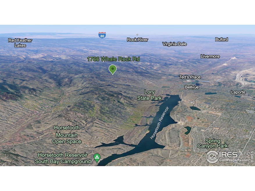
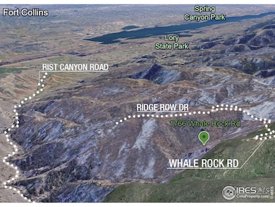
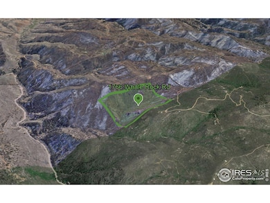
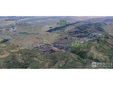
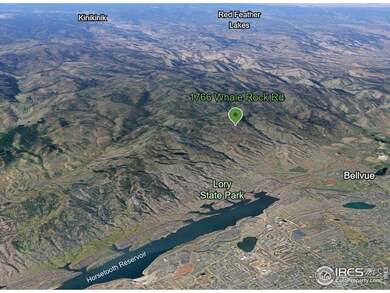
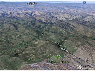
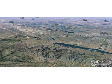
Your chance to secure your own 40 Acres in the hills just outside of the Fort Collins/Bellvue area. 15 minutes to Bellvue, and 20 minutes to Horsetooth Reservoir or North-West Fort Collins. Great investment opportunity substantially below existing market price for land/acreage in Northern Colorado. This property is affected and located in the burn scar from the High Park fire of 2012. Buy now and let the value increase as the land recovers. Zoning is appropriate for up to 16 horses, or other animals in accordance with Larimer County Land Use codes. Whale Rock Road and the Rist Canyon area bring fantastic privacy, abundant natural beauty, and rich local history. Start your journey of owning land in this area today!

Last Agent to Sell the Property

Chris Johnston

LC Real Estate Group, LLC

Co-Listed By

Samantha Beck

Summit Real Estate & Marketing

Last Buyer's Agent

Suzannah Mattson

LPT Realty, LLC.

LPT Realty, LLC.

Property Details

Property Type

  • Land

Year Built

  • 1979

Lot Details

  • 40 Acre Lot
  • Dirt Road
  • Rock Outcropping
  • Lot Has A Rolling Slope
  • Property is zoned Open (O)

HOA Fees

  • $17 Monthly HOA Fees

Schools

  • Cache La Poudre Elementary And Middle School
  • Poudre High School

Horse Facilities and Amenities

  • Horses Allowed On Property
  • Riding Trail

Listing and Financial Details

  • Assessor Parcel Number R0000345

Community Details

Overview

  • 330870 S33 T08 R70 Subdivision

Recreation

  • Hiking Trails

Property Details

Property Type

Land

Year Built

1979

Lot Details

0

HOA Fees

$17 per month

Listing Details

  • Development Status: Raw Land
  • Property Sub Type: Unimproved Land
  • Prop. Type: Land
  • Horses: Yes
  • Lot Size Acres: 40
  • Road Frontage Type: Priv Rd up to County Standards
  • Road Surface Type: Dirt
  • Co List Office Mls Id: SREM
  • Subdivision Name: 330870 - S33 T08 R70
  • Directions: From Fort Collins, exit town and head North on US-287 N toward CO-1N. Keep left and at the traffic circle, take the 2nd exit to continue onto U.S. 287 B. In 2.7 miles continue slight left onto W County Rd 52 E / Rist Canyon Rd. Continue to follow Rist Canyon Road for approximately 4.2 miles, then turn left onto Whale Rock Road. Continue up Whale Rock Road for 1.8 miles until Ridge Row Dr. Property is located between Ridge Row Dr. and Whale Rock Road with property entrance off of Whale Rock Road on the South side of the parcel.
  • Special Features: None
  • Year Built (Public Record): 1979

Interior Features

  • Possible Use: Single Family, Farm

Exterior Features

  • Lot Features: Rolling Slope, Rock Outcropping
  • View: Foothills View
  • Waterfront: No

Utilities

  • Sewer: No Water/Sewer
  • Water Source: No Water/Sewer, N/A

Condo/Co-op/Association

  • Community Features: Hiking/Biking Trails
  • Senior Community: No
  • Association Fee: 200
  • Association Fee Frequency: Annually
  • Association: Yes

Association/Amenities

  • IRESDS_HasAssociationReserve: No
  • IRESDS_HasAssociationFee: Yes

Schools

  • Elementary School: Cache La Poudre
  • HighSchool: Poudre
  • Junior High Dist: Poudre
  • Middle Or Junior School: Cache La Poudre

Lot Info

  • Zoning: Open (O)
  • Current Use: Zoning Appropriate for 4+ Horses
  • Horse Amenities: Riding Trail
  • Lot Size Sq Ft: 1742400
  • Parcel #: R0000345
  • ResoLotSizeUnits: SquareFeet

Tax Info

  • Tax Year: 2023
  • Tax Annual Amount: 2130

Multi Family

Map

Range of Values:

Collateral Analytics

Collateral Analytics Collateral Analytics AVMs (Automated Valuation Model) employ a number of statistical approaches combined with neighborhood-specific comparable selection guarantees the most up-to-date and precise valuations.

Not Available

Collateral Analytics does not have data for the current month. Please view the chart for historical values.

ICE

ICE Mortgage Technology ICE Mortgage Technology’s AVM (Automated Valuation Model) is a state-of-the-art online residential property valuation tool that provides a quick and accurate estimate of the value of almost any home in the U.S.

Not Available

ICE Mortgage Technology does not have data for the current month. Please view the chart for historical values.

First American

First American First American Data & Analytics’ next-generation AVM combines unrivaled data assets with a blended ensemble of valuation models to produce highly accurate, reliable valuations you can trust.

Not Available

First American does not have data for the current month. Please view the chart for historical values.

Quantarium

Quantarium Quantarium’s valuation service, repeatedly proven the industry’s most accurate and comprehensive, is supercharged with a self-learning and auto-tuning AI engine that continually becomes smarter and more accurate as it processes daily inputs from the industry’s leading RE data lake.

Not Available

Quantarium does not have data for the current month. Please view the chart for historical values.

Average Value
Not Available
List Price
Sold Price
Create a Home Valuation Report for This Property
The Home Valuation Report is an in-depth analysis detailing your home's value as well as a comparison with similar homes in the area

Home Values in the Area

Source: Public Records

Average Home Value in this Area


Source: Public Records

Property History

Date Event Price Change Sq Ft Price
01/24/2025 01/24/25 Sold $100,000 0.0% --
01/07/2025 01/07/25 For Sale $100,000 0.0% --
01/06/2025 01/06/25 Off Market $100,000 -- --
07/24/2024 07/24/24 For Sale $100,000 -- --
Source: IRES MLS

Tax History

Year Tax Paid Tax Assessment Tax Assessment Total Assessment is a certain percentage of the fair market value that is determined by local assessors to be the total taxable value of land and additions on the property. Land Improvement
2025 $2,130 $26,505 $26,505 --
2024 $2,130 $26,505 $26,505 --
2022 $1,711 $20,909 $20,909 --
2021 $1,711 $20,909 $20,909 $0
2020 $2,037 $24,650 $24,650 $0
2019 $2,047 $24,650 $24,650 $0
2018 $1,733 $21,605 $21,605 $0
2017 $1,726 $21,605 $21,605 $0
2016 $256 $3,184 $3,184 $0
2015 $254 $3,180 $3,180 $0
2014 $166 $2,070 $2,070 $0
Source: Public Records

Deed History

Date Type Sale Price Title Company
Warranty Deed $100,000 First American Title
Quit Claim Deed -- None Available
Quit Claim Deed -- --
Interfamily Deed Transfer -- --
Quit Claim Deed -- --
Interfamily Deed Transfer -- --
Interfamily Deed Transfer $9,000 --
Interfamily Deed Transfer -- --
Source: Public Records

Source: IRES MLS

MLS Number: 1014967

IRES MLS

APN: 08330-00-030