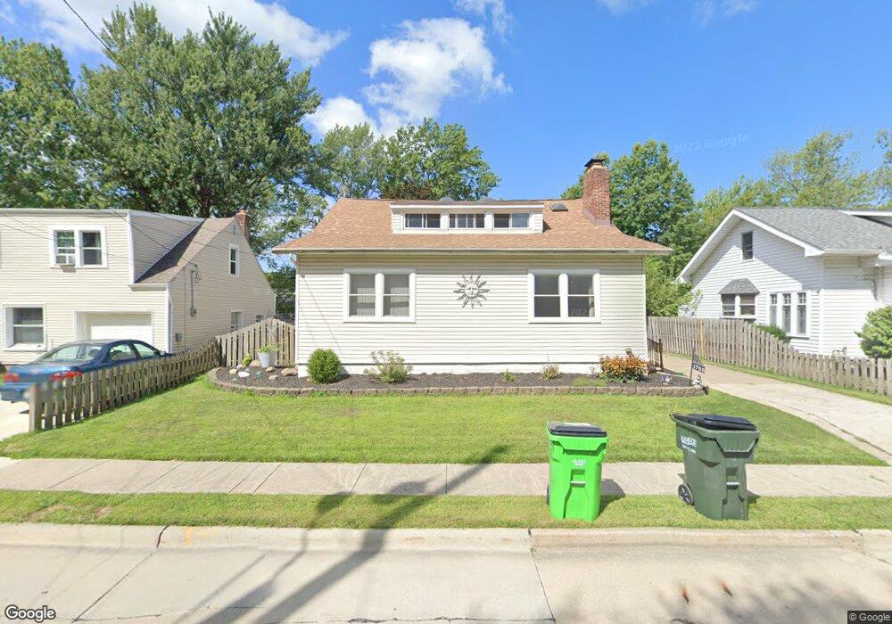
1768 Harding Dr Wickliffe, OH 44092
Estimated Value: $185,000 - $222,000
2
Beds
2
Baths
1,190
Sq Ft
$171/Sq Ft
Est. Value
About This Home
This home is located at 1768 Harding Dr, Wickliffe, OH 44092 and is currently estimated at $203,461, approximately $170 per square foot. 1768 Harding Dr is a home located in Lake County with nearby schools including Wickliffe Elementary School, Wickliffe Middle School, and Wickliffe High School.
Ownership History
Date
Name
Owned For
Owner Type
Purchase Details
Closed on
Dec 2, 1997
Sold by
Fayne Sandra L
Bought by
Fayne Michael R and Fayne Sandra L
Current Estimated Value
Purchase Details
Closed on
Jul 25, 1994
Sold by
Dillon Sean W
Bought by
Fayne Michael R and Fayne Sandra L
Home Financials for this Owner
Home Financials are based on the most recent Mortgage that was taken out on this home.
Original Mortgage
$94,760
Interest Rate
9%
Mortgage Type
VA
Create a Home Valuation Report for This Property
The Home Valuation Report is an in-depth analysis detailing your home's value as well as a comparison with similar homes in the area
Home Values in the Area
Average Home Value in this Area
Purchase History
| Date | Buyer | Sale Price | Title Company |
|---|---|---|---|
| Fayne Michael R | -- | Midland Title Security Inc | |
| Fayne Michael R | $92,000 | -- |
Source: Public Records
Mortgage History
| Date | Status | Borrower | Loan Amount |
|---|---|---|---|
| Closed | Fayne Michael R | $94,760 |
Source: Public Records
Tax History
| Year | Tax Paid | Tax Assessment Tax Assessment Total Assessment is a certain percentage of the fair market value that is determined by local assessors to be the total taxable value of land and additions on the property. | Land | Improvement |
|---|---|---|---|---|
| 2025 | -- | $54,270 | $14,570 | $39,700 |
| 2024 | -- | $54,270 | $14,570 | $39,700 |
| 2023 | $5,446 | $44,280 | $12,600 | $31,680 |
| 2022 | $3,241 | $44,280 | $12,600 | $31,680 |
| 2021 | $3,254 | $44,280 | $12,600 | $31,680 |
| 2020 | $3,063 | $35,420 | $10,080 | $25,340 |
| 2019 | $3,062 | $35,420 | $10,080 | $25,340 |
| 2018 | $2,672 | $37,290 | $13,000 | $24,290 |
| 2017 | $2,689 | $37,290 | $13,000 | $24,290 |
| 2016 | $2,676 | $37,290 | $13,000 | $24,290 |
| 2015 | $2,630 | $37,290 | $13,000 | $24,290 |
| 2014 | $2,324 | $37,290 | $13,000 | $24,290 |
| 2013 | $2,323 | $37,290 | $13,000 | $24,290 |
Source: Public Records
Map
Nearby Homes
- 1648 Douglas Rd
- 1522 Mapledale Rd
- 1677 Mapledale Rd
- 34345 Giovanni Ave
- 1554 Rush Rd
- 5430 Oak Ridge Dr
- 30530 Grant St
- 30335 Euclid Ave Unit 40 and 20
- 5084 Shepherds Glen
- 5082 Shepherds Glen
- 5095 Shepherds Glen
- 5091 Shepherds Glen
- 5093 Shepherds Glen
- 5089 Shepherds Glen
- 5076 Shepherds Glen
- 5085 Shepherds Glen
- 5083 Shepherds Glen
- 5081 Shepherds Glen
- 5079 Shepherds Glen
- 261 Chelsea Dr
- 1764 Harding Dr
- 1770 Harding Dr
- 1800 Harding Dr
- 1748 Harding Dr
- 1769 Harding Dr
- 1771 Harding Dr
- 1763 Harding Dr
- 1801 Harding Dr
- 1757 Harding Dr
- 1806 Harding Dr
- 1740 Harding Dr
- 1571 Empire Rd
- 1577 Empire Rd
- 1581 Empire Rd
- 1807 Harding Dr
- 1598 Mapledale Rd
- 1749 Harding Dr
- 1588 Mapledale Rd
- 1585 Empire Rd
- 1602 Mapledale Rd
Your Personal Tour Guide
Ask me questions while you tour the home.