Estimated Value: $252,000 - $271,000
3
Beds
2
Baths
1,416
Sq Ft
$184/Sq Ft
Est. Value
About This Home
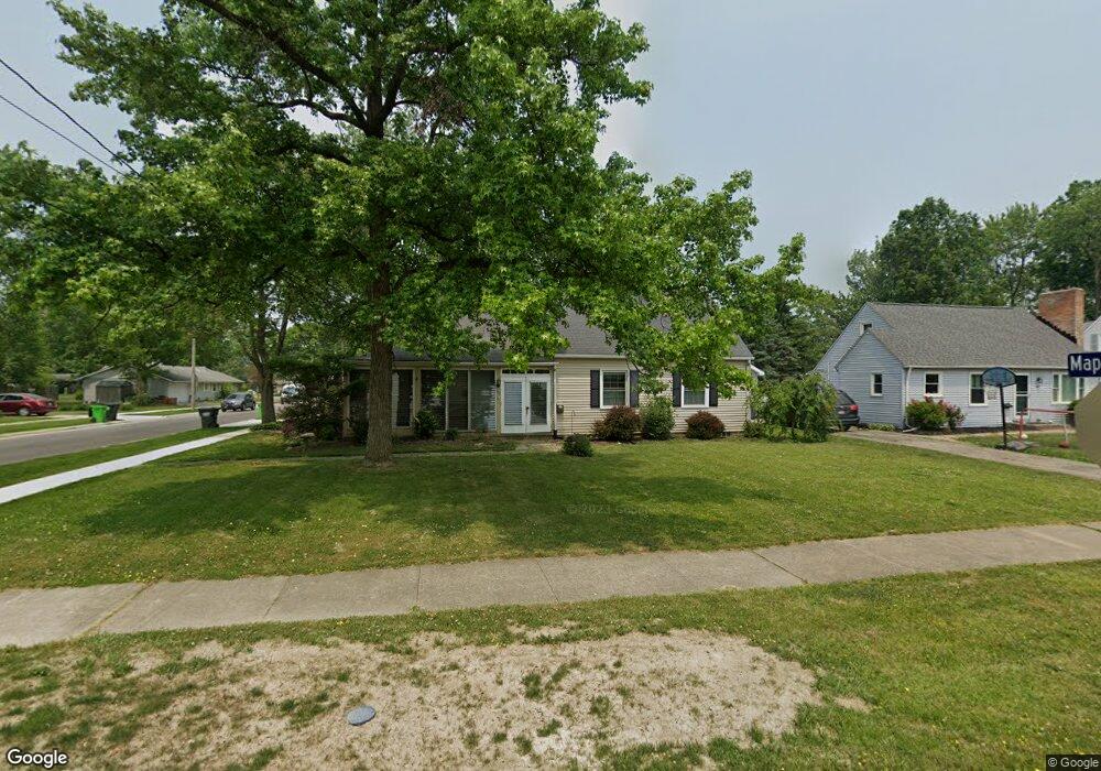
This home is located at 177 E 5th Ave, Berea, OH 44017 and is currently estimated at $260,639, approximately $184 per square foot. 177 E 5th Ave is a home located in Cuyahoga County with nearby schools including Grindstone Elementary School, Berea-Midpark Middle School, and Berea-Midpark High School.
Ownership History
Date
Name
Owned For
Owner Type
Purchase Details
Closed on
Mar 26, 2014
Sold by
Mikulka Elizabeth A and Sandhoff Elizabeth A
Bought by
Mikulka John F
Current Estimated Value
Home Financials for this Owner
Home Financials are based on the most recent Mortgage that was taken out on this home.
Original Mortgage
$123,117
Outstanding Balance
$95,016
Interest Rate
4.75%
Mortgage Type
FHA
Estimated Equity
$165,623
Purchase Details
Closed on
Jul 11, 2001
Sold by
Herwerden Richard E
Bought by
Mikulka John F and Sandhoff Elizabeth A
Home Financials for this Owner
Home Financials are based on the most recent Mortgage that was taken out on this home.
Original Mortgage
$133,850
Interest Rate
7.27%
Purchase Details
Closed on
Jul 26, 1993
Sold by
Uveges Ii Alfred C
Bought by
Herwerden Richard E
Purchase Details
Closed on
Sep 27, 1990
Sold by
Seidler Minnie F
Bought by
Uveges Ii Alfred C
Purchase Details
Closed on
Jan 1, 1975
Bought by
Seidler Minnie F
Create a Home Valuation Report for This Property
The Home Valuation Report is an in-depth analysis detailing your home's value as well as a comparison with similar homes in the area
Home Values in the Area
Average Home Value in this Area
Purchase History
| Date | Buyer | Sale Price | Title Company |
|---|---|---|---|
| Mikulka John F | -- | Southern Title | |
| Mikulka John F | $138,000 | -- | |
| Herwerden Richard E | $113,000 | -- | |
| Uveges Ii Alfred C | $95,500 | -- | |
| Seidler Minnie F | -- | -- |
Source: Public Records
Mortgage History
| Date | Status | Borrower | Loan Amount |
|---|---|---|---|
| Open | Mikulka John F | $123,117 | |
| Closed | Mikulka John F | $133,850 |
Source: Public Records
Tax History
| Year | Tax Paid | Tax Assessment Tax Assessment Total Assessment is a certain percentage of the fair market value that is determined by local assessors to be the total taxable value of land and additions on the property. | Land | Improvement |
|---|---|---|---|---|
| 2024 | $4,394 | $76,020 | $16,870 | $59,150 |
| 2023 | $3,771 | $54,610 | $12,150 | $42,460 |
| 2022 | $3,748 | $54,600 | $12,150 | $42,460 |
| 2021 | $3,716 | $54,600 | $12,150 | $42,460 |
| 2020 | $5,185 | $46,270 | $10,290 | $35,980 |
| 2019 | $3,455 | $132,200 | $29,400 | $102,800 |
| 2018 | $3,442 | $46,270 | $10,290 | $35,980 |
| 2017 | $3,719 | $46,480 | $8,820 | $37,660 |
| 2016 | $3,691 | $46,480 | $8,820 | $37,660 |
| 2015 | $3,467 | $46,480 | $8,820 | $37,660 |
| 2014 | $3,633 | $48,410 | $9,210 | $39,200 |
Source: Public Records
Map
Nearby Homes
- 56 3rd Ave
- 0 E Bagley Rd Unit 5111166
- 20415 Brookstone Trail
- 41 W 5th Ave
- 93 W 5th Ave
- 445 Berea St
- 57 Riverside Dr
- 452 N Rocky River Dr
- 725 Shakespeare Dr
- 487 Karen Dr
- 47 Prospect St
- 211 W Bridge St
- 209 Gibson St
- 49 Monroe St
- 146 Marian Ln
- 6574 Burton Dr
- 160 Marian Ln Unit 6A
- 275 Quarrystone Ln
- 216 Kraft St
- 7400 Engle Rd
Your Personal Tour Guide
Ask me questions while you tour the home.