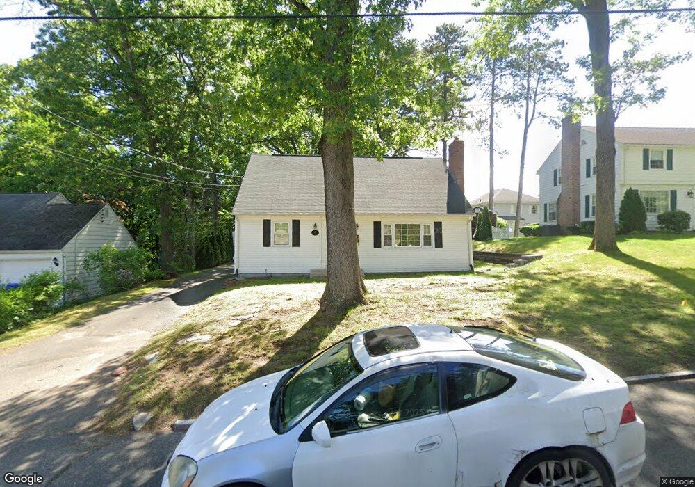
177 Emerson St Springfield, MA 01118
East Forest Park NeighborhoodEstimated Value: $333,549 - $359,000
4
Beds
2
Baths
1,638
Sq Ft
$213/Sq Ft
Est. Value
About This Home
This home is located at 177 Emerson St, Springfield, MA 01118 and is currently estimated at $349,387, approximately $213 per square foot. 177 Emerson St is a home located in Hampden County with nearby schools including Frederick Harris Elementary School, M Marcus Kiley Middle, and Springfield High School of Science and Technology.
Ownership History
Date
Name
Owned For
Owner Type
Purchase Details
Closed on
Sep 28, 2007
Sold by
Catanzarite Angela M and Catanzarite Joel
Bought by
Jackson Craig S
Current Estimated Value
Home Financials for this Owner
Home Financials are based on the most recent Mortgage that was taken out on this home.
Original Mortgage
$194,000
Outstanding Balance
$123,889
Interest Rate
6.65%
Mortgage Type
VA
Estimated Equity
$225,498
Purchase Details
Closed on
Feb 16, 1999
Sold by
Lasorsa Domenick M and Lasorsa Colleen E
Bought by
Catanzarite Joel and Catanzarite Angela M
Home Financials for this Owner
Home Financials are based on the most recent Mortgage that was taken out on this home.
Original Mortgage
$114,826
Interest Rate
6.78%
Mortgage Type
Purchase Money Mortgage
Create a Home Valuation Report for This Property
The Home Valuation Report is an in-depth analysis detailing your home's value as well as a comparison with similar homes in the area
Home Values in the Area
Average Home Value in this Area
Purchase History
| Date | Buyer | Sale Price | Title Company |
|---|---|---|---|
| Jackson Craig S | $194,000 | -- | |
| Catanzarite Joel | $114,900 | -- |
Source: Public Records
Mortgage History
| Date | Status | Borrower | Loan Amount |
|---|---|---|---|
| Open | Jackson Craig S | $194,000 | |
| Previous Owner | Catanzarite Joel | $114,826 | |
| Previous Owner | Catanzarite Joel | $90,000 | |
| Previous Owner | Catanzarite Joel | $96,000 |
Source: Public Records
Tax History
| Year | Tax Paid | Tax Assessment Tax Assessment Total Assessment is a certain percentage of the fair market value that is determined by local assessors to be the total taxable value of land and additions on the property. | Land | Improvement |
|---|---|---|---|---|
| 2025 | $4,152 | $264,800 | $38,400 | $226,400 |
| 2024 | $4,185 | $260,600 | $38,400 | $222,200 |
| 2023 | $3,906 | $229,100 | $39,900 | $189,200 |
| 2022 | $3,692 | $196,200 | $39,900 | $156,300 |
| 2021 | $3,387 | $179,200 | $36,300 | $142,900 |
| 2020 | $3,510 | $179,700 | $36,300 | $143,400 |
| 2019 | $3,438 | $174,700 | $36,300 | $138,400 |
| 2018 | $3,413 | $173,400 | $36,300 | $137,100 |
| 2017 | $3,179 | $161,700 | $36,300 | $125,400 |
| 2016 | $3,091 | $157,200 | $36,300 | $120,900 |
| 2015 | $2,998 | $152,400 | $36,300 | $116,100 |
Source: Public Records
Map
Nearby Homes
- 509 Plumtree Rd
- 101 Regal St
- 37 Chesterfield Ave
- 647 Plumtree Rd
- 75 Gillette Cir
- 384 Abbott St
- 7 Ashbrook St
- 19 Manor Ct Unit 19
- 55 Allen St
- 47 Hartford Terrace
- 79 Arvilla St
- 125 Manor Ct Unit 125
- 79 Roosevelt Ave
- 49 Corcoran Blvd
- 120 Bridle Path Rd
- 54 S Shore Dr
- 134 Eddywood St
- 1088 Sumner Ave
- 119 Powell Ave
- 170 Plumtree Rd
Your Personal Tour Guide
Ask me questions while you tour the home.