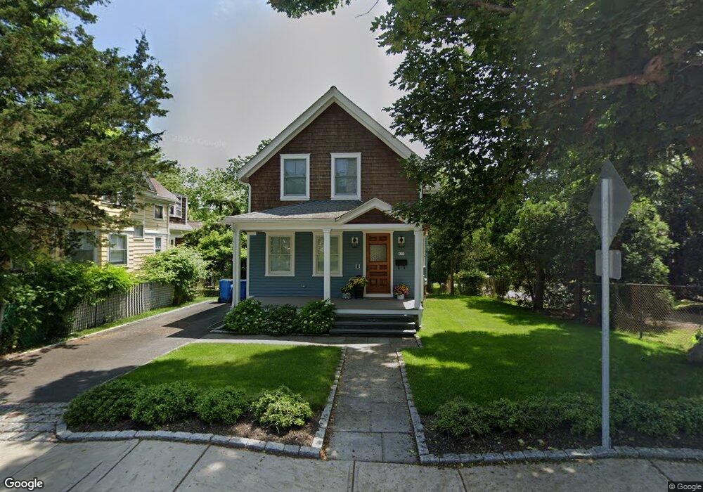
177 High St Wakefield, RI 02879
Estimated Value: $474,979 - $556,000
4
Beds
1
Bath
1,469
Sq Ft
$354/Sq Ft
Est. Value
About This Home
This home is located at 177 High St, Wakefield, RI 02879 and is currently estimated at $519,495, approximately $353 per square foot. 177 High St is a home located in Washington County with nearby schools including South Kingstown High School, Monsignor Matthew Clarke Catholic Regional School, and Bradley School-South.
Ownership History
Date
Name
Owned For
Owner Type
Purchase Details
Closed on
Feb 10, 2023
Sold by
Mcgannon Scott R and Mcgannon Christine M
Bought by
Mcgannon Christine M
Current Estimated Value
Purchase Details
Closed on
Oct 27, 2020
Sold by
Mcgannon Scott R
Bought by
Mcgannon Scott R and Mcgannon Christine M
Purchase Details
Closed on
Feb 27, 1975
Bought by
Mcgannon Raymonde A
Create a Home Valuation Report for This Property
The Home Valuation Report is an in-depth analysis detailing your home's value as well as a comparison with similar homes in the area
Home Values in the Area
Average Home Value in this Area
Purchase History
| Date | Buyer | Sale Price | Title Company |
|---|---|---|---|
| Mcgannon Christine M | -- | None Available | |
| Mcgannon Scott R | -- | None Available | |
| Mcgannon Scott R | -- | None Available | |
| Mcgannon Raymonde A | -- | -- |
Source: Public Records
Tax History
| Year | Tax Paid | Tax Assessment Tax Assessment Total Assessment is a certain percentage of the fair market value that is determined by local assessors to be the total taxable value of land and additions on the property. | Land | Improvement |
|---|---|---|---|---|
| 2025 | $3,389 | $379,100 | $145,100 | $234,000 |
| 2024 | $3,315 | $300,000 | $111,600 | $188,400 |
| 2023 | $3,315 | $300,000 | $111,600 | $188,400 |
| 2022 | $3,285 | $300,000 | $111,600 | $188,400 |
| 2021 | $3,193 | $221,000 | $92,000 | $129,000 |
| 2020 | $3,193 | $221,000 | $92,000 | $129,000 |
| 2019 | $3,193 | $221,000 | $92,000 | $129,000 |
| 2018 | $2,626 | $167,500 | $61,300 | $106,200 |
| 2017 | $2,564 | $167,500 | $61,300 | $106,200 |
| 2016 | $2,528 | $167,500 | $61,300 | $106,200 |
| 2015 | $2,583 | $166,400 | $65,000 | $101,400 |
| 2014 | $2,576 | $166,400 | $65,000 | $101,400 |
Source: Public Records
Map
Nearby Homes
- 48 Stone Bridge Dr
- 23 Rockland Dr
- 39 Hazard Ave
- 128 Rodman St
- 35 Whittier Dr
- 37 Whittier Dr
- 45 Cherry Ln Unit C
- 3 Larkin St
- 66 Christopher St
- 39 Secluded Dr
- 22 Beech Tree Place
- 260 Sweet Allen Farm Rd Unit 3
- 53 Rocky Brook Way
- 100 Spartina Cove Way
- 44 Vespia Ln
- 56 Vespia Ln
- 534 Curtis Corner Rd
- 918 Saugatucket Rd
- 1808 Kingstown Rd
- 507 Curtis Corner Rd
- 183 High St
- 169 High St
- 189 High St
- 161 High St
- 193 High St
- 0 Confidential St Unit 71361167
- 0 Confidential St Unit 71361166
- 0 Confidential St Unit 647890
- 0 Michaela Ct
- 0 - L-A73 Chickadee Ln Unit 73 1139833
- 0 - Lota61 Chickadee Ln Unit 1 1137140
- 23 8th St St E
- 0 Confidential St Unit 1102926
- 0 Michaela Ct Unit 1156653
- 18 Northup St
- 201 High St
- 12 Northup St
- 196 High St
- 198 High St
- 188 High St
Your Personal Tour Guide
Ask me questions while you tour the home.