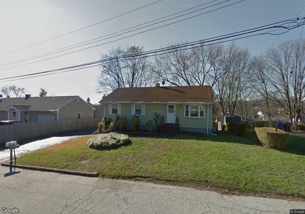
177 Little Deer Rd Bridgeport, CT 06606
North End NeighborhoodEstimated Value: $393,000 - $454,000
3
Beds
2
Baths
1,100
Sq Ft
$381/Sq Ft
Est. Value
About This Home
This home is located at 177 Little Deer Rd, Bridgeport, CT 06606 and is currently estimated at $418,628, approximately $380 per square foot. 177 Little Deer Rd is a home located in Fairfield County with nearby schools including John Winthrop School, Central High School, and St Andrew School.
Ownership History
Date
Name
Owned For
Owner Type
Purchase Details
Closed on
Sep 26, 2005
Sold by
Lambert John and Lambert Alice
Bought by
Taylor Stephanie
Current Estimated Value
Home Financials for this Owner
Home Financials are based on the most recent Mortgage that was taken out on this home.
Original Mortgage
$214,400
Outstanding Balance
$131,034
Interest Rate
8.1%
Estimated Equity
$287,594
Create a Home Valuation Report for This Property
The Home Valuation Report is an in-depth analysis detailing your home's value as well as a comparison with similar homes in the area
Home Values in the Area
Average Home Value in this Area
Purchase History
| Date | Buyer | Sale Price | Title Company |
|---|---|---|---|
| Taylor Stephanie | $268,000 | -- | |
| Taylor Stephanie | $268,000 | -- |
Source: Public Records
Mortgage History
| Date | Status | Borrower | Loan Amount |
|---|---|---|---|
| Open | Taylor Stephanie | $214,400 | |
| Closed | Taylor Stephanie | $214,400 |
Source: Public Records
Tax History Compared to Growth
Tax History
| Year | Tax Paid | Tax Assessment Tax Assessment Total Assessment is a certain percentage of the fair market value that is determined by local assessors to be the total taxable value of land and additions on the property. | Land | Improvement |
|---|---|---|---|---|
| 2025 | $6,531 | $150,310 | $77,800 | $72,510 |
| 2024 | $6,531 | $150,310 | $77,800 | $72,510 |
| 2023 | $6,531 | $150,310 | $77,800 | $72,510 |
| 2022 | $6,531 | $150,310 | $77,800 | $72,510 |
| 2021 | $6,531 | $150,310 | $77,800 | $72,510 |
| 2020 | $6,642 | $123,030 | $60,960 | $62,070 |
| 2019 | $6,642 | $123,030 | $60,960 | $62,070 |
| 2018 | $6,689 | $123,030 | $60,960 | $62,070 |
| 2017 | $6,689 | $123,030 | $60,960 | $62,070 |
| 2016 | $6,689 | $123,030 | $60,960 | $62,070 |
| 2015 | $5,803 | $137,500 | $60,020 | $77,480 |
| 2014 | $5,803 | $137,500 | $60,020 | $77,480 |
Source: Public Records
Map
Nearby Homes
- 50 Greenhouse Rd Unit 65D
- 50 Greenhouse Rd Unit 42C
- 173 Anton Dr
- 394 Anton Dr
- 236 Edgemoor Rd Unit D
- 9 Patricia Rd Unit C
- 64 Dobson St
- 65 Dobson St
- 87 Oliver St
- 72 Herald Ave
- 265 Vincellette St
- 114 Oxford St
- 2998 Madison Ave Unit C
- 344 Cambridge St
- 84 Oxford St
- 230 Cherry Hill Dr Unit 2B
- 15 Cherry Hill Dr Unit 2A
- 288 Sunrise Terrace
- 2851 Old Town Rd
- 2800 Madison Ave Unit 1B
- 161 Little Deer Rd
- 193 Little Deer Rd
- 100 Sunburst Rd
- 166 Little Deer Rd
- 116 Sunburst Rd
- 86 Sunburst Rd
- 180 Little Deer Rd
- 149 Little Deer Rd
- 200 Little Deer Rd
- 209 Little Deer Rd
- 140 Little Deer Rd
- 70 Sunburst Rd
- 130 Sunburst Rd
- 150 Sunburst Rd
- 30 Corn Tassel Rd
- 56 Little Deer Rd
- 115 Sunburst Rd
- 70 Little Deer Rd
- 139 Little Deer Rd
- 220 Little Deer Rd