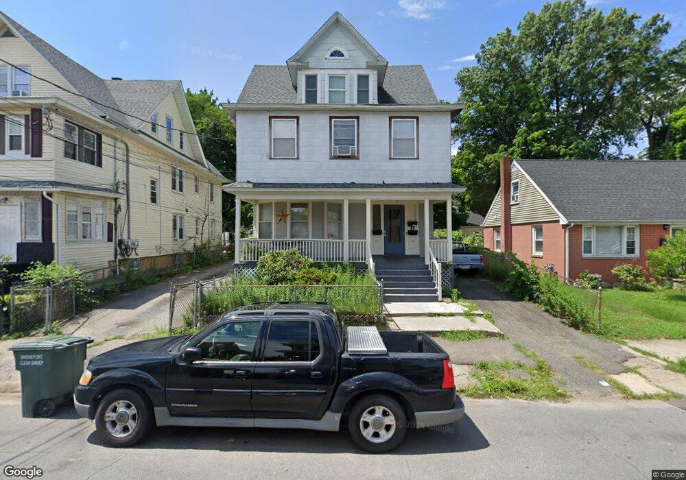
177 Pacific St Unit 179 Bridgeport, CT 06604
Brooklawn-Saint Vincent NeighborhoodEstimated Value: $399,459 - $683,000
6
Beds
3
Baths
3,399
Sq Ft
$163/Sq Ft
Est. Value
About This Home
This home is located at 177 Pacific St Unit 179, Bridgeport, CT 06604 and is currently estimated at $553,115, approximately $162 per square foot. 177 Pacific St Unit 179 is a home located in Fairfield County with nearby schools including Geraldine Johnson School, Bassick High School, and Merkaz Community High School for Judaic Studies.
Ownership History
Date
Name
Owned For
Owner Type
Purchase Details
Closed on
Feb 12, 1999
Sold by
Gill Robert M
Bought by
Thomas Jonathan A and Thomas Sylvia C
Current Estimated Value
Home Financials for this Owner
Home Financials are based on the most recent Mortgage that was taken out on this home.
Original Mortgage
$132,800
Outstanding Balance
$31,541
Interest Rate
6.78%
Estimated Equity
$521,574
Create a Home Valuation Report for This Property
The Home Valuation Report is an in-depth analysis detailing your home's value as well as a comparison with similar homes in the area
Home Values in the Area
Average Home Value in this Area
Purchase History
| Date | Buyer | Sale Price | Title Company |
|---|---|---|---|
| Thomas Jonathan A | $135,000 | -- | |
| Thomas Jonathan A | $135,000 | -- |
Source: Public Records
Mortgage History
| Date | Status | Borrower | Loan Amount |
|---|---|---|---|
| Open | Thomas Jonathan A | $132,800 | |
| Closed | Thomas Jonathan A | $132,800 |
Source: Public Records
Tax History Compared to Growth
Tax History
| Year | Tax Paid | Tax Assessment Tax Assessment Total Assessment is a certain percentage of the fair market value that is determined by local assessors to be the total taxable value of land and additions on the property. | Land | Improvement |
|---|---|---|---|---|
| 2025 | $9,494 | $218,500 | $78,440 | $140,060 |
| 2024 | $9,494 | $218,500 | $78,440 | $140,060 |
| 2023 | $9,494 | $218,500 | $78,440 | $140,060 |
| 2022 | $9,494 | $218,500 | $78,440 | $140,060 |
| 2021 | $9,494 | $218,500 | $78,440 | $140,060 |
| 2020 | $8,839 | $163,710 | $47,530 | $116,180 |
| 2019 | $8,839 | $163,710 | $47,530 | $116,180 |
| 2018 | $8,901 | $163,710 | $47,530 | $116,180 |
| 2017 | $8,901 | $163,710 | $47,530 | $116,180 |
| 2016 | $8,901 | $163,710 | $47,530 | $116,180 |
| 2015 | $8,640 | $204,740 | $50,320 | $154,420 |
| 2014 | $8,640 | $204,740 | $50,320 | $154,420 |
Source: Public Records
Map
Nearby Homes
- 184 Pacific St
- 687 Wood Ave
- 566 Wood Ave
- 700 Laurel Ave
- 2370 North Ave Unit 4C
- 2370 North Ave Unit 12G
- 2370 North Ave Unit 3F
- 697 Laurel Ave
- 860 Briarwood Ave
- 414 Wood Ave
- 366 Brooklawn Ave
- 74 Carleton Ave
- 670 Clinton Ave
- 665 W Taft Ave
- 826 Norman St
- 80 Cartright St Unit 8J
- 80 Cartright St Unit 2F
- 80 Cartright St Unit GC
- 80 Cartright St Unit 8B
- 100 Lorraine St
- 178 Pacific St Unit 180
- 166 Pacific St Unit 168
- 184 Pacific St Unit 2ndFl
- 184 Pacific St Unit 1
- 190 Pacific St Unit 2nd floor
- 190 Pacific St
- 188 Pacific St
- 188 Pacific St Unit 1st floor
- 160 Pacific St
- 160 Pacific St Unit 2
- 163 Pacific St Unit 165
- 191 Pacific St
- 173 Pacific St Unit 175
- 198 Pacific St
- 150 Pacific St
- 195 Pacific St
- 723 Wood Ave
- 731 Wood Ave
- 219 Pacific St Unit 221
- 715 Wood Ave