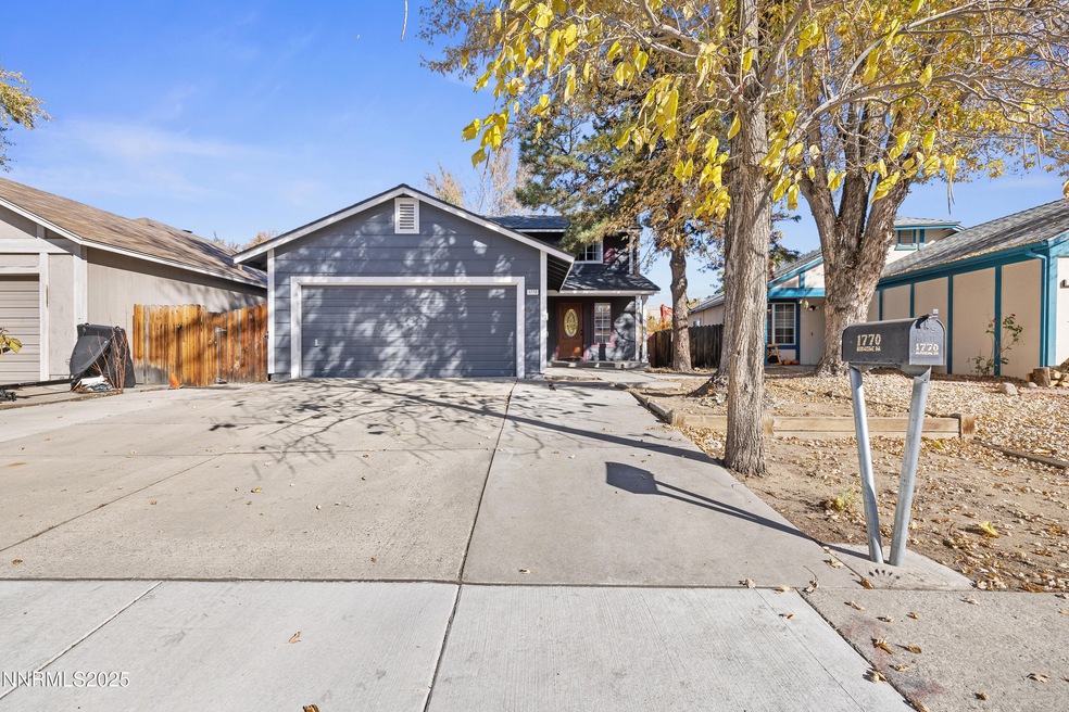

1770 Burnside Dr Sparks, NV 89434
O'Callaghan NeighborhoodEstimated payment $2,387/month
Highlights
- High Ceiling
- Covered Patio or Porch
- Double Pane Windows
- No HOA
- 2 Car Attached Garage
- Laundry Room
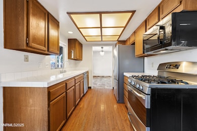
About This Home
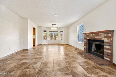
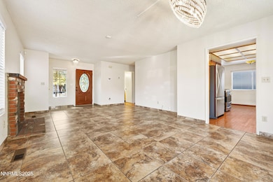
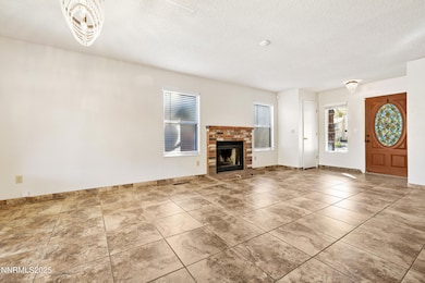
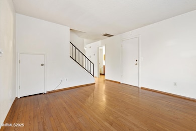
Location, location, location! This charming Sparks home offers the perfect blend of comfort, convenience, and value — situated just minutes from shopping, schools, the Sparks Marina, and easy freeway access. Step inside to find a light and inviting living space with an open floor plan ideal for everyday living or entertaining. The kitchen features ample cabinetry and counter space, flowing seamlessly into the dining and living areas. Enjoy three spacious bedrooms and two full baths, including a comfortable primary suite with generous closet space. Outside, the low-maintenance yard is perfect for relaxing or enjoying Northern Nevada's sunshine. Additional highlights include a two-car garage, central heating and cooling, and a quiet neighborhood setting close to parks and local amenities. Whether you're a first-time buyer, downsizing, or looking for an investment opportunity, this home offers great potential in one of Sparks' most convenient locations!
Home Details
Home Type
- Single Family
Est. Annual Taxes
- $1,902
Year Built
- Built in 1985
Lot Details
- 4,688 Sq Ft Lot
- Dog Run
- Back Yard Fenced
- Level Lot
- Property is zoned SF-6/PUD
Parking
- 2 Car Attached Garage
Home Design
- Shingle Roof
- Wood Siding
- Stick Built Home
Interior Spaces
- 1,508 Sq Ft Home
- 2-Story Property
- High Ceiling
- Ceiling Fan
- Wood Burning Fireplace
- Double Pane Windows
- Crawl Space
- Fire and Smoke Detector
Kitchen
- Gas Oven
- Gas Range
- Microwave
- Dishwasher
- Disposal
Flooring
- Carpet
- Laminate
- Ceramic Tile
- Vinyl
Bedrooms and Bathrooms
- 3 Bedrooms
- Primary Bathroom includes a Walk-In Shower
Laundry
- Laundry Room
- Laundry in Hall
Outdoor Features
- Covered Patio or Porch
Schools
- Dunn Elementary School
- Dilworth Middle School
- Reed High School
Utilities
- Central Air
- Heating System Uses Natural Gas
- Gas Water Heater
- Internet Available
- Phone Available
- Cable TV Available
Community Details
- No Home Owners Association
- Sparks Community
- Lewis Homes Sparks 12F Subdivision
Listing and Financial Details
- Assessor Parcel Number 036-511-01
Map
Home Values in the Area
Average Home Value in this Area
Tax History
| Year | Tax Paid | Tax Assessment Tax Assessment Total Assessment is a certain percentage of the fair market value that is determined by local assessors to be the total taxable value of land and additions on the property. | Land | Improvement |
|---|---|---|---|---|
| 2025 | $1,902 | $70,217 | $32,851 | $37,366 |
| 2024 | $1,902 | $69,334 | $31,089 | $38,245 |
| 2023 | $1,847 | $67,370 | $30,690 | $36,680 |
| 2022 | $1,711 | $55,609 | $24,705 | $30,904 |
| 2021 | $1,585 | $49,977 | $18,853 | $31,124 |
| 2020 | $1,537 | $50,332 | $18,786 | $31,546 |
| 2019 | $1,463 | $48,834 | $17,988 | $30,846 |
| 2018 | $1,422 | $43,795 | $13,267 | $30,528 |
| 2017 | $1,369 | $42,312 | $12,037 | $30,275 |
| 2016 | $1,334 | $41,936 | $10,840 | $31,096 |
| 2015 | $1,333 | $40,685 | $9,144 | $31,541 |
| 2014 | $1,294 | $38,418 | $7,814 | $30,604 |
| 2013 | -- | $34,654 | $5,786 | $28,868 |
Property History
| Date | Event | Price | List to Sale | Price per Sq Ft |
|---|---|---|---|---|
| 11/13/2025 11/13/25 | For Sale | $425,000 | 0.0% | $282 / Sq Ft |
| 12/03/2021 12/03/21 | Rented | $2,100 | 0.0% | -- |
| 11/15/2021 11/15/21 | Price Changed | $2,100 | -4.5% | $1 / Sq Ft |
| 11/03/2021 11/03/21 | For Rent | $2,200 | +37.5% | -- |
| 03/12/2018 03/12/18 | Rented | $1,600 | 0.0% | -- |
| 02/23/2018 02/23/18 | For Rent | $1,600 | -- | -- |
Purchase History
| Date | Type | Sale Price | Title Company |
|---|---|---|---|
| Bargain Sale Deed | -- | -- | |
| Interfamily Deed Transfer | -- | None Available |
Source: Northern Nevada Regional MLS
MLS Number: 250058162
APN: 036-511-01
Disclaimer: Certain information contained herein is derived from information provided by parties other than Homes.com. All information provided is deemed reliable, but is not guaranteed to be accurate and should be independently verified.
![]() IDX information is provided exclusively for personal, non-commercial use, and may not be used for any purpose other than to identify prospective properties consumers may be interested in purchasing. Information is deemed reliable but not guaranteed. The content relating to real estate for sale on this web site comes in part from the Broker Reciprocity/ IDX program of the Northern Nevada Regional Multiple Listing Service°. Real estate listings held by brokerage firms other than Ten-X are marked with the Broker Reciprocity logo and detailed information about those listings includes the name of the listing brokerage. Any use of the content other than by a search performed by a consumer looking to purchase or rent real estate is prohibited. © 2025 Northern Nevada Regional Multiple Listing Service® MLS. All rights reserved.
IDX information is provided exclusively for personal, non-commercial use, and may not be used for any purpose other than to identify prospective properties consumers may be interested in purchasing. Information is deemed reliable but not guaranteed. The content relating to real estate for sale on this web site comes in part from the Broker Reciprocity/ IDX program of the Northern Nevada Regional Multiple Listing Service°. Real estate listings held by brokerage firms other than Ten-X are marked with the Broker Reciprocity logo and detailed information about those listings includes the name of the listing brokerage. Any use of the content other than by a search performed by a consumer looking to purchase or rent real estate is prohibited. © 2025 Northern Nevada Regional Multiple Listing Service® MLS. All rights reserved.
- 1655 Sabatino Dr
- 2252 Sycamore Glen Dr
- 1990 Fargo Way
- 1332 Coachman Ct
- 1280 O'Callaghan Dr
- 2435 Sycamore Glen Dr Unit 2
- 2407 Sunny Slope Dr Unit 1
- 1544 Woodhaven Ln
- 1970 Woodhaven Ln
- 2688 Laguna Way
- 1218 Junction Dr
- 2763 Blossom View Dr
- 2002 Wabash Cir
- 1688 Round Mountain Cir
- 1897 Bonita Vista Dr
- 2479 Napoli Dr
- 2372 Napoli Dr
- 2119 Avella Dr
- 1973 Rio Tinto Dr
- 1051 Glen Martin Dr
- 2415 Sycamore Glen Dr Unit 4
- 1276 Express St
- 2205 Morninglory Dr
- 2507 Sycamore Glen Dr Unit 1
- 565 Sparks Blvd
- 550 Marina Gateway Dr
- 1855 Baring Blvd
- 675 Marina Gateway Dr
- 2798 Waterfield Dr
- 965 Dolce Dr
- 812 Glen Molly Dr
- 1725 Catham Ln
- 1041 Baywood Dr Unit A
- 3254 Danville Dr
- 550 Howard Dr
- 350 Harbour Cove Dr
- 375 Harbor Cove Dr
- 2200 N D'Andrea Pkwy
- 306 E Quail St
- 790 E Lincoln Way
