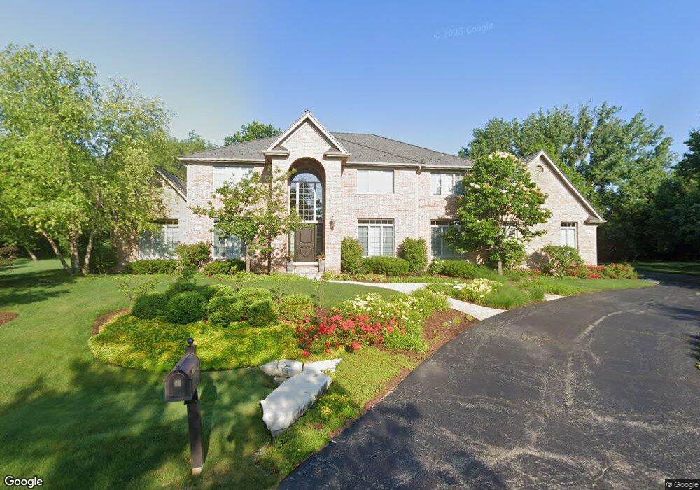
1770 Popp Ln Long Grove, IL 60047
Estimated Value: $1,000,000 - $1,206,000
--
Bed
4
Baths
4,473
Sq Ft
$256/Sq Ft
Est. Value
About This Home
This home is located at 1770 Popp Ln, Long Grove, IL 60047 and is currently estimated at $1,143,931, approximately $255 per square foot. 1770 Popp Ln is a home located in Lake County with nearby schools including Kildeer Countryside Elementary School, Woodlawn Middle School, and Adlai E Stevenson High School.
Ownership History
Date
Name
Owned For
Owner Type
Purchase Details
Closed on
Jul 18, 2005
Sold by
Donton Craig S and Donton Nanette K
Bought by
Donton Craig S and Craig S Donton 2004 Revocable
Current Estimated Value
Purchase Details
Closed on
Oct 6, 2003
Sold by
The Stephanie R Cohen Living Trust
Bought by
Donton Craig S and Donton Nanette K
Purchase Details
Closed on
Feb 6, 1999
Sold by
Cohen Isaac I and Cohen Stephanie R
Bought by
Cohen Stephanie R and Cohen Isaac I
Purchase Details
Closed on
Sep 20, 1996
Sold by
The Chicago Trust Company
Bought by
Cohen Stephanie R
Create a Home Valuation Report for This Property
The Home Valuation Report is an in-depth analysis detailing your home's value as well as a comparison with similar homes in the area
Home Values in the Area
Average Home Value in this Area
Purchase History
| Date | Buyer | Sale Price | Title Company |
|---|---|---|---|
| Donton Craig S | -- | -- | |
| Donton Craig S | $300,000 | -- | |
| Cohen Stephanie R | -- | -- | |
| Cohen Stephanie R | $145,000 | Chicago Title Insurance Co |
Source: Public Records
Tax History Compared to Growth
Tax History
| Year | Tax Paid | Tax Assessment Tax Assessment Total Assessment is a certain percentage of the fair market value that is determined by local assessors to be the total taxable value of land and additions on the property. | Land | Improvement |
|---|---|---|---|---|
| 2024 | $26,768 | $286,940 | $59,580 | $227,360 |
| 2023 | $21,772 | $279,233 | $57,980 | $221,253 |
| 2022 | $21,772 | $229,509 | $56,858 | $172,651 |
| 2021 | $20,734 | $223,628 | $55,401 | $168,227 |
| 2020 | $20,202 | $223,628 | $55,401 | $168,227 |
| 2019 | $22,835 | $257,650 | $54,918 | $202,732 |
| 2018 | $24,547 | $281,893 | $59,077 | $222,816 |
| 2017 | $24,074 | $279,779 | $59,649 | $220,130 |
| 2016 | $23,323 | $270,920 | $57,760 | $213,160 |
| 2015 | $23,184 | $257,045 | $53,313 | $203,732 |
| 2014 | $23,840 | $260,352 | $52,456 | $207,896 |
| 2012 | $23,459 | $268,081 | $52,566 | $215,515 |
Source: Public Records
Map
Nearby Homes
- 2426 Lexington Dr
- 1728 Holly Ct
- 2408 Cumberland Cir
- 1242 Antietam Dr
- 4220 Bonhill Dr Unit 3E
- 1545 Chickamauga Ln
- 1727 W Hawkes St Unit 8
- 4242 N Pheasant Trail Ct Unit 1
- 4210 N Mallard Dr Unit 4
- 1942 Trail Ridge St
- 1514 Sumter Dr
- 2246 N Baldwin Way Unit 1A
- 2263 N Enlund Dr Unit 1
- 1415 W Partridge Ln Unit 5
- 1631 W Partridge Ct Unit 8
- 906 E Kings Row Unit 1
- 1611 W Partridge Ct Unit 8
- 932 E Coach Rd Unit 8
- 1012 E Glavin Ct Unit 2A
- 2245 Nichols Rd Unit C
- 1766 Popp Ln
- 2560 Lincoln Ave
- 2562 Lincoln Ave
- 1772 Popp Ln
- 2558 Lincoln Ave
- 1764 Popp Ln
- 2564 Lincoln Ave
- 1769 Andrew Ct
- 1775 Andrew Ct
- 2561 Lincoln Ave
- 1762 Popp Ln
- 1749 Tanager Way
- 2559 Lincoln Ave
- 2563 Lincoln Ave Unit 2
- 1751 Tanager Way
- 1747 Tanager Way
- 2566 Lincoln Ave
- 2552 Shenandoah Ln
- 1760 Popp Ln
- 2565 Lincoln Ave