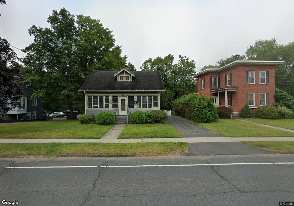
1771 Farmington Ave Unionville, CT 06085
Estimated Value: $362,149 - $441,000
3
Beds
2
Baths
1,560
Sq Ft
$259/Sq Ft
Est. Value
About This Home
This home is located at 1771 Farmington Ave, Unionville, CT 06085 and is currently estimated at $404,787, approximately $259 per square foot. 1771 Farmington Ave is a home located in Hartford County with nearby schools including Union School, West Woods Upper Elementary School, and Irving A. Robbins Middle School.
Ownership History
Date
Name
Owned For
Owner Type
Purchase Details
Closed on
May 10, 2024
Sold by
Maineri Albert J
Bought by
Albert J Maineri T J and Albert Allaire
Current Estimated Value
Purchase Details
Closed on
May 16, 2008
Sold by
Derick Neill A
Bought by
Maineri Albert J and Maineri Sandra C
Create a Home Valuation Report for This Property
The Home Valuation Report is an in-depth analysis detailing your home's value as well as a comparison with similar homes in the area
Home Values in the Area
Average Home Value in this Area
Purchase History
| Date | Buyer | Sale Price | Title Company |
|---|---|---|---|
| Albert J Maineri T J | -- | None Available | |
| Albert J Maineri T J | -- | None Available | |
| Maineri Albert J | $265,000 | -- | |
| Maineri Albert J | $265,000 | -- |
Source: Public Records
Mortgage History
| Date | Status | Borrower | Loan Amount |
|---|---|---|---|
| Previous Owner | Maineri Albert J | $100,000 | |
| Previous Owner | Maineri Albert J | $242,730 | |
| Previous Owner | Maineri Albert J | $97,000 |
Source: Public Records
Tax History Compared to Growth
Tax History
| Year | Tax Paid | Tax Assessment Tax Assessment Total Assessment is a certain percentage of the fair market value that is determined by local assessors to be the total taxable value of land and additions on the property. | Land | Improvement |
|---|---|---|---|---|
| 2025 | $4,890 | $183,680 | $67,340 | $116,340 |
| 2024 | $4,675 | $183,680 | $67,340 | $116,340 |
| 2023 | $4,447 | $183,680 | $67,340 | $116,340 |
| 2022 | $4,329 | $147,660 | $58,540 | $89,120 |
| 2021 | $4,254 | $147,660 | $58,540 | $89,120 |
| 2020 | $4,130 | $147,660 | $58,540 | $89,120 |
| 2019 | $4,130 | $147,660 | $58,540 | $89,120 |
| 2018 | $4,013 | $147,660 | $58,540 | $89,120 |
| 2017 | $3,654 | $136,970 | $54,240 | $82,730 |
| 2016 | $3,531 | $136,970 | $54,240 | $82,730 |
| 2015 | $3,426 | $136,970 | $54,240 | $82,730 |
| 2014 | $3,348 | $136,980 | $54,250 | $82,730 |
Source: Public Records
Map
Nearby Homes
- 55 Depot Place
- 31 Railroad Ave
- 243 New Britain Ave Unit 243
- 267 New Britain Ave
- 115 W Avon Rd
- 1622 Farmington Ave Unit 4
- 94 Sanford Ave
- 94 Perry St
- 3 Heritage Dr
- 27 Sherman Ave
- 54 Westview Terrace
- 148 River Rd
- 6 Burlington Rd
- 22 Heritage Dr Unit 22
- 2 Muirfield Ln
- 27 Westview Terrace
- 44 Applewood Ln Unit 44
- 8919 Taine Mountain Rd
- 54 Pinewood Dr
- 7 Newcastle Place
- 1773 Farmington Ave
- 1767 Farmington Ave
- 1777 Farmington Ave
- 1772 Farmington Ave
- 1772 Farmington Ave Unit 2
- 1772 Farmington Ave Unit 3
- 1766 Farmington Ave
- 1774 Farmington Ave
- 1776 Farmington Ave
- 1761 Farmington Ave
- 1781 Farmington Ave
- 1781 Farmington Ave
- 1762 Farmington Ave
- 1782 Farmington Ave
- 14 W Avon Rd
- 1755 Farmington Ave
- 24 Keyes St
- 20 Keyes St
- 30 Keyes St
- 1758 Farmington Ave