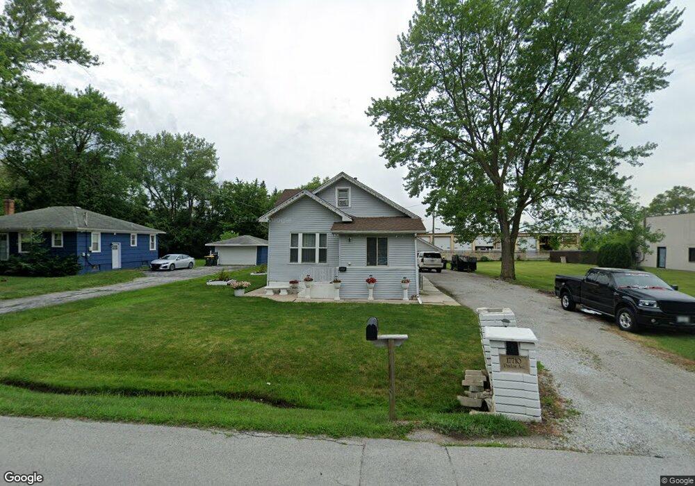
17710 Paxton Ave Lansing, IL 60438
Estimated Value: $179,000 - $191,000
4
Beds
1
Bath
1,200
Sq Ft
$156/Sq Ft
Est. Value
About This Home
This home is located at 17710 Paxton Ave, Lansing, IL 60438 and is currently estimated at $187,102, approximately $155 per square foot. 17710 Paxton Ave is a home located in Cook County with nearby schools including Oak Glen Elementary School, Memorial Jr High School, and Thornton Fractnl So High School.
Ownership History
Date
Name
Owned For
Owner Type
Purchase Details
Closed on
May 24, 2007
Sold by
Deboer Joan
Bought by
Pizano Ernesto and Meraz Jimenez Maria Lourdes
Current Estimated Value
Home Financials for this Owner
Home Financials are based on the most recent Mortgage that was taken out on this home.
Original Mortgage
$121,600
Outstanding Balance
$74,087
Interest Rate
6.2%
Mortgage Type
Unknown
Estimated Equity
$113,015
Create a Home Valuation Report for This Property
The Home Valuation Report is an in-depth analysis detailing your home's value as well as a comparison with similar homes in the area
Home Values in the Area
Average Home Value in this Area
Purchase History
| Date | Buyer | Sale Price | Title Company |
|---|---|---|---|
| Pizano Ernesto | $128,000 | Pntn |
Source: Public Records
Mortgage History
| Date | Status | Borrower | Loan Amount |
|---|---|---|---|
| Open | Pizano Ernesto | $121,600 |
Source: Public Records
Tax History Compared to Growth
Tax History
| Year | Tax Paid | Tax Assessment Tax Assessment Total Assessment is a certain percentage of the fair market value that is determined by local assessors to be the total taxable value of land and additions on the property. | Land | Improvement |
|---|---|---|---|---|
| 2024 | $4,637 | $12,901 | $4,820 | $8,081 |
| 2023 | $4,047 | $12,901 | $4,820 | $8,081 |
| 2022 | $4,047 | $9,648 | $4,253 | $5,395 |
| 2021 | $3,993 | $9,647 | $4,252 | $5,395 |
| 2020 | $3,840 | $9,647 | $4,252 | $5,395 |
| 2019 | $2,961 | $8,630 | $3,969 | $4,661 |
| 2018 | $2,903 | $8,630 | $3,969 | $4,661 |
| 2017 | $2,965 | $8,630 | $3,969 | $4,661 |
| 2016 | $3,054 | $8,083 | $3,685 | $4,398 |
| 2015 | $2,774 | $8,083 | $3,685 | $4,398 |
| 2014 | $2,763 | $8,083 | $3,685 | $4,398 |
| 2013 | $3,157 | $9,640 | $3,685 | $5,955 |
Source: Public Records
Map
Nearby Homes
- 1991 Indiana Ave
- 2216 177th St
- 17871 Locust St
- 2306 Holiday Terrace Unit 163
- 2306 Holiday Terrace Unit 149
- 2306 Holiday Terrace Unit 146
- 17934 Locust St
- 2237 175th St Unit 1B
- 2237 175th St Unit 2B
- 2307 177th St
- 2155 Bernice Rd
- 18038 Whitman Ln
- 2304 Holiday Terrace Unit 503
- 2304 Holiday Terrace Unit 303
- 17750 Clyde Ave
- 1555 Thornton Lansing Rd
- 18020 Ridgeland Ave
- 2201 Thornton Lansing Rd
- 18036 Crystal Ln
- 18049 Brittany Ln
- 17712 Paxton Ave
- 17704 Paxton Ave
- 17716 Paxton Ave
- 17711 Paxton Ave
- 17713 Paxton Ave
- 17715 Paxton Ave
- 17627 Paxton Ave
- 17611 Paxton Ave
- 17717 Paxton Ave
- 17720 Paxton Ave
- 17640 Paxton Ave
- 17727 Paxton Ave
- 17606 Paxton Ave
- 17737 Paxton Ave
- 17613 Paxton Ave
- 17724 Rosewood Dr
- 17747 Paxton Ave
- 17600 Paxton Ave
- 17757 Paxton Ave
- 17640 Rosewood Dr Unit 1D