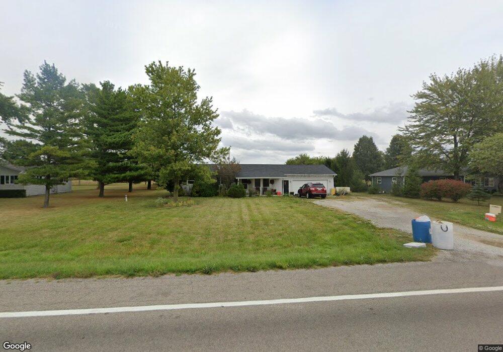
17712 State Route 196 Waynesfield, OH 45896
Estimated Value: $127,000 - $191,784
3
Beds
1
Bath
1,075
Sq Ft
$148/Sq Ft
Est. Value
About This Home
This home is located at 17712 State Route 196, Waynesfield, OH 45896 and is currently estimated at $159,196, approximately $148 per square foot. 17712 State Route 196 is a home located in Auglaize County with nearby schools including Waynesfield-Goshen Local Elementary School and Waynesfield-Goshen Local High School.
Ownership History
Date
Name
Owned For
Owner Type
Purchase Details
Closed on
Jul 15, 2021
Sold by
Fox Michael S and Fox Jennifer M
Bought by
Beebe Lisa
Current Estimated Value
Home Financials for this Owner
Home Financials are based on the most recent Mortgage that was taken out on this home.
Original Mortgage
$117,350
Outstanding Balance
$106,574
Interest Rate
2.96%
Mortgage Type
New Conventional
Estimated Equity
$52,622
Purchase Details
Closed on
Apr 10, 2012
Sold by
Sudener Timothy K and Sidener Susan A
Bought by
Fox Michael S and Fox Jennnifer M
Purchase Details
Closed on
Sep 13, 1991
Sold by
Hastings Merwyn B
Bought by
Sidener Timothy L
Create a Home Valuation Report for This Property
The Home Valuation Report is an in-depth analysis detailing your home's value as well as a comparison with similar homes in the area
Home Values in the Area
Average Home Value in this Area
Purchase History
| Date | Buyer | Sale Price | Title Company |
|---|---|---|---|
| Beebe Lisa | $116,200 | None Available | |
| Fox Michael S | $78,000 | Attorney | |
| Sidener Timothy L | $45,500 | -- |
Source: Public Records
Mortgage History
| Date | Status | Borrower | Loan Amount |
|---|---|---|---|
| Open | Beebe Lisa | $117,350 |
Source: Public Records
Tax History Compared to Growth
Tax History
| Year | Tax Paid | Tax Assessment Tax Assessment Total Assessment is a certain percentage of the fair market value that is determined by local assessors to be the total taxable value of land and additions on the property. | Land | Improvement |
|---|---|---|---|---|
| 2024 | $3,077 | $48,920 | $5,170 | $43,750 |
| 2023 | $1,732 | $48,920 | $5,170 | $43,750 |
| 2022 | $1,366 | $32,350 | $4,700 | $27,650 |
| 2021 | $1,353 | $32,350 | $4,700 | $27,650 |
| 2020 | $1,339 | $32,355 | $4,701 | $27,654 |
| 2019 | $1,090 | $26,961 | $3,917 | $23,044 |
| 2018 | $1,060 | $26,961 | $3,917 | $23,044 |
| 2017 | $1,070 | $26,961 | $3,917 | $23,044 |
| 2016 | $994 | $25,788 | $3,731 | $22,057 |
| 2015 | $959 | $25,788 | $3,731 | $22,057 |
| 2014 | $961 | $25,788 | $3,731 | $22,057 |
| 2013 | $1,066 | $25,788 | $3,731 | $22,057 |
Source: Public Records
Map
Nearby Homes
- 105 Guthrie St
- 202 W Mulberry St
- 25836 Ohio 67
- 22275 Buckland Holden Rd
- 8150 Amherst Rd
- 5065 Amherst Rd
- 20630 State Route 67
- 7165 Faulkner Rd
- 6616 Bellefontaine Rd
- 6381 McPheron Rd
- 17 E Walnut St
- 37 N Main St
- 0 Ohio 67
- E Hanthorn Rd
- 5600 E Hanthorn Rd
- 4160 E Hanthorn Rd
- 200 S Main St
- 1855 S Cool Rd
- 0 Ohio 235
- 11352 N Township Road 88
- 17674 State Route 196
- 17738 Ohio 196
- 17738 State Route 196
- 17650 State Route 196
- 17772 State Route 196
- 101 Sunrise Dr
- 526 N Westminster St
- 17772 Ohio 196
- 100 Sunrise Dr
- 535 N Westminster St
- 509 Morning Glory Dr
- 602 Morning Glory Dr
- 522 N Westminster St
- 17846 State Route 196
- 512 Morning Glory Dr
- 510 Morning Glory Dr
- 520 N Westminster St