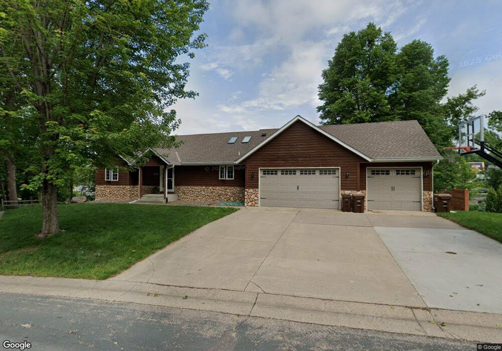
1773 Kestrel Cir Buffalo, MN 55313
Estimated Value: $490,000 - $582,989
3
Beds
2
Baths
1,188
Sq Ft
$446/Sq Ft
Est. Value
About This Home
This home is located at 1773 Kestrel Cir, Buffalo, MN 55313 and is currently estimated at $529,747, approximately $445 per square foot. 1773 Kestrel Cir is a home located in Wright County with nearby schools including Tatanka Elementary School, Buffalo Community Middle School, and Buffalo Senior High School.
Ownership History
Date
Name
Owned For
Owner Type
Purchase Details
Closed on
Aug 3, 2018
Sold by
Polman Kate Elizabeth
Bought by
Kramber Laura
Current Estimated Value
Home Financials for this Owner
Home Financials are based on the most recent Mortgage that was taken out on this home.
Original Mortgage
$185,000
Outstanding Balance
$160,665
Interest Rate
4.5%
Mortgage Type
New Conventional
Estimated Equity
$369,082
Purchase Details
Closed on
May 13, 2016
Sold by
Polman Anthony C
Bought by
Polman Kate Elizabeth
Purchase Details
Closed on
Mar 21, 2003
Sold by
Countryman Kevin E
Bought by
Polman Anthony C and Polman Lori A
Purchase Details
Closed on
Nov 13, 2000
Sold by
Durdahl Kenneth
Bought by
Countryman Kevin
Purchase Details
Closed on
Jun 26, 2000
Sold by
Estate Of Dale G Dixon
Bought by
Durdahl P Kenneth and Durdahl Construction
Create a Home Valuation Report for This Property
The Home Valuation Report is an in-depth analysis detailing your home's value as well as a comparison with similar homes in the area
Home Values in the Area
Average Home Value in this Area
Purchase History
| Date | Buyer | Sale Price | Title Company |
|---|---|---|---|
| Kramber Laura | $346,000 | Edina Realty Title Inc | |
| Polman Kate Elizabeth | -- | -- | |
| Polman Anthony C | $312,500 | -- | |
| Countryman Kevin | $180,000 | -- | |
| Durdahl P Kenneth | $2,000 | -- |
Source: Public Records
Mortgage History
| Date | Status | Borrower | Loan Amount |
|---|---|---|---|
| Open | Kramber Laura | $185,000 |
Source: Public Records
Tax History
| Year | Tax Paid | Tax Assessment Tax Assessment Total Assessment is a certain percentage of the fair market value that is determined by local assessors to be the total taxable value of land and additions on the property. | Land | Improvement |
|---|---|---|---|---|
| 2025 | $6,990 | $530,400 | $270,000 | $260,400 |
| 2024 | $6,680 | $516,700 | $270,000 | $246,700 |
| 2023 | $6,274 | $515,600 | $270,000 | $245,600 |
| 2022 | $5,650 | $449,700 | $225,000 | $224,700 |
| 2021 | $5,566 | $368,100 | $170,000 | $198,100 |
| 2020 | $5,632 | $355,200 | $170,000 | $185,200 |
| 2019 | $5,904 | $346,800 | $0 | $0 |
| 2018 | $5,588 | $380,000 | $0 | $0 |
| 2017 | $5,462 | $356,200 | $0 | $0 |
| 2016 | $5,166 | $0 | $0 | $0 |
| 2015 | $4,786 | $0 | $0 | $0 |
| 2014 | -- | $0 | $0 | $0 |
Source: Public Records
Map
Nearby Homes
- 1716 Ibis Dr
- 1906 Hawk Trail
- 2207 Robin Ln
- 2102 Whitetail Run
- 2627 Arbor Dr
- 2615 Arbor Dr
- 2408 Meadow Dr
- 2097 Coneflower Point
- 212 Greenbriar Ln
- 2422 Buffalo Ridge Dr
- 2017 Coneflower Point
- 1430 Pulaski Rd
- 2629 Buffalo Ridge Dr
- 2707 Buffalo Ridge Dr
- 2614 Buffalo Ridge Dr
- 203 Douglas Dr
- 2560 Buffalo Ridge Dr
- 4174 Braddock Ave NE
- 2840 30th St NE
- 112 Lilac Ct
- XX1 Kestrel Cir
- XX2 Kestrel Cir
- 1777 Kestrel Cir
- 1732 Kestrel Cir
- 1724 Kestrel Cir
- 1711 Ibis Dr
- 2605 Ibis Way
- 1707 Ibis Dr
- 1781 Kestrel Cir
- 2XXX Kestrel Trail
- 1705 Ibis Dr
- 1720 Kestrel Cir
- 1712 Ibis Dr
- 1706 Ibis Dr
- 2621 Cardinal Way
- 1757 Kestrel Cir
- 1701 Ibis Dr
- 1801 Kestrel Cir Unit 4
- 2621 Kestrel Ct
- 1716 Kestrel Cir
Your Personal Tour Guide
Ask me questions while you tour the home.