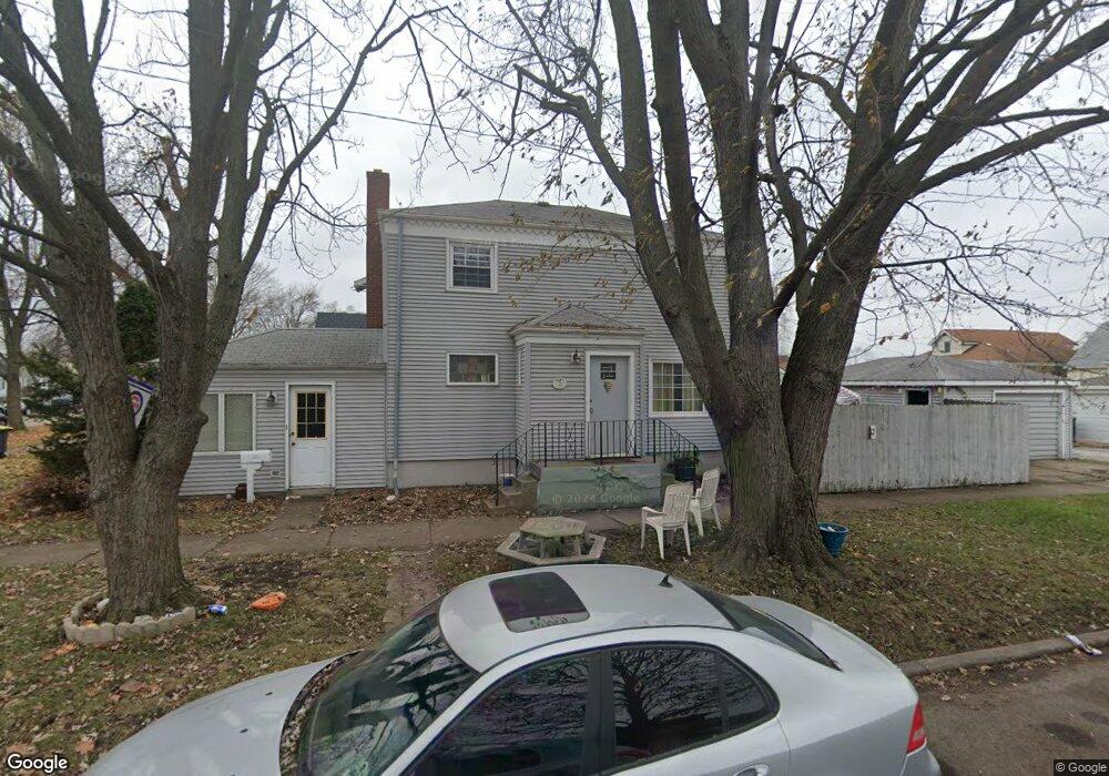
17756 Maple St Lansing, IL 60438
Estimated Value: $185,000 - $214,000
3
Beds
2
Baths
1,134
Sq Ft
$174/Sq Ft
Est. Value
About This Home
This home is located at 17756 Maple St, Lansing, IL 60438 and is currently estimated at $196,915, approximately $173 per square foot. 17756 Maple St is a home located in Cook County with nearby schools including Coolidge Elementary School, Memorial Jr High School, and Thornton Fractnl So High School.
Ownership History
Date
Name
Owned For
Owner Type
Purchase Details
Closed on
Dec 20, 2010
Sold by
Phillips Brian
Bought by
Whitewing Sandra A
Current Estimated Value
Home Financials for this Owner
Home Financials are based on the most recent Mortgage that was taken out on this home.
Original Mortgage
$124,992
Outstanding Balance
$53,103
Interest Rate
4.44%
Mortgage Type
New Conventional
Estimated Equity
$143,812
Purchase Details
Closed on
Oct 18, 2001
Sold by
Phillips Brian and Phillips Jennifer
Bought by
Phillips Brian
Purchase Details
Closed on
May 18, 1998
Sold by
Visser Henry F and Visser Nancy J
Bought by
Phillips Brian R and Phillips Jennifer A
Home Financials for this Owner
Home Financials are based on the most recent Mortgage that was taken out on this home.
Original Mortgage
$97,239
Interest Rate
7.19%
Mortgage Type
FHA
Create a Home Valuation Report for This Property
The Home Valuation Report is an in-depth analysis detailing your home's value as well as a comparison with similar homes in the area
Home Values in the Area
Average Home Value in this Area
Purchase History
| Date | Buyer | Sale Price | Title Company |
|---|---|---|---|
| Whitewing Sandra A | $80,000 | Attorneys Title Guaranty Fun | |
| Phillips Brian | -- | -- | |
| Phillips Brian R | $98,000 | -- |
Source: Public Records
Mortgage History
| Date | Status | Borrower | Loan Amount |
|---|---|---|---|
| Open | Whitewing Sandra A | $124,992 | |
| Previous Owner | Phillips Brian R | $97,239 |
Source: Public Records
Tax History
| Year | Tax Paid | Tax Assessment Tax Assessment Total Assessment is a certain percentage of the fair market value that is determined by local assessors to be the total taxable value of land and additions on the property. | Land | Improvement |
|---|---|---|---|---|
| 2025 | $5,169 | $14,000 | $1,417 | $12,583 |
| 2024 | $5,169 | $14,000 | $1,417 | $12,583 |
| 2023 | $5,131 | $14,000 | $1,417 | $12,583 |
| 2022 | $5,131 | $11,316 | $1,251 | $10,065 |
| 2021 | $5,048 | $11,315 | $1,250 | $10,065 |
| 2020 | $4,818 | $11,315 | $1,250 | $10,065 |
| 2019 | $4,590 | $11,491 | $1,167 | $10,324 |
| 2018 | $4,501 | $11,491 | $1,167 | $10,324 |
| 2017 | $6,483 | $11,491 | $1,167 | $10,324 |
| 2016 | $5,168 | $9,452 | $1,083 | $8,369 |
| 2015 | $4,802 | $9,452 | $1,083 | $8,369 |
| 2014 | $4,736 | $9,452 | $1,083 | $8,369 |
| 2013 | $4,765 | $10,582 | $1,083 | $9,499 |
Source: Public Records
Map
Nearby Homes
- 3645 177th Place
- 108 Beverly Place
- 3520 Jackson St
- 17702 Bernadine St
- 17945 Maple St
- 3617 Monroe St
- 7937 Forest Ave
- 3659 Madison St
- 17913 William St
- 222 Beacon Place
- 3522 Washington St
- 8039 Forest Ave
- 17831 Community St
- 222 Broadmoor Ave
- 17821 Roy St
- 17614 Community St
- 18158 Lange St
- 17519 Community St
- 3527 Lake St
- 3238 178th St
- 3662 178th St
- 3658 178th St
- 3658 178th St
- 3654 178th St
- 3654 178th St
- 3671 177th Place
- 3669 177th Place
- 17747 Maple St
- 17753 Maple St
- 3665 177th Place
- 17741 Maple St
- 3661 177th Place
- 3650 178th St
- 3657 177th Place
- 3669 178th St
- 17801 Maple St
- 3665 178th St
- 3646 178th St
- 3646 178th St
- 3653 177th Place
Your Personal Tour Guide
Ask me questions while you tour the home.