Estimated Value: $182,000 - $219,000
3
Beds
2
Baths
1,452
Sq Ft
$141/Sq Ft
Est. Value
About This Home
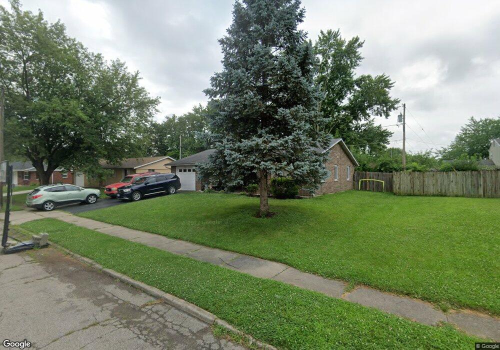
This home is located at 1777 Maumee Dr, Xenia, OH 45385 and is currently estimated at $204,116, approximately $140 per square foot. 1777 Maumee Dr is a home located in Greene County with nearby schools including Xenia High School, Summit Academy Community School for Alternative Learners - Xenia, and Legacy Christian Academy.
Ownership History
Date
Name
Owned For
Owner Type
Purchase Details
Closed on
Apr 29, 2010
Sold by
Federal Home Loan Mortgage Corporation
Bought by
Ohio Valley Property Management Llc
Current Estimated Value
Purchase Details
Closed on
Apr 2, 2010
Sold by
Moore Billy R and Moore Patricia A
Bought by
Federal Home Loan Mortgage Corporation
Purchase Details
Closed on
Oct 17, 1996
Sold by
Spradlin Susan K
Bought by
Moore Billy R and Moore A
Home Financials for this Owner
Home Financials are based on the most recent Mortgage that was taken out on this home.
Original Mortgage
$79,755
Interest Rate
8.44%
Mortgage Type
FHA
Create a Home Valuation Report for This Property
The Home Valuation Report is an in-depth analysis detailing your home's value as well as a comparison with similar homes in the area
Home Values in the Area
Average Home Value in this Area
Purchase History
| Date | Buyer | Sale Price | Title Company |
|---|---|---|---|
| Ohio Valley Property Management Llc | $69,900 | Attorney | |
| Federal Home Loan Mortgage Corporation | $70,000 | Attorney | |
| Moore Billy R | $80,000 | -- |
Source: Public Records
Mortgage History
| Date | Status | Borrower | Loan Amount |
|---|---|---|---|
| Previous Owner | Moore Billy R | $79,755 |
Source: Public Records
Tax History Compared to Growth
Tax History
| Year | Tax Paid | Tax Assessment Tax Assessment Total Assessment is a certain percentage of the fair market value that is determined by local assessors to be the total taxable value of land and additions on the property. | Land | Improvement |
|---|---|---|---|---|
| 2024 | $2,442 | $57,080 | $10,040 | $47,040 |
| 2023 | $2,442 | $57,080 | $10,040 | $47,040 |
| 2022 | $2,057 | $41,010 | $5,900 | $35,110 |
| 2021 | $2,085 | $41,010 | $5,900 | $35,110 |
| 2020 | $1,998 | $41,010 | $5,900 | $35,110 |
| 2019 | $1,741 | $33,650 | $6,130 | $27,520 |
| 2018 | $1,748 | $33,650 | $6,130 | $27,520 |
| 2017 | $1,588 | $33,650 | $6,130 | $27,520 |
| 2016 | $1,588 | $30,000 | $6,130 | $23,870 |
| 2015 | $1,593 | $30,000 | $6,130 | $23,870 |
| 2014 | $1,525 | $30,000 | $6,130 | $23,870 |
Source: Public Records
Map
Nearby Homes
- 1778 Arapaho Dr
- 1618 Navajo Dr
- 1769 Gayhart Dr
- 1829 Gayhart Dr
- 1653 Seneca Dr
- 1866 Roxbury Dr
- 1272 Bellbrook Ave
- 1908 Whitt St
- 1208 Bellbrook Ave
- 1255 Colorado Dr
- 1568 Cheyenne Dr
- 1144 Rockwell Dr
- 1107 Arkansas Dr
- 2758 Wyoming Dr
- 2142 Michigan Dr
- 2257 Maryland Dr
- 161 Montana Dr
- 414 Whisper Ln
- 2499 Jenny Marie Dr
- 219 Kansas Dr
- 1763 Maumee Dr
- 1795 Maumee Dr
- 1766 Arapaho Dr
- 1782 Arapaho Dr
- 1772 Maumee Dr
- 1751 Maumee Dr
- 1754 Maumee Dr
- 1790 Maumee Dr
- 1746 Arapaho Dr
- 1739 Maumee Dr
- 1742 Maumee Dr
- 1832 Arapaho Dr
- 1787 Pueblo Dr
- 1791 Arapaho Dr
- 1726 Arapaho Dr
- 1781 Sioux Dr
- 1804 Sioux Dr
- 1773 Pueblo Dr
- 1805 Arapaho Dr
- 1725 Maumee Dr