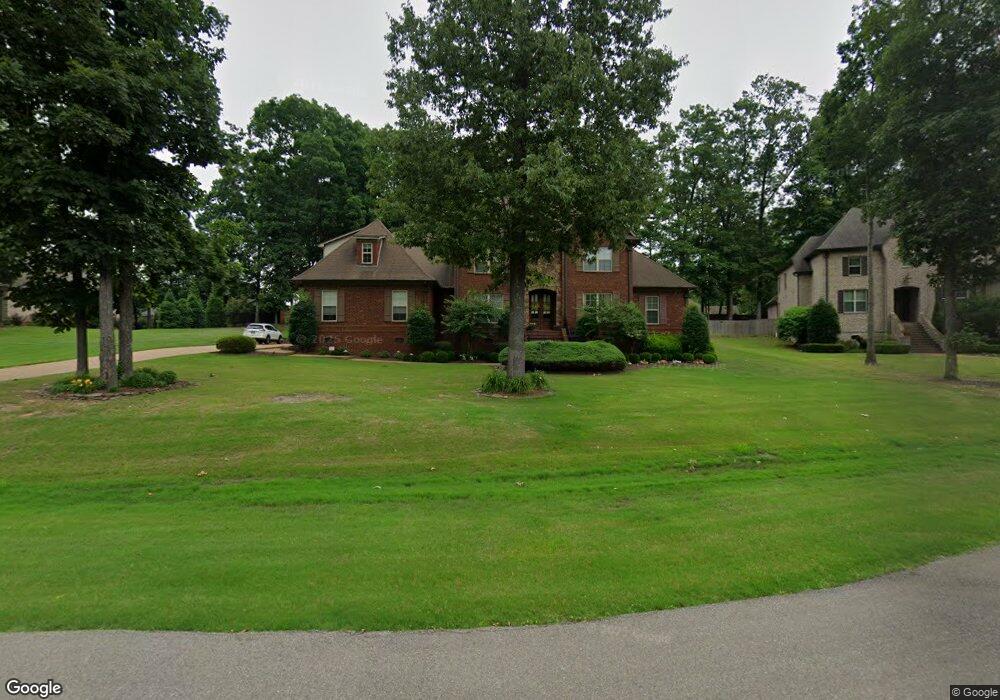
1778 Atticus Ln Nesbit, MS 38651
Pleasant Hill NeighborhoodEstimated Value: $527,000 - $679,000
5
Beds
5
Baths
4,029
Sq Ft
$146/Sq Ft
Est. Value
About This Home
This home is located at 1778 Atticus Ln, Nesbit, MS 38651 and is currently estimated at $588,621, approximately $146 per square foot. 1778 Atticus Ln is a home located in DeSoto County with nearby schools including DeSoto Central Primary School, DeSoto Central Elementary School, and DeSoto Central Middle School.
Ownership History
Date
Name
Owned For
Owner Type
Purchase Details
Closed on
Sep 23, 2008
Sold by
Napier Landreth Homes Llc
Bought by
Copeland Weldon L and Copeland Catherine A
Current Estimated Value
Home Financials for this Owner
Home Financials are based on the most recent Mortgage that was taken out on this home.
Original Mortgage
$160,000
Interest Rate
6.49%
Mortgage Type
Purchase Money Mortgage
Create a Home Valuation Report for This Property
The Home Valuation Report is an in-depth analysis detailing your home's value as well as a comparison with similar homes in the area
Home Values in the Area
Average Home Value in this Area
Purchase History
| Date | Buyer | Sale Price | Title Company |
|---|---|---|---|
| Copeland Weldon L | -- | None Available |
Source: Public Records
Mortgage History
| Date | Status | Borrower | Loan Amount |
|---|---|---|---|
| Closed | Copeland Weldon L | $160,000 |
Source: Public Records
Tax History
| Year | Tax Paid | Tax Assessment Tax Assessment Total Assessment is a certain percentage of the fair market value that is determined by local assessors to be the total taxable value of land and additions on the property. | Land | Improvement |
|---|---|---|---|---|
| 2025 | $2,457 | $36,923 | $5,000 | $31,923 |
| 2024 | $2,971 | $36,923 | $5,000 | $31,923 |
| 2023 | $2,971 | $36,923 | $0 | $0 |
| 2022 | $2,971 | $36,923 | $5,000 | $31,923 |
| 2021 | $3,428 | $36,923 | $5,000 | $31,923 |
| 2020 | $3,177 | $34,432 | $5,000 | $29,432 |
| 2019 | $3,177 | $34,432 | $5,000 | $29,432 |
| 2017 | $3,416 | $68,076 | $36,538 | $31,538 |
| 2016 | $3,416 | $36,538 | $5,000 | $31,538 |
| 2015 | $3,716 | $68,076 | $36,538 | $31,538 |
| 2014 | $3,379 | $36,538 | $0 | $0 |
| 2013 | $3,379 | $36,538 | $0 | $0 |
Source: Public Records
Map
Nearby Homes
- 3049 Pleasant Hill Rd
- 1768 Linden Dr
- 3456 Susie Cir
- 2065 Owl Wing Place
- 401 Getwell Rd
- 403 Getwell Rd
- 3040 Highground Dr
- 2768 Black Rock Rd
- 3060 Highground Dr
- 3491 Hatton Dr
- 1777 Starlanding Rd E
- 3250 W Hartland Dr
- 2255 Highground Dr
- 3505 Kreunen St
- 2239 Highground Dr
- 1623 Imboden Cove
- 2225 Highground Dr
- 2195 Highground Dr
- 4007 Bakersfield Dr
- 3621 Hatton Dr
- 1754 Atticus Ln
- 2585 Atticus Ln
- 1791 Atticus Ln
- 2550 Atticus Ln
- 1823 Atticus Ln
- 4818 Bakers Trail E
- 4836 Bakers Trail E
- 4864 Bakers Trail E
- 4887 Bakers Trail E
- 4823 Bakers Trail E
- 4804 Bakers Trail E
- 4887 Bakers Trail E
- 4875 Bakers Trail E
- 4857 Bakers Trail E
- 4882 Bakers Trail E
- 1758 Atticus Ln
- 2598 Atticus Ln
- 2557 Jem St
- 1781 Scout Cove
- 1807 Scout Cove
Your Personal Tour Guide
Ask me questions while you tour the home.