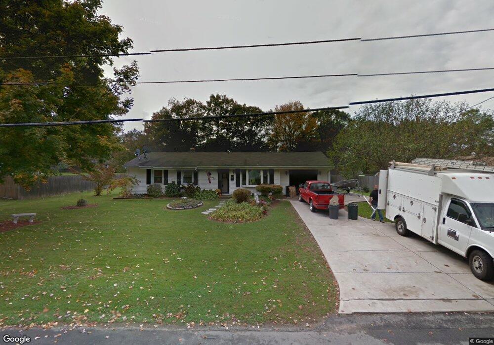
178 Burnside Dr Swansea, MA 02777
Luther Corner NeighborhoodEstimated Value: $396,000 - $469,000
3
Beds
1
Bath
1,008
Sq Ft
$440/Sq Ft
Est. Value
About This Home
This home is located at 178 Burnside Dr, Swansea, MA 02777 and is currently estimated at $443,386, approximately $439 per square foot. 178 Burnside Dr is a home located in Bristol County with nearby schools including Joseph Case High School, Highlander Charter Middle and High School, and East Bay Career Academy.
Ownership History
Date
Name
Owned For
Owner Type
Purchase Details
Closed on
Oct 14, 1982
Bought by
Heywood Michael S and Heywood Mariann P
Current Estimated Value
Create a Home Valuation Report for This Property
The Home Valuation Report is an in-depth analysis detailing your home's value as well as a comparison with similar homes in the area
Home Values in the Area
Average Home Value in this Area
Purchase History
| Date | Buyer | Sale Price | Title Company |
|---|---|---|---|
| Heywood Michael S | -- | -- |
Source: Public Records
Mortgage History
| Date | Status | Borrower | Loan Amount |
|---|---|---|---|
| Open | Heywood Michael S | $25,000 | |
| Closed | Heywood Michael S | $18,000 | |
| Closed | Heywood Michael S | $75,000 |
Source: Public Records
Tax History Compared to Growth
Tax History
| Year | Tax Paid | Tax Assessment Tax Assessment Total Assessment is a certain percentage of the fair market value that is determined by local assessors to be the total taxable value of land and additions on the property. | Land | Improvement |
|---|---|---|---|---|
| 2025 | $3,910 | $328,000 | $152,000 | $176,000 |
| 2024 | $3,897 | $325,000 | $152,000 | $173,000 |
| 2023 | $3,674 | $279,800 | $111,000 | $168,800 |
| 2022 | $3,636 | $252,700 | $101,000 | $151,700 |
| 2021 | $3,398 | $217,400 | $101,000 | $116,400 |
| 2020 | $3,449 | $221,400 | $101,000 | $120,400 |
| 2019 | $3,260 | $210,200 | $89,800 | $120,400 |
| 2018 | $3,117 | $204,000 | $87,700 | $116,300 |
| 2017 | $2,709 | $204,000 | $87,700 | $116,300 |
| 2016 | $2,536 | $187,600 | $75,700 | $111,900 |
| 2015 | $2,315 | $176,300 | $75,700 | $100,600 |
| 2014 | $2,282 | $177,700 | $75,700 | $102,000 |
Source: Public Records
Map
Nearby Homes
- 147 Bushee Rd
- 46 Magnolia Dr
- 1405 Gar Hwy Unit A
- 447 Old Warren Rd
- 192 Schoolhouse Rd
- 0 Old Fall River Rd Unit 73399047
- 9 Kenny Dr
- 79 Cedar Ave
- 17 Colonial Dr
- 34 Columbia Rd
- 107 & 107R Walker
- 510 Child St Unit 303A
- 510 Child St Unit 105B
- 510 Child St Unit 201C
- 510 Child St Unit 402B
- 510 Child St Unit 305B
- 24 Nod Rd
- 383 Vinnicum Rd
- 25 Asylum Rd
- 210 Metacom Ave
- 170 Burnside Dr
- 186 Burnside Dr
- 74 Smoke Rise Cir
- 82 Smoke Rise Cir
- 66 Smoke Rise Cir
- 162 Burnside Dr
- 175 Burnside Dr
- 183 Burnside Dr
- 90 Smoke Rise Cir
- 167 Burnside Dr
- 191 Burnside Dr
- 204 Burnside Dr
- 154 Burnside Dr
- 102 Smoke Rise Cir
- 9 Ash Rd
- 159 Burnside Dr
- 199 Burnside Dr
- 71 Smoke Rise Cir
- 83 Smoke Rise Cir
- 67 Smoke Rise Cir