


178 S Worcester St Norton, MA 02766
Estimated payment $4,593/month
Highlights
- Golf Course Community
- Medical Services
- Waterfront
- Public Water Access
- In Ground Pool
- 4.1 Acre Lot
About This Home
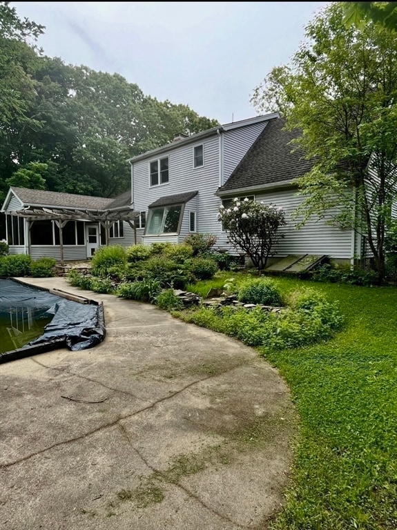
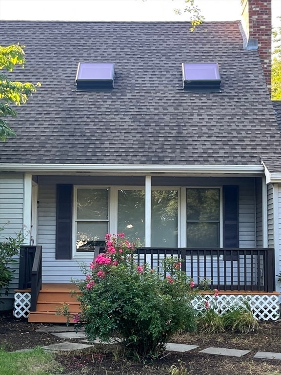
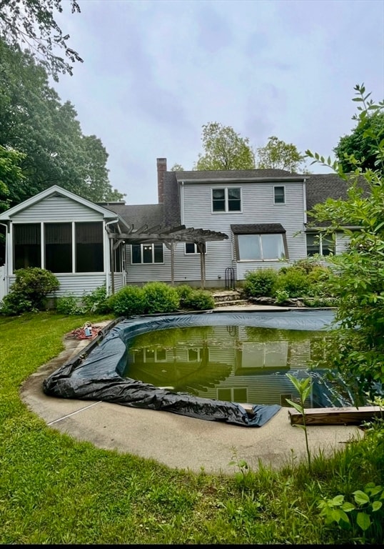
CUSTOM BUILT CAPE sits on a 4.1 ACRE LOT Setting is off the road Borders Barrowsville Pond , Camelot front porch , Nicely landscaped ,perennial bushes and plants , Gunite Pool , Fenced in yard , Screened in attached porch overlooking rear yard , Lofted room overlooks fireplaced living room . Floor to Ceiling fireplace , Plenty of skylights for natural light , many closets and storage , full finished basement w/ 2 utility rooms and office , **heating system is a wood/ coal/ oil furnace **, shelf and closet built ins , wood floors on 2 main levels , basement offers finished rooms , sep utility rooms , 2 car garage w/garage door openers n access to interior , Abuts Barrowvilles Pond ......Your .Private.Overgrown Pathway to access Barrowsville Pond (Bring your canoe , Your kayak , Your chair to enjoy nature -TRULY A MUST SEE

Home Details
Home Type
- Single Family
Est. Annual Taxes
- $7,763
Year Built
- Built in 1984
Lot Details
- 4.1 Acre Lot
- Waterfront
- Fenced Yard
- Level Lot
- Wooded Lot
- Property is zoned R60
Parking
- 2 Car Attached Garage
- Parking Storage or Cabinetry
- Tandem Parking
- Garage Door Opener
- Driveway
- Open Parking
- Off-Street Parking
Home Design
- Cape Cod Architecture
- Frame Construction
- Shingle Roof
- Concrete Perimeter Foundation
Interior Spaces
- 2,153 Sq Ft Home
- Open Floorplan
- Central Vacuum
- Cathedral Ceiling
- Ceiling Fan
- Skylights
- Recessed Lighting
- Decorative Lighting
- Light Fixtures
- Insulated Windows
- Bay Window
- Window Screens
- Sliding Doors
- Entryway
- Great Room
- Living Room with Fireplace
- Dining Area
- Home Office
- Loft
- Screened Porch
- Storage Room
Kitchen
- Range
- Dishwasher
- Solid Surface Countertops
Flooring
- Wood
- Wall to Wall Carpet
- Ceramic Tile
Bedrooms and Bathrooms
- 3 Bedrooms
- Primary Bedroom on Main
- Custom Closet System
- Dual Closets
- Walk-In Closet
- 2 Full Bathrooms
Laundry
- Laundry on main level
- Laundry in Bathroom
- Washer and Electric Dryer Hookup
Finished Basement
- Basement Fills Entire Space Under The House
- Interior and Exterior Basement Entry
- Block Basement Construction
Outdoor Features
- In Ground Pool
- Public Water Access
- Bulkhead
- Deck
- Patio
- Rain Gutters
Location
- Property is near public transit
- Property is near schools
Schools
- Jc Solomonese Elementary School
- Norton Middle School
- Norton High School
Utilities
- Cooling Available
- Heating System Uses Oil
- Baseboard Heating
- 200+ Amp Service
- Electric Water Heater
- Private Sewer
- High Speed Internet
- Cable TV Available
Listing and Financial Details
- Assessor Parcel Number M:27 P:11003,2925505
Community Details
Overview
- No Home Owners Association
- Near Conservation Area
Amenities
- Medical Services
- Shops
- Coin Laundry
Recreation
- Golf Course Community
- Park
- Jogging Path
- Bike Trail
Map
Home Values in the Area
Average Home Value in this Area
Tax History
| Year | Tax Paid | Tax Assessment Tax Assessment Total Assessment is a certain percentage of the fair market value that is determined by local assessors to be the total taxable value of land and additions on the property. | Land | Improvement |
|---|---|---|---|---|
| 2025 | $78 | $598,500 | $197,500 | $401,000 |
| 2024 | $7,454 | $575,600 | $188,100 | $387,500 |
| 2023 | $7,059 | $543,400 | $177,300 | $366,100 |
| 2022 | $6,819 | $478,200 | $161,100 | $317,100 |
| 2021 | $6,438 | $431,200 | $153,500 | $277,700 |
| 2020 | $6,253 | $422,500 | $149,000 | $273,500 |
| 2019 | $5,957 | $399,800 | $136,200 | $263,600 |
| 2018 | $5,646 | $372,400 | $136,200 | $236,200 |
| 2017 | $5,509 | $358,400 | $136,200 | $222,200 |
| 2016 | $5,298 | $339,400 | $136,200 | $203,200 |
| 2015 | $5,089 | $330,700 | $132,400 | $198,300 |
| 2014 | $4,888 | $318,000 | $126,100 | $191,900 |
Property History
| Date | Event | Price | List to Sale | Price per Sq Ft |
|---|---|---|---|---|
| 07/17/2025 07/17/25 | For Sale | $750,000 | -- | $348 / Sq Ft |
Purchase History
| Date | Type | Sale Price | Title Company |
|---|---|---|---|
| Deed | -- | -- | |
| Deed | -- | -- |
Source: MLS Property Information Network (MLS PIN)
MLS Number: 73405979
APN: NORT-000027-000000-000110-000003
Disclaimer: Certain information contained herein is derived from information provided by parties other than Homes.com. All information provided is deemed reliable, but is not guaranteed to be accurate and should be independently verified.
![]() The property listing data and information, or the Images, set forth herein were provided to MLS Property Information Network, Inc. from third party sources, including sellers, lessors and public records, and were compiled by MLS Property Information Network, Inc. The property listing data and information, and the Images, are for the personal, non-commercial use of consumers having a good faith interest in purchasing or leasing listed properties of the type displayed to them and may not be used for any purpose other than to identify prospective properties which such consumers may have a good faith interest in purchasing or leasing. MLS Property Information Network, Inc. and its subscribers disclaim any and all representations and warranties as to the accuracy of the property listing data and information, or as to the accuracy of any of the Images, set forth herein.
The property listing data and information, or the Images, set forth herein were provided to MLS Property Information Network, Inc. from third party sources, including sellers, lessors and public records, and were compiled by MLS Property Information Network, Inc. The property listing data and information, and the Images, are for the personal, non-commercial use of consumers having a good faith interest in purchasing or leasing listed properties of the type displayed to them and may not be used for any purpose other than to identify prospective properties which such consumers may have a good faith interest in purchasing or leasing. MLS Property Information Network, Inc. and its subscribers disclaim any and all representations and warranties as to the accuracy of the property listing data and information, or as to the accuracy of any of the Images, set forth herein.
- 170 S Worcester St Unit 3
- 145 S Worcester St
- 225 S Worcester St Unit 1
- 225 S Worcester St Unit 2
- 75 Barrows St
- 26 Dean St
- 108 S Worcester St
- 38 Danielle St
- 48 Dean St
- 127 John Scott Blvd
- 125 John Scott Blvd
- 16 Park Ln
- 55 Sturdy St
- 53 Sturdy St
- 4 Colonial Dr Unit 4
- 3 Lloyd Cir Unit 43
- 20 Lloyd Cir Unit 32
- 18 Lloyd Cir Unit 31
- 14 Lloyd Cir Unit 29
- 3 Gilberts Way
- 207 John Scott Blvd Unit B
- 5 N Worcester St
- 195 Mansfield Ave
- 1101 Hillside Ave
- 92 Emory St Unit 1
- 72 Forest St Unit 2
- 11 Starkey Ave Unit 2
- 75 Thacher Brook Cir
- 41 Emory St Unit 3
- 45 Oakdale St
- 31 Holman St Unit 3
- 280 S Washington St
- 25 Holman St Unit 3
- 4 Howard Ave Unit 2
- 274 E Main St
- 10 Holman St Unit C
- 95 Park St Unit 4
- 95 Park St Unit 3
- 95 Park St Unit 1
- 95 Park St Unit 2