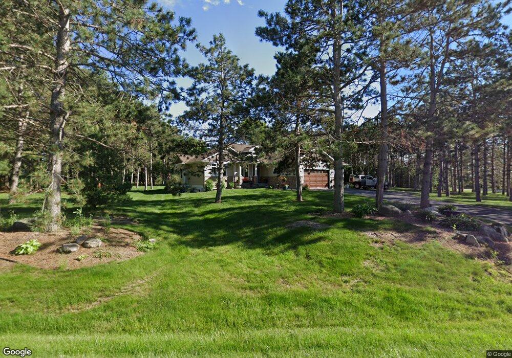
1780 Saint Andrews Place New Richmond, WI 54017
Estimated Value: $551,000 - $672,292
4
Beds
3
Baths
--
Sq Ft
1.47
Acres
About This Home
This home is located at 1780 Saint Andrews Place, New Richmond, WI 54017 and is currently estimated at $613,573. 1780 Saint Andrews Place is a home located in St. Croix County with nearby schools including New Richmond High School and St. Mary School.
Ownership History
Date
Name
Owned For
Owner Type
Purchase Details
Closed on
Oct 1, 2025
Sold by
Gary H And Bonnie F Baillargeon Living T and Baillargeon Daniel S
Bought by
James Kelly Stephens And Gwen C Stephens Livi and Stephens
Current Estimated Value
Purchase Details
Closed on
Oct 28, 2011
Sold by
Salewski Sheryelann Marie and Hanuman Sheryelann M
Bought by
Baillargeon Gary H and Baillargeon Bonnie F
Purchase Details
Closed on
Jul 7, 2010
Sold by
Kinny Randy L and Kinny Lori H
Bought by
Salewski Sheryelann Marie
Create a Home Valuation Report for This Property
The Home Valuation Report is an in-depth analysis detailing your home's value as well as a comparison with similar homes in the area
Home Values in the Area
Average Home Value in this Area
Purchase History
| Date | Buyer | Sale Price | Title Company |
|---|---|---|---|
| James Kelly Stephens And Gwen C Stephens Livi | $690,000 | None Listed On Document | |
| Baillargeon Gary H | $265,000 | Northwest Title Agency | |
| Salewski Sheryelann Marie | $377,000 | River Valley Abstract & Titl |
Source: Public Records
Tax History Compared to Growth
Tax History
| Year | Tax Paid | Tax Assessment Tax Assessment Total Assessment is a certain percentage of the fair market value that is determined by local assessors to be the total taxable value of land and additions on the property. | Land | Improvement |
|---|---|---|---|---|
| 2024 | $87 | $576,500 | $110,900 | $465,600 |
| 2023 | $8,334 | $561,300 | $110,900 | $450,400 |
| 2022 | $7,192 | $497,700 | $110,900 | $386,800 |
| 2021 | $7,094 | $452,300 | $110,900 | $341,400 |
| 2020 | $7,269 | $294,200 | $92,100 | $202,100 |
| 2019 | $6,896 | $294,200 | $92,100 | $202,100 |
| 2018 | $6,890 | $294,200 | $92,100 | $202,100 |
| 2017 | $6,649 | $294,200 | $92,100 | $202,100 |
| 2016 | $6,649 | $294,200 | $92,100 | $202,100 |
| 2015 | $6,738 | $294,200 | $92,100 | $202,100 |
| 2014 | $6,592 | $294,200 | $92,100 | $202,100 |
| 2013 | $6,455 | $294,200 | $92,100 | $202,100 |
Source: Public Records
Map
Nearby Homes
- 1787 Saint Andrews Place
- 1777 George Norman Dr
- 1206 Pinecrest Rd
- 1176 Carroll St
- 1418 Bluff Border Rd
- XXXX 110th St
- 1142 W Edge Place
- 305 S Pierson Ave
- 941 W Edge Place Unit 14
- 1016 W Ridge Ct
- 1337 Eagle Ct
- 1256 195th Ave
- 1705 107th St
- 1272 Pheasant Run
- XXX 140th Ave
- 637 Maple Ct
- 1561 Creekwood Dr
- 1539 Creekwood Dr
- Hudson Plan at The Creek at Gloverdale
- Kenny Plan at The Creek at Gloverdale
- 11 & 12 Cty Road K
- 0 Cty Road K Unit 4337432
- 1771 Saint Andrews Place
- 1773 Saint Andrews Place
- 1773 Saint Andrew's Place
- 274 County Road K
- 1781 Saint Andrews Place
- 1775 Saint Andrews Place
- 262 County Road K
- 1775 Saint Andrew's Place
- 1779 Saint Andrews Place
- 1785 Saint Andrews Place
- 1757 Saint Andrew's Place
- 1757 Saint Andrews Place
- Lot 5 Saint Andrew's Place
- 1775 George Norman Dr Unit 1
- 1775 George Norman Dr
- 1769 George Norman Dr Unit 8
- 1771 George Norman Dr
- 1773 George Norman Dr Unit 6