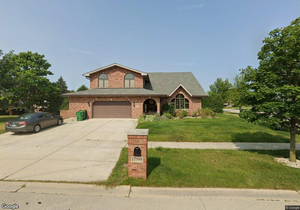
17800 Woburn Rd Tinley Park, IL 60487
Central Tinley Park NeighborhoodEstimated Value: $538,000 - $636,000
4
Beds
3
Baths
3,315
Sq Ft
$178/Sq Ft
Est. Value
About This Home
This home is located at 17800 Woburn Rd, Tinley Park, IL 60487 and is currently estimated at $591,242, approximately $178 per square foot. 17800 Woburn Rd is a home located in Cook County with nearby schools including Millennium Elementary School, Prairie View Middle School, and Victor J Andrew High School.
Ownership History
Date
Name
Owned For
Owner Type
Purchase Details
Closed on
Feb 25, 2004
Sold by
Standard Bank & Trust Co
Bought by
Young Robert J and Obispo Melanie E
Current Estimated Value
Home Financials for this Owner
Home Financials are based on the most recent Mortgage that was taken out on this home.
Original Mortgage
$308,909
Outstanding Balance
$144,168
Interest Rate
5.65%
Mortgage Type
Unknown
Estimated Equity
$447,074
Create a Home Valuation Report for This Property
The Home Valuation Report is an in-depth analysis detailing your home's value as well as a comparison with similar homes in the area
Home Values in the Area
Average Home Value in this Area
Purchase History
| Date | Buyer | Sale Price | Title Company |
|---|---|---|---|
| Young Robert J | $353,500 | Chicago Title Insurance Comp |
Source: Public Records
Mortgage History
| Date | Status | Borrower | Loan Amount |
|---|---|---|---|
| Open | Young Robert J | $308,909 |
Source: Public Records
Tax History Compared to Growth
Tax History
| Year | Tax Paid | Tax Assessment Tax Assessment Total Assessment is a certain percentage of the fair market value that is determined by local assessors to be the total taxable value of land and additions on the property. | Land | Improvement |
|---|---|---|---|---|
| 2024 | $12,406 | $48,000 | $7,895 | $40,105 |
| 2023 | $12,220 | $48,000 | $7,895 | $40,105 |
| 2022 | $12,220 | $37,699 | $6,908 | $30,791 |
| 2021 | $11,858 | $37,697 | $6,907 | $30,790 |
| 2020 | $11,626 | $37,697 | $6,907 | $30,790 |
| 2019 | $12,401 | $41,666 | $6,250 | $35,416 |
| 2018 | $12,134 | $41,666 | $6,250 | $35,416 |
| 2017 | $11,829 | $41,666 | $6,250 | $35,416 |
| 2016 | $12,054 | $38,791 | $5,592 | $33,199 |
| 2015 | $11,884 | $38,791 | $5,592 | $33,199 |
| 2014 | $11,800 | $38,791 | $5,592 | $33,199 |
| 2013 | $10,951 | $38,890 | $5,592 | $33,298 |
Source: Public Records
Map
Nearby Homes
- 17631 Dover Ct
- Fremont Plan at Radcliffe Place
- Calysta Plan at Radcliffe Place
- Danbury Plan at Radcliffe Place
- Briarcliffe Plan at Radcliffe Place
- Eden Plan at Radcliffe Place
- Amberwood Plan at Radcliffe Place
- 17533 Pecan Ln
- 17964 Upland Dr
- 9201 175th St
- 9280 Windsor Pkwy Unit 92
- 9260 Windsor Pkwy Unit 80
- 18055 Upland Dr
- 17324 Humber Ln
- 9038 Mansfield Dr Unit 8
- 9051 Mansfield Dr Unit 1
- 8416 Stratford Dr Unit 8416
- 8423 Stratford Dr Unit 8423
- 18261 Kirby Dr Unit 2918261
- 17230 Shetland Dr
- 17806 Woburn Rd Unit 3
- 17801 Linden Dr
- 17807 Linden Dr
- 17724 Woburn Rd
- 8827 178th St
- 17812 Woburn Rd
- 17813 Linden Dr
- 8824 Rayson Ln
- 8830 178th St
- 8910 178th St
- 17819 Linden Dr
- 8821 178th St
- 17718 Woburn Rd
- 17818 Woburn Rd
- 8818 Rayson Ln Unit 3
- 8916 178th St
- 8824 178th St Unit 2
- 17800 Linden Dr
- 17806 Linden Dr
- 17825 Linden Dr