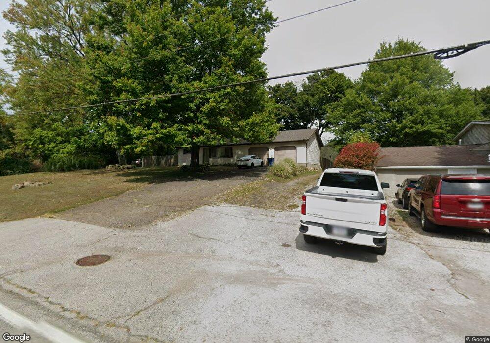
1783 Raber Rd Uniontown, OH 44685
Estimated Value: $201,000 - $266,000
3
Beds
1
Bath
1,008
Sq Ft
$223/Sq Ft
Est. Value
About This Home
This home is located at 1783 Raber Rd, Uniontown, OH 44685 and is currently estimated at $224,423, approximately $222 per square foot. 1783 Raber Rd is a home located in Summit County with nearby schools including Greenwood Elementary School, Green Intermediate Elementary School, and Green Primary School.
Ownership History
Date
Name
Owned For
Owner Type
Purchase Details
Closed on
Nov 7, 2012
Sold by
Mobley Lynda Lee
Bought by
Kenedy Samuel
Current Estimated Value
Purchase Details
Closed on
Mar 24, 2008
Sold by
Rogers Monte Jack
Bought by
Mobley Lynda Lee
Purchase Details
Closed on
Aug 19, 2007
Sold by
Rogers Monte Jack
Bought by
Rogers Monte Jack
Purchase Details
Closed on
May 5, 2004
Sold by
Shepherd Sandra K
Bought by
Rogers Monte Jack
Purchase Details
Closed on
Mar 12, 1998
Sold by
Rogers Monte Jack
Bought by
Shephard Sandra K
Create a Home Valuation Report for This Property
The Home Valuation Report is an in-depth analysis detailing your home's value as well as a comparison with similar homes in the area
Purchase History
| Date | Buyer | Sale Price | Title Company |
|---|---|---|---|
| Kenedy Samuel | $86,920 | None Available | |
| Mobley Lynda Lee | $91,760 | None Available | |
| Rogers Monte Jack | -- | None Available | |
| Rogers Monte Jack | $120,000 | -- | |
| Shephard Sandra K | $66,350 | -- |
Source: Public Records
Tax History
| Year | Tax Paid | Tax Assessment Tax Assessment Total Assessment is a certain percentage of the fair market value that is determined by local assessors to be the total taxable value of land and additions on the property. | Land | Improvement |
|---|---|---|---|---|
| 2025 | $4,152 | $57,205 | $20,192 | $37,013 |
| 2024 | $2,747 | $57,205 | $20,192 | $37,013 |
| 2023 | $4,152 | $57,205 | $20,192 | $37,013 |
| 2022 | $2,440 | $45,508 | $16,027 | $29,481 |
| 2021 | $2,291 | $45,508 | $16,027 | $29,481 |
| 2020 | $2,248 | $45,510 | $16,030 | $29,480 |
| 2019 | $1,598 | $29,840 | $13,330 | $16,510 |
| 2018 | $1,633 | $29,840 | $13,330 | $16,510 |
| 2017 | $1,671 | $29,840 | $13,330 | $16,510 |
| 2016 | $1,663 | $28,700 | $13,330 | $15,370 |
| 2015 | $1,671 | $28,700 | $13,330 | $15,370 |
| 2014 | $1,661 | $28,700 | $13,330 | $15,370 |
| 2013 | $1,770 | $30,430 | $13,330 | $17,100 |
Source: Public Records
Map
Nearby Homes
- 0 Raber Terrace
- 3544 Raber Terrace
- 2013 Dornoch Dr Unit 118
- 2033 Carlile Dr
- 3632 Kenwood Dr Unit 84
- 1909 E Turkeyfoot Lake Rd Unit 13
- 3495 Chadwick Dr
- 1670 Berna Rd
- 3397 Buckeye Trail
- 3560 Bushwillow Dr
- 3556 Bushwillow Dr
- 2229 E Park Dr
- 3531 Alder Ave
- 3549 Elmhurst Cir
- 3559 Alder Ave
- 3367 Ponderosa Trail
- 3567 Alder Ave
- 1236 Selena Grove
- 3491 Alder Ave
- 3495 Alder Ave
- 1791 Raber Rd
- 1773 Raber Rd
- 1763 Raber Rd
- 1751 Raber Rd
- 1743 Raber Rd
- 1820 Raber Rd
- 1823 Raber Rd
- 1731 Raber Rd
- 1843 Raber Rd Unit 1845
- 1725 Raber Rd
- 1722 Raber Rd
- 1850 Raber Rd
- 1853 Raber Rd
- 1711 Raber Rd
- 3507 Frawood Dr Unit 3511
- 3523 Frawood Dr
- 1770 Sawgrass Dr
- 1758 Sawgrass Dr
- 1744 Sawgrass Dr
- 1705 Raber Rd
Your Personal Tour Guide
Ask me questions while you tour the home.