
1784 New Franklin Rd Lagrange, GA 30240
Estimated payment $1,335/month
Highlights
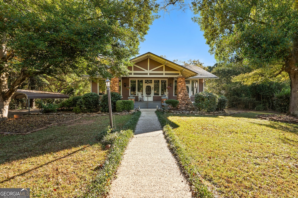
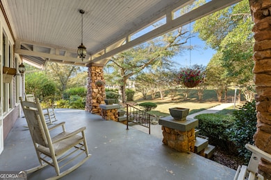
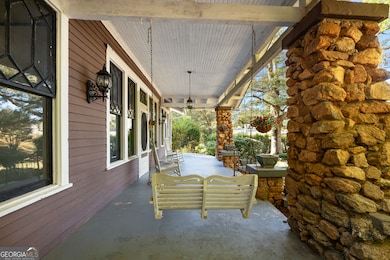
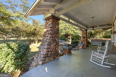
- Craftsman Architecture
- Dining Room Seats More Than Twelve
- Wood Flooring
- Hillcrest Elementary School Rated A-
- Fireplace in Primary Bedroom
- No HOA
About This Home
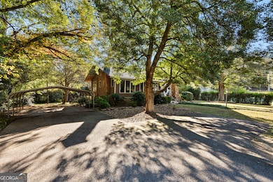
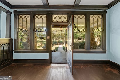
Step back in time with this 1930s Craftsman-style home, rumored to be one of the original Sears Kit Homes. Full of charm and character inside and out. This 3-bedroom, 1-bath property sits on a beautiful 1.5-acre lot, offering the perfect blend of history, space, and potential. From the moment you arrive, you'll appreciate the classic stone pillars, inviting front porch, and the architectural detail that defines this era. Inside, the home features coffered ceilings, four fireplaces, rich wood trim and built-ins that showcase the craftsmanship of its time. The spacious family room and dining room offer a warm and welcoming feel, while the screened-in back porch provides the perfect spot to enjoy quiet mornings or relaxing evenings overlooking the private yard. With 1.5 acres, there's ample room for gardens, outdoor entertaining, or future expansion. Whether you're looking to restore a true piece of history or bring your own creative vision to life, this property offers endless possibilities.
Home Details
Home Type
- Single Family
Est. Annual Taxes
- $1,815
Year Built
- Built in 1930
Lot Details
- 1.5 Acre Lot
Home Design
- Craftsman Architecture
- Bungalow
- Composition Roof
- Wood Siding
- Stone Siding
- Stone
Interior Spaces
- 1,702 Sq Ft Home
- 1-Story Property
- Bookcases
- Beamed Ceilings
- Family Room with Fireplace
- 4 Fireplaces
- Dining Room Seats More Than Twelve
- Formal Dining Room
- Screened Porch
- Wood Flooring
- Laundry Room
Kitchen
- Country Kitchen
- Oven or Range
Bedrooms and Bathrooms
- 3 Main Level Bedrooms
- Fireplace in Primary Bedroom
- 1 Full Bathroom
Parking
- 3 Parking Spaces
- Carport
- Parking Pad
Schools
- Franklin Forest Elementary School
- Gardner Newman Middle School
- Lagrange High School
Utilities
- Central Heating and Cooling System
- Septic Tank
- Cable TV Available
Community Details
- No Home Owners Association
Map
Home Values in the Area
Average Home Value in this Area
Tax History
| Year | Tax Paid | Tax Assessment Tax Assessment Total Assessment is a certain percentage of the fair market value that is determined by local assessors to be the total taxable value of land and additions on the property. | Land | Improvement |
|---|---|---|---|---|
| 2024 | $1,760 | $66,532 | $12,480 | $54,052 |
| 2023 | $1,782 | $67,336 | $12,480 | $54,856 |
| 2022 | $1,525 | $56,616 | $10,000 | $46,616 |
| 2021 | $1,173 | $40,892 | $10,000 | $30,892 |
| 2020 | $1,173 | $40,892 | $10,000 | $30,892 |
| 2019 | $802 | $28,580 | $4,000 | $24,580 |
| 2018 | $734 | $26,336 | $4,000 | $22,336 |
| 2017 | $734 | $26,336 | $4,000 | $22,336 |
| 2016 | $715 | $25,690 | $4,000 | $21,690 |
| 2015 | $716 | $25,690 | $4,000 | $21,690 |
| 2014 | $683 | $24,548 | $4,000 | $20,548 |
| 2013 | -- | $26,026 | $4,000 | $22,026 |
Property History
| Date | Event | Price | List to Sale | Price per Sq Ft |
|---|---|---|---|---|
| 10/31/2025 10/31/25 | Pending | -- | -- | -- |
| 10/21/2025 10/21/25 | For Sale | $225,000 | -- | $132 / Sq Ft |
Purchase History
| Date | Type | Sale Price | Title Company |
|---|---|---|---|
| Warranty Deed | $58,000 | -- | |
| Deed | -- | -- | |
| Deed | -- | -- |
Source: Georgia MLS
MLS Number: 10629041
APN: 062-1A-000-018
Disclaimer: Certain information contained herein is derived from information provided by parties other than Homes.com. All information provided is deemed reliable, but is not guaranteed to be accurate and should be independently verified.
![]() The data relating to real estate for sale on this web site comes in part from the Broker Reciprocity Program of Georgia MLS. Real estate listings held by brokerage firms other than Redfin are marked with the Broker Reciprocity logo and detailed information about them includes the name of the listing brokers. Information deemed reliable but not guaranteed. Copyright 2025 Georgia MLS. All rights reserved.
The data relating to real estate for sale on this web site comes in part from the Broker Reciprocity Program of Georgia MLS. Real estate listings held by brokerage firms other than Redfin are marked with the Broker Reciprocity logo and detailed information about them includes the name of the listing brokers. Information deemed reliable but not guaranteed. Copyright 2025 Georgia MLS. All rights reserved.
- 91 Richmond Dr
- 127 Oakmont Dr
- 209 River Oaks Dr
- LOT 106 River Oaks Dr
- 104 Hidden Branches Ln
- 109 Windridge
- 107 Windridge
- 118 Moss Creek Dr
- 117 Woodchase
- 100 Canterbury Dr
- 101 Sheffield Dr
- 127 Ashling Dr
- 104 Canterbury Dr
- 102 Canterbury Dr
- 105 Ridgeview Dr
- 89 Chase Rd
- 129 Sunny Point Cir
- 200 Crestwood Dr
- 1422 Mooty Bridge Rd
- 107 Dixie Creek Dr
