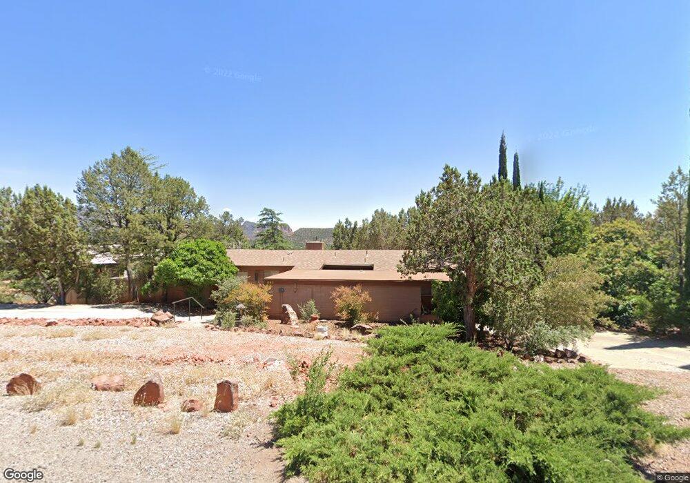
1785 Gun Fury Rd Sedona, AZ 86336
Estimated Value: $562,755 - $937,000
--
Bed
--
Bath
1,572
Sq Ft
$515/Sq Ft
Est. Value
About This Home
This home is located at 1785 Gun Fury Rd, Sedona, AZ 86336 and is currently estimated at $809,689, approximately $515 per square foot. 1785 Gun Fury Rd is a home located in Yavapai County with nearby schools including West Sedona Elementary School, Sedona Red Rock Junior/Senior High School, and Sedona Charter School.
Ownership History
Date
Name
Owned For
Owner Type
Purchase Details
Closed on
Apr 29, 2016
Sold by
Wing Philip C and Guistalino Nicholas A
Bought by
Win Irrevocable Trust and Guistalino Nicholas A
Current Estimated Value
Purchase Details
Closed on
Jul 28, 2013
Sold by
Wing Philip C
Bought by
Wing Philip C
Purchase Details
Closed on
May 3, 2013
Sold by
Wing Philip C and Haynie Patrick C
Bought by
Wing Philip C
Purchase Details
Closed on
Aug 18, 2011
Sold by
Wing Family Living Trust and Wing Philip C
Bought by
Wh Trust and Wing Philip C
Purchase Details
Closed on
Mar 16, 1999
Sold by
Wing Malin H and Wing Beatrice Beschta
Bought by
Wing Malin H and Wing Beatrice Beschta
Home Financials for this Owner
Home Financials are based on the most recent Mortgage that was taken out on this home.
Original Mortgage
$45,000
Interest Rate
6.36%
Purchase Details
Closed on
Mar 15, 1999
Sold by
Wing Malin H and Wing Beatrice Beschta
Bought by
Wing Malin H and Wing Beatrice Beschta
Home Financials for this Owner
Home Financials are based on the most recent Mortgage that was taken out on this home.
Original Mortgage
$45,000
Interest Rate
6.36%
Create a Home Valuation Report for This Property
The Home Valuation Report is an in-depth analysis detailing your home's value as well as a comparison with similar homes in the area
Home Values in the Area
Average Home Value in this Area
Purchase History
| Date | Buyer | Sale Price | Title Company |
|---|---|---|---|
| Win Irrevocable Trust | -- | None Available | |
| Wing Philip C | -- | None Available | |
| Wing Philip C | -- | None Available | |
| Wh Trust | -- | None Available | |
| Wing Malin H | -- | Yavapai Coconino Title Agenc | |
| Wing Malin H | -- | Yavapai Coconino Title Agenc |
Source: Public Records
Mortgage History
| Date | Status | Borrower | Loan Amount |
|---|---|---|---|
| Closed | Wing Malin H | $45,000 |
Source: Public Records
Tax History Compared to Growth
Tax History
| Year | Tax Paid | Tax Assessment Tax Assessment Total Assessment is a certain percentage of the fair market value that is determined by local assessors to be the total taxable value of land and additions on the property. | Land | Improvement |
|---|---|---|---|---|
| 2026 | $2,376 | $51,405 | -- | -- |
| 2024 | $2,368 | $56,050 | -- | -- |
| 2023 | $2,368 | $38,951 | $12,685 | $26,266 |
| 2022 | $2,264 | $31,465 | $10,562 | $20,903 |
| 2021 | $2,324 | $29,779 | $9,091 | $20,688 |
| 2020 | $2,323 | $0 | $0 | $0 |
| 2019 | $2,305 | $0 | $0 | $0 |
| 2018 | $2,192 | $0 | $0 | $0 |
| 2017 | $2,140 | $0 | $0 | $0 |
| 2016 | $2,099 | $0 | $0 | $0 |
| 2015 | -- | $0 | $0 | $0 |
| 2014 | -- | $0 | $0 | $0 |
Source: Public Records
Map
Nearby Homes
- 460 Coffee Pot Dr
- 55 Stations Dr W
- 310 Mountain Shadows Dr Unit 89
- 747 Mountain Shadows Dr
- 145 Grounds Dr
- 160 Budd Way
- 260 Coffee Pot Dr Unit 17
- 260 Coffee Pot Dr Unit 6
- 260 Coffee Pot Dr Unit 20
- 25 Santa Barbara Dr
- 2190 Sanborn Dr
- 280 Goodrow Ln
- 30 Schimberg Rd
- 2200 Buckboard Rd
- 1445 Cline Rd
- 1670 W State Route 89a
- 1483 Vista Montana Rd
- 25 Edgewood Cir
- 307 Calle Linda Unit 61
- 240 Goodrow Ln
- 1805 Gun Fury Rd
- 185 Last Wagon Dr
- 210 Last Wagon Dr
- 1780 Gun Fury Rd
- 190 Last Wagon Dr
- 1800 Gun Fury Rd
- 165 Last Wagon Dr
- 30 Zane Grey Cir Unit 1
- 230 Last Wagon Dr
- 1825 Gun Fury Rd
- 1820 Gun Fury Rd
- 150 Last Wagon Dr
- 55 Mogollon Dr
- 255 Last Wagon Dr
- 65 Mogollon Dr
- 250 Last Wagon Dr
- 190 Copper Canyon Dr
- 86 Last Wagon Dr