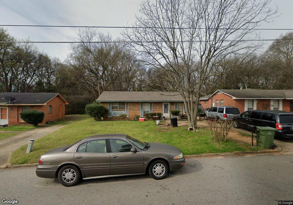
179 Briarbrook Dr Montgomery, AL 36110
North Montgomery NeighborhoodEstimated Value: $51,000 - $62,000
--
Bed
--
Bath
1,025
Sq Ft
$55/Sq Ft
Est. Value
About This Home
This home is located at 179 Briarbrook Dr, Montgomery, AL 36110 and is currently estimated at $56,397, approximately $55 per square foot. 179 Briarbrook Dr is a home located in Montgomery County with nearby schools including Chisholm Elementary School, Capitol Heights Middle School, and Dr. Percy L. Julian High School.
Ownership History
Date
Name
Owned For
Owner Type
Purchase Details
Closed on
Mar 25, 2005
Sold by
Washington Diane Mcdaniel
Bought by
Robinson Melvin and Robinson Ordean
Current Estimated Value
Purchase Details
Closed on
Mar 24, 2005
Sold by
Ross Betty C
Bought by
Robinson Melvin and Robinson Ordean
Purchase Details
Closed on
Mar 23, 2005
Sold by
Gray Daniel C
Bought by
Robinson Melvin and Robinson Ordean
Purchase Details
Closed on
Aug 20, 1998
Sold by
Elizabeth Peterson
Bought by
Gray Daniel C and Ross Betty C
Create a Home Valuation Report for This Property
The Home Valuation Report is an in-depth analysis detailing your home's value as well as a comparison with similar homes in the area
Home Values in the Area
Average Home Value in this Area
Purchase History
| Date | Buyer | Sale Price | Title Company |
|---|---|---|---|
| Robinson Melvin | -- | -- | |
| Robinson Melvin | -- | -- | |
| Robinson Melvin | -- | -- | |
| Robinson Melvin | -- | -- | |
| Gray Daniel C | -- | -- |
Source: Public Records
Tax History Compared to Growth
Tax History
| Year | Tax Paid | Tax Assessment Tax Assessment Total Assessment is a certain percentage of the fair market value that is determined by local assessors to be the total taxable value of land and additions on the property. | Land | Improvement |
|---|---|---|---|---|
| 2025 | $592 | $12,280 | $1,200 | $11,080 |
| 2024 | $554 | $11,320 | $1,200 | $10,120 |
| 2023 | $554 | $9,780 | $1,200 | $8,580 |
| 2022 | $357 | $9,780 | $1,200 | $8,580 |
| 2021 | $304 | $8,320 | $1,200 | $7,120 |
| 2020 | $293 | $8,020 | $1,200 | $6,820 |
| 2019 | $293 | $8,020 | $1,200 | $6,820 |
| 2018 | $272 | $7,440 | $0 | $0 |
| 2017 | $273 | $7,480 | $1,200 | $6,280 |
| 2014 | $311 | $8,520 | $1,200 | $7,320 |
| 2013 | -- | $9,120 | $1,200 | $7,920 |
Source: Public Records
Map
Nearby Homes
- 142 W Michigan Ave
- 141 W Michigan Ave
- 59 Michigan Ave
- 55 Michigan Ave
- 412 Edward St
- 39 Cox Ln
- 35 Cox Ln
- 2035 Jackson Ferry Rd
- 428 Conrad St
- 2925 Lower Wetumpka Rd
- 544 Conrad St
- 548 Conrad St
- 114 Rotary St
- 12 Pine St
- 15 Broadway St
- 5 Johnson Ave
- 101 Brockway Dr
- 7 Johnson Ave
- 311 3rd St
- 1641 N Yarbrough Ct
- 183 Briarbrook Dr
- 175 Briarbrook Dr
- 201 Briarbrook Dr
- 171 Briarbrook Dr
- 400 Castlebrook Dr
- 205 Briarbrook Dr
- 167 Briarbrook Dr
- 401 Castlebrook Dr
- 166 Briarbrook Dr
- 209 Briarbrook Dr
- 204 Briarbrook Dr
- 404 Castlebrook Dr
- 163 Briarbrook Dr
- 162 Briarbrook Dr
- 409 Castlebrook Dr
- 213 Briarbrook Dr
- 400 Briarbrook Ct
- 159 Briarbrook Dr
- 408 Castlebrook Dr
- 417 Castlebrook Dr