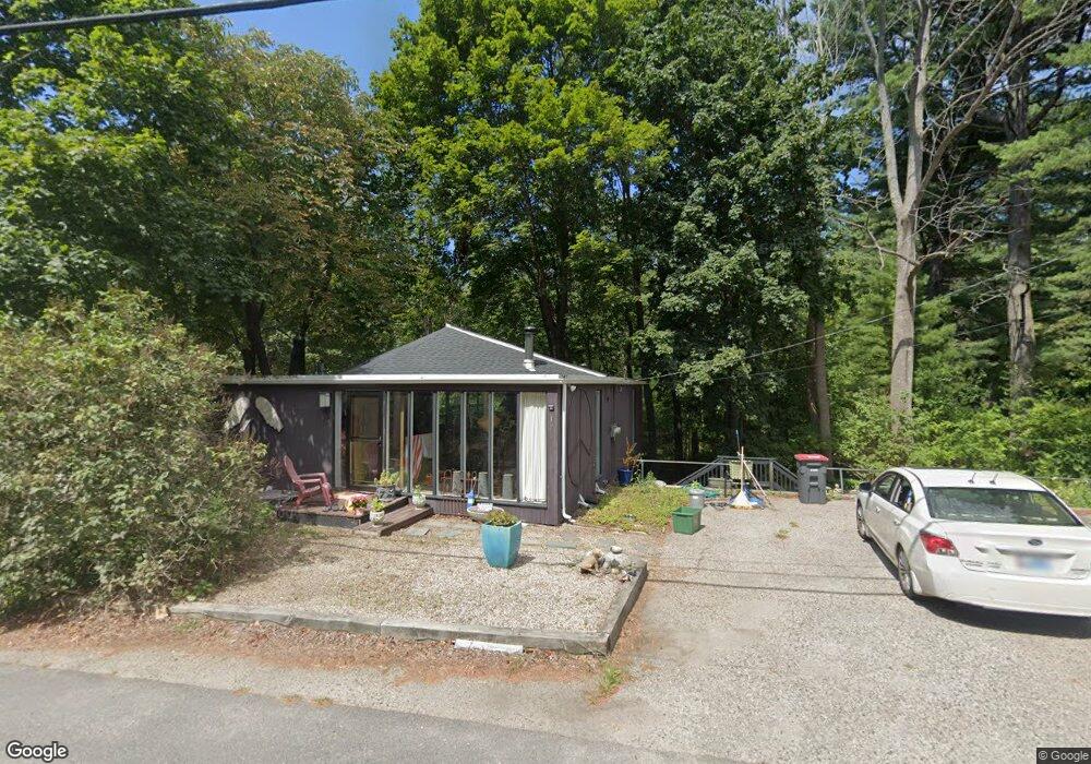
179 Pepperrell Rd Kittery Point, ME 03905
Kittery Point NeighborhoodEstimated Value: $408,591 - $590,000
1
Bed
1
Bath
960
Sq Ft
$522/Sq Ft
Est. Value
About This Home
This home is located at 179 Pepperrell Rd, Kittery Point, ME 03905 and is currently estimated at $501,148, approximately $522 per square foot. 179 Pepperrell Rd is a home with nearby schools including Horace Mitchell Primary School, Shapleigh School, and Robert W Traip Academy.
Ownership History
Date
Name
Owned For
Owner Type
Purchase Details
Closed on
May 31, 2005
Sold by
Kelly James F and Bushold Karen R
Bought by
Fuller Joann
Current Estimated Value
Home Financials for this Owner
Home Financials are based on the most recent Mortgage that was taken out on this home.
Original Mortgage
$50,000
Outstanding Balance
$26,405
Interest Rate
5.94%
Mortgage Type
Purchase Money Mortgage
Estimated Equity
$474,743
Create a Home Valuation Report for This Property
The Home Valuation Report is an in-depth analysis detailing your home's value as well as a comparison with similar homes in the area
Home Values in the Area
Average Home Value in this Area
Purchase History
| Date | Buyer | Sale Price | Title Company |
|---|---|---|---|
| Fuller Joann | -- | -- |
Source: Public Records
Mortgage History
| Date | Status | Borrower | Loan Amount |
|---|---|---|---|
| Open | Fuller Joann | $50,000 |
Source: Public Records
Tax History
| Year | Tax Paid | Tax Assessment Tax Assessment Total Assessment is a certain percentage of the fair market value that is determined by local assessors to be the total taxable value of land and additions on the property. | Land | Improvement |
|---|---|---|---|---|
| 2024 | $3,979 | $280,200 | $148,200 | $132,000 |
| 2023 | $3,814 | $280,200 | $148,200 | $132,000 |
| 2022 | $3,777 | $280,200 | $148,200 | $132,000 |
| 2021 | $3,643 | $280,200 | $148,200 | $132,000 |
| 2020 | $3,615 | $280,200 | $148,200 | $132,000 |
| 2019 | $2,765 | $158,900 | $54,400 | $104,500 |
| 2018 | $2,450 | $158,900 | $54,400 | $104,500 |
| 2017 | $2,622 | $158,900 | $54,400 | $104,500 |
| 2016 | $2,396 | $149,300 | $54,400 | $94,900 |
| 2015 | $2,340 | $149,300 | $54,400 | $94,900 |
| 2014 | $2,317 | $149,300 | $54,400 | $94,900 |
| 2013 | $2,272 | $149,300 | $54,400 | $94,900 |
Source: Public Records
Map
Nearby Homes
- 52 Goodwin Rd
- 24 Seabreeze Ln
- 25 Bartlett Rd
- 2 Washburn Farm Ln Unit 1
- 7 Washburn Farm Ln Unit 9
- 18 Washburn Farm Ln Unit 4
- 12 Gillis Dr Unit 3
- 12 Washburn Farm Ln Unit 3
- 8 Spruce Point Rd
- 18 Mainmast Cir
- 3 Izzy Ln
- 4 Trefethen Ave
- 13 Washburn Farm Ln Unit 7
- 8 Grover Ave
- 50 Lewis Rd
- 30 Drake Ln
- 10 Blueberry Ln
- 75 Marina Heights Rd
- 100 Shepard's Cove Rd Unit H305
- 100 Shepard's Cove Rd Unit G107
- 177 Pepperrell Rd
- 3 Tenney Hill Rd
- 175 Pepperrell Rd
- 182 Pepperrell Rd
- 17 Keene
- 1 Keen Ave
- 2 Tenney Hill Rd
- 172 Pepperrell Rd
- 000 Keen Ave
- 4 Keen Ave
- 4A Chauncey Creek Rd
- 5 Chauncey Creek Rd
- 4 Chauncey Creek Rd
- 2 Chauncey Creek Rd
- 5 Tenney Hill Rd
- 169 Pepperrell Rd
- 167 Pepperrell Way(route 103)
- 7 Chauncey Creek Rd
- 4 Tenney Hill Rd
- 167 Pepperrell Rd
Your Personal Tour Guide
Ask me questions while you tour the home.