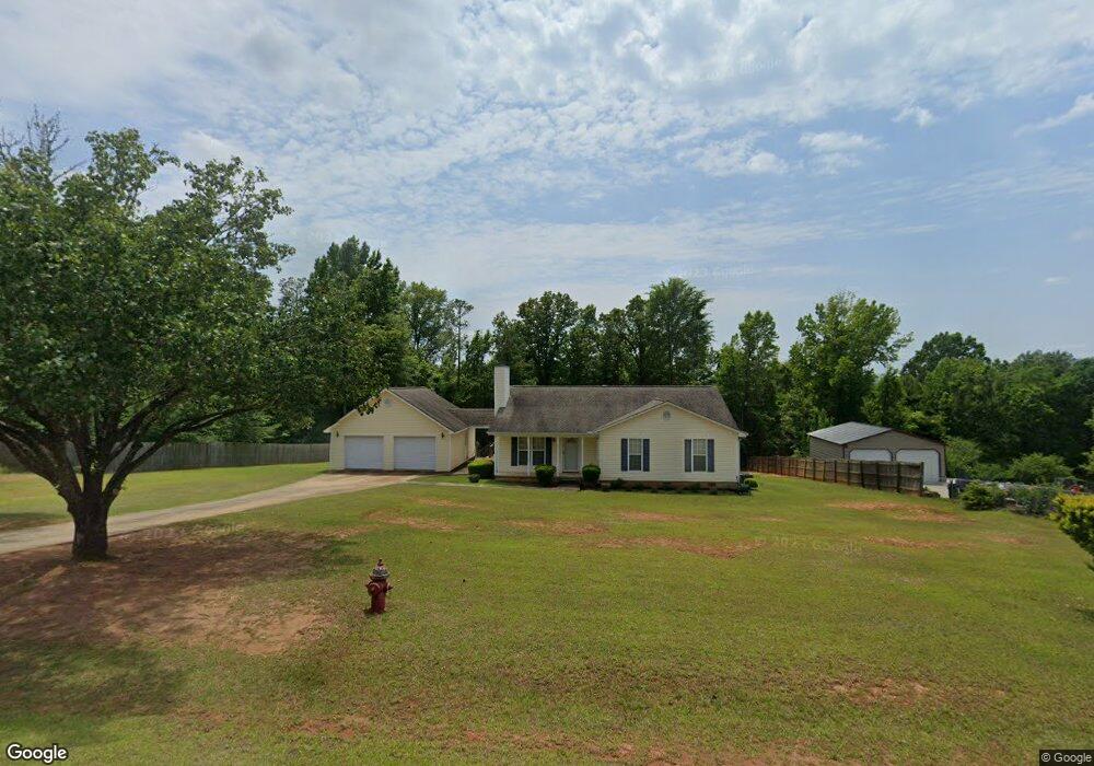
179 Wheehaw Rd Macon, GA 31211
Estimated Value: $190,000 - $220,000
--
Bed
2
Baths
1,728
Sq Ft
$116/Sq Ft
Est. Value
About This Home
This home is located at 179 Wheehaw Rd, Macon, GA 31211 and is currently estimated at $200,337, approximately $115 per square foot. 179 Wheehaw Rd is a home located in Jones County with nearby schools including Dames Ferry Elementary School, Clifton Ridge Middle School, and Jones County High School.
Ownership History
Date
Name
Owned For
Owner Type
Purchase Details
Closed on
Jul 6, 2001
Sold by
Nations Bank Mortgage Crop
Bought by
Anderson Kenneth L and Anderson Kesha
Current Estimated Value
Purchase Details
Closed on
May 1, 2001
Sold by
Nations Banc Mortgage Corp
Bought by
Federal Home Loan Mortgage
Create a Home Valuation Report for This Property
The Home Valuation Report is an in-depth analysis detailing your home's value as well as a comparison with similar homes in the area
Home Values in the Area
Average Home Value in this Area
Purchase History
| Date | Buyer | Sale Price | Title Company |
|---|---|---|---|
| Anderson Kenneth L | -- | -- | |
| Federal Home Loan Mortgage | -- | -- | |
| Nations Bank Mortgage Crop | $85,400 | -- |
Source: Public Records
Tax History Compared to Growth
Tax History
| Year | Tax Paid | Tax Assessment Tax Assessment Total Assessment is a certain percentage of the fair market value that is determined by local assessors to be the total taxable value of land and additions on the property. | Land | Improvement |
|---|---|---|---|---|
| 2024 | $1,881 | $56,650 | $5,000 | $51,650 |
| 2023 | $1,636 | $49,250 | $5,000 | $44,250 |
| 2022 | $1,477 | $44,810 | $4,650 | $40,160 |
| 2021 | $1,478 | $44,810 | $4,650 | $40,160 |
| 2020 | $1,479 | $44,810 | $4,650 | $40,160 |
| 2019 | $1,479 | $44,810 | $4,650 | $40,160 |
| 2018 | $1,479 | $44,810 | $4,650 | $40,160 |
| 2017 | $1,479 | $44,810 | $4,650 | $40,160 |
| 2016 | $1,479 | $44,810 | $4,650 | $40,160 |
| 2015 | $1,396 | $44,810 | $4,650 | $40,160 |
| 2014 | $1,291 | $44,810 | $4,650 | $40,160 |
Source: Public Records
Map
Nearby Homes
- V L Silver Lake Ct Unit LotWP001
- 246 Joycliff Cir
- 0 Silver Lake Ct Unit 10558444
- 2771 Old Gray Hwy
- 3608 Joycliff Rd
- 194 Baker Rd
- 190 Chapman Ridge Lot 22 Rd
- 192 Chapman Ridge Rd Unit LOT 21
- 190 Chapman Ridge Lot #22 Rd
- 190 Chapman Ridge Rd Unit LOT 22
- 227 Dusty Ln
- 168 Chapman Ridge Rd
- 168 Chapman Ridge Rd Unit 28
- 225 Olivia Cir
- Oakville Plan at Chapman Ridge
- Westwind Plan at Chapman Ridge
- Yarborough Plan at Chapman Ridge
- Fairfield Plan at Chapman Ridge
- 120 Chapman Ridge Lot #40 Rd
- 3446 Kingsview Cir
- 183 Wheehaw Rd
- 173 Wheehaw Rd
- 178 Wheehaw Rd
- 167 Wheehaw Rd
- 184 Wheehaw Rd
- 170 Wheehaw Rd
- 161 Wheehaw Rd
- 160 Wheehaw Rd
- 153 Wheehaw Rd
- 800 Princess Anne Dr
- 154 Wheehaw Rd
- 173 Princess Anne Dr
- 145 Wheehaw Rd
- 0 Princess Anne Dr Unit 3 8183487
- 0 Princess Anne Dr Unit 2 8183446
- 146 Wheehaw Rd
- 113 Regency Ct
- 188 Princess Anne Dr
- 159 Princess Anne Dr
- 159 Princess Anne Dr Unit 10