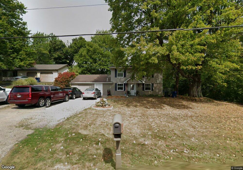
1791 Raber Rd Uniontown, OH 44685
Estimated Value: $276,000 - $292,000
3
Beds
1
Bath
1,972
Sq Ft
$144/Sq Ft
Est. Value
About This Home
This home is located at 1791 Raber Rd, Uniontown, OH 44685 and is currently estimated at $284,414, approximately $144 per square foot. 1791 Raber Rd is a home located in Summit County with nearby schools including Greenwood Elementary School, Green Intermediate Elementary School, and Green Primary School.
Ownership History
Date
Name
Owned For
Owner Type
Purchase Details
Closed on
Apr 8, 2021
Sold by
Dan Hickman Properties Llc
Bought by
Leger Andrew and Leger Kayli Renee
Current Estimated Value
Home Financials for this Owner
Home Financials are based on the most recent Mortgage that was taken out on this home.
Original Mortgage
$184,140
Outstanding Balance
$165,988
Interest Rate
2.9%
Mortgage Type
VA
Estimated Equity
$118,426
Purchase Details
Closed on
Apr 22, 2011
Sold by
Household Realty Corporation
Bought by
Dan Hickman Properties Llc
Purchase Details
Closed on
Nov 9, 2010
Sold by
Hood Wilkie and Hood Joyce
Bought by
Household Realty Corporation
Create a Home Valuation Report for This Property
The Home Valuation Report is an in-depth analysis detailing your home's value as well as a comparison with similar homes in the area
Purchase History
| Date | Buyer | Sale Price | Title Company |
|---|---|---|---|
| Leger Andrew | $184,000 | Buckeye Reserve Title | |
| Dan Hickman Properties Llc | $44,900 | Omega Title Agency Llc | |
| Household Realty Corporation | $72,000 | None Available |
Source: Public Records
Mortgage History
| Date | Status | Borrower | Loan Amount |
|---|---|---|---|
| Open | Leger Andrew | $184,140 |
Source: Public Records
Tax History
| Year | Tax Paid | Tax Assessment Tax Assessment Total Assessment is a certain percentage of the fair market value that is determined by local assessors to be the total taxable value of land and additions on the property. | Land | Improvement |
|---|---|---|---|---|
| 2025 | $3,630 | $72,272 | $13,794 | $58,478 |
| 2024 | $3,630 | $72,272 | $13,794 | $58,478 |
| 2023 | $3,630 | $72,272 | $13,794 | $58,478 |
| 2022 | $3,263 | $58,079 | $10,948 | $47,131 |
| 2021 | $2,892 | $56,459 | $10,948 | $45,511 |
| 2020 | $2,839 | $56,460 | $10,950 | $45,510 |
| 2019 | $2,149 | $39,760 | $11,510 | $28,250 |
| 2018 | $2,196 | $39,760 | $11,510 | $28,250 |
| 2017 | $2,226 | $39,760 | $11,510 | $28,250 |
| 2016 | $2,215 | $37,830 | $11,510 | $26,320 |
| 2015 | $2,226 | $37,830 | $11,510 | $26,320 |
| 2014 | $2,212 | $37,830 | $11,510 | $26,320 |
| 2013 | $2,228 | $37,830 | $11,510 | $26,320 |
Source: Public Records
Map
Nearby Homes
- 0 Raber Terrace
- 3544 Raber Terrace
- 2013 Dornoch Dr Unit 118
- 2033 Carlile Dr
- 3632 Kenwood Dr Unit 84
- 1909 E Turkeyfoot Lake Rd Unit 13
- 3495 Chadwick Dr
- 1670 Berna Rd
- 2229 E Park Dr
- 3397 Buckeye Trail
- 3560 Bushwillow Dr
- 3556 Bushwillow Dr
- 3549 Elmhurst Cir
- 3531 Alder Ave
- 3559 Alder Ave
- 3367 Ponderosa Trail
- 3567 Alder Ave
- 1236 Selena Grove
- 1457 5th Ave
- 3491 Alder Ave
- 1783 Raber Rd
- 1773 Raber Rd
- 1763 Raber Rd
- 1820 Raber Rd
- 1751 Raber Rd
- 1823 Raber Rd
- 1743 Raber Rd
- 1843 Raber Rd Unit 1845
- 1731 Raber Rd
- 1850 Raber Rd
- 1853 Raber Rd
- 1725 Raber Rd
- 1722 Raber Rd
- 3578 Saddleboro Dr
- 3568 Saddleboro Dr
- 1711 Raber Rd
- 1876 Raber Rd
- 3560 Saddleboro Dr
- 1770 Sawgrass Dr
- 3507 Frawood Dr Unit 3511
Your Personal Tour Guide
Ask me questions while you tour the home.