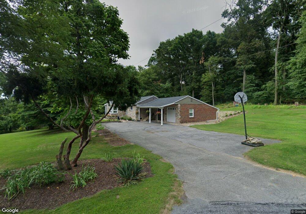
1796 Stonesthrow Rd Bethlehem, PA 18015
Upper Saucon Township NeighborhoodEstimated Value: $332,000 - $397,000
2
Beds
1
Bath
1,142
Sq Ft
$325/Sq Ft
Est. Value
About This Home
This home is located at 1796 Stonesthrow Rd, Bethlehem, PA 18015 and is currently estimated at $370,859, approximately $324 per square foot. 1796 Stonesthrow Rd is a home located in Lehigh County with nearby schools including Southern Lehigh High School, Arts Academy Charter Middle School, and Lehigh Valley Charter High School for the Arts.
Ownership History
Date
Name
Owned For
Owner Type
Purchase Details
Closed on
Apr 26, 2016
Sold by
Mitchell James H
Bought by
Mitchell James H and Mitchell Dorism
Current Estimated Value
Purchase Details
Closed on
Feb 15, 2011
Sold by
Homesales Inc
Bought by
Mitchell James H
Purchase Details
Closed on
Jan 31, 2011
Sold by
Rossi Sheriff Ronald W and Zimmermann Woodie
Bought by
Homesales Inc
Purchase Details
Closed on
Nov 30, 2007
Sold by
Smith Richard D
Bought by
Zimmermann Woodie
Home Financials for this Owner
Home Financials are based on the most recent Mortgage that was taken out on this home.
Original Mortgage
$226,100
Interest Rate
6.3%
Mortgage Type
New Conventional
Purchase Details
Closed on
Apr 8, 1992
Sold by
Smith Richard D and Smith Susan N
Bought by
Smith Richard D
Purchase Details
Closed on
Mar 30, 1984
Bought by
Smith Richard D and Smith Susan N
Create a Home Valuation Report for This Property
The Home Valuation Report is an in-depth analysis detailing your home's value as well as a comparison with similar homes in the area
Home Values in the Area
Average Home Value in this Area
Purchase History
| Date | Buyer | Sale Price | Title Company |
|---|---|---|---|
| Mitchell James H | -- | Attorney | |
| Mitchell James H | $134,880 | -- | |
| Homesales Inc | -- | -- | |
| Zimmermann Woodie | $238,000 | -- | |
| Smith Richard D | -- | -- | |
| Smith Richard D | $76,800 | -- |
Source: Public Records
Mortgage History
| Date | Status | Borrower | Loan Amount |
|---|---|---|---|
| Previous Owner | Zimmermann Woodie | $226,100 |
Source: Public Records
Tax History Compared to Growth
Tax History
| Year | Tax Paid | Tax Assessment Tax Assessment Total Assessment is a certain percentage of the fair market value that is determined by local assessors to be the total taxable value of land and additions on the property. | Land | Improvement |
|---|---|---|---|---|
| 2025 | $4,514 | $199,000 | $90,200 | $108,800 |
| 2024 | $4,514 | $199,000 | $90,200 | $108,800 |
| 2023 | $4,459 | $199,000 | $90,200 | $108,800 |
| 2022 | $4,394 | $199,000 | $108,800 | $90,200 |
| 2021 | $4,296 | $199,000 | $90,200 | $108,800 |
| 2020 | $4,213 | $199,000 | $90,200 | $108,800 |
| 2019 | $4,145 | $199,000 | $90,200 | $108,800 |
| 2018 | $4,145 | $199,000 | $90,200 | $108,800 |
| 2017 | $4,105 | $199,000 | $90,200 | $108,800 |
| 2016 | -- | $199,000 | $90,200 | $108,800 |
| 2015 | -- | $199,000 | $90,200 | $108,800 |
| 2014 | -- | $199,000 | $90,200 | $108,800 |
Source: Public Records
Map
Nearby Homes
- 0 Strauss Ln Unit 1 759755
- 3689 Fire Ln
- 2212 S Melrose Ave
- 4252 Stonebridge Dr
- 4244 Stonebridge Dr
- 4260 Stonebridge Dr
- 4268 Stonebridge Dr
- 2209 S Melrose Ln
- 4228 Stonebridge Dr
- 4276 Stonebridge Dr
- 4220 Stonebridge Dr
- 4287 Stonebridge Dr
- 4212 Stonebridge Dr
- 4299 Stonebridge Dr
- 4303 Stonebridge Dr
- 4319 Stonebridge Dr
- 1857 Stonesthrow Rd
- 1754 Stonesthrow Rd
- 1787 Stonesthrow Rd
- 1749 Stonesthrow Rd
- 1728 Stonesthrow Rd
- 1930 Stonesthrow Rd
- 1940 Stonesthrow Rd
- 1939 Stonesthrow Rd
- 1712 Stonesthrow Rd
- 1975 Stonesthrow Rd
- 1686 Stonesthrow Rd
- 1285 Stonesthrow Rd
- 2091 Stonesthrow Rd
- 2080 Stonesthrow Rd
- 2050 Black River Rd
- 1920 Black River Rd
- 2016 Stonesthrow Rd
- 2040 Black River Rd
- 1667 Stonesthrow Rd
- 2001 Stonesthrow Rd