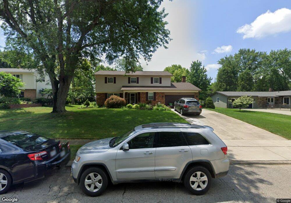
1799 Kempton Dr Columbus, OH 43220
Estimated Value: $565,000 - $732,000
4
Beds
3
Baths
2,368
Sq Ft
$271/Sq Ft
Est. Value
About This Home
This home is located at 1799 Kempton Dr, Columbus, OH 43220 and is currently estimated at $642,273, approximately $271 per square foot. 1799 Kempton Dr is a home located in Franklin County with nearby schools including Greensview Elementary School, Hastings Middle School, and Upper Arlington High School.
Ownership History
Date
Name
Owned For
Owner Type
Purchase Details
Closed on
Aug 2, 1996
Sold by
Taylor Michael B
Bought by
Neff Brad F and Neff Margaret G
Current Estimated Value
Home Financials for this Owner
Home Financials are based on the most recent Mortgage that was taken out on this home.
Original Mortgage
$140,000
Outstanding Balance
$6,370
Interest Rate
7%
Mortgage Type
New Conventional
Estimated Equity
$635,903
Purchase Details
Closed on
Sep 10, 1992
Create a Home Valuation Report for This Property
The Home Valuation Report is an in-depth analysis detailing your home's value as well as a comparison with similar homes in the area
Home Values in the Area
Average Home Value in this Area
Purchase History
We collect this data history from publicly available records. To have your information removed, we recommend requesting removal directly through your county’s website.
| Date | Buyer | Sale Price | Title Company |
|---|---|---|---|
| Neff Brad F | $175,000 | -- | |
| -- | $175,000 | -- |
Source: Public Records
Mortgage History
We collect this data history from publicly available records. To have your information removed, we recommend requesting removal directly through your county’s website.
| Date | Status | Borrower | Loan Amount |
|---|---|---|---|
| Open | Neff Brad F | $140,000 |
Source: Public Records
Tax History
| Year | Tax Paid | Tax Assessment Tax Assessment Total Assessment is a certain percentage of the fair market value that is determined by local assessors to be the total taxable value of land and additions on the property. | Land | Improvement |
|---|---|---|---|---|
| 2025 | $9,971 | $172,240 | $74,100 | $98,140 |
| 2024 | $9,971 | $172,240 | $74,100 | $98,140 |
| 2023 | $9,848 | $172,240 | $74,100 | $98,140 |
| 2022 | $8,714 | $124,710 | $50,090 | $74,620 |
| 2021 | $7,714 | $124,710 | $50,090 | $74,620 |
| 2020 | $7,646 | $124,710 | $50,090 | $74,620 |
| 2019 | $7,133 | $102,870 | $50,090 | $52,780 |
| 2018 | $6,645 | $102,870 | $50,090 | $52,780 |
| 2017 | $7,079 | $102,870 | $50,090 | $52,780 |
| 2016 | $6,203 | $93,810 | $31,890 | $61,920 |
| 2015 | $6,197 | $93,810 | $31,890 | $61,920 |
| 2014 | $6,204 | $93,810 | $31,890 | $61,920 |
| 2013 | $2,962 | $85,260 | $28,980 | $56,280 |
Source: Public Records
Map
Nearby Homes
- 1727 Arlingate Dr N Unit 1727
- 1955 Rosebery Dr
- 1915 Brandywine Dr
- 1512 Lafayette Dr Unit B
- 4423 Woodbridge Rd
- 1474 Lafayette Dr Unit B
- 1484 Lafayette Dr Unit A
- 4528 Carriage Hill Ln Unit 4528
- 2080 Mackenzie Dr Unit 12
- 4818 Larwell Dr
- 4781 Coach Rd
- 1945 Willoway Cir N Unit 1945
- 1920 Mccoy Rd
- 1363 Castleton Rd N
- 4605 Lanercost Way
- 4641 Orwell Dr Unit 4641
- 4651 Orwell Dr Unit 4651
- 2248 Sandover Rd
- 4120 Lyon Dr
- 4085 Lyon Dr
- 1810 Ivanhoe Ct
- 1820 Ivanhoe Ct
- 1790 Ivanhoe Ct
- 1811 Kempton Dr
- 1830 Ivanhoe Ct
- 1787 Kempton Dr
- 1780 Ivanhoe Ct
- 1823 Kempton Dr
- 1811 Ivanhoe Ct
- 1821 Ivanhoe Ct
- 1795 Ivanhoe Ct
- 1775 Kempton Dr
- 1770 Ivanhoe Ct
- 1835 Kempton Dr
- 1831 Ivanhoe Ct
- 1785 Ivanhoe Ct
- 4585 Shires Ct
- 4520 Cassill St
- 1849 Kempton Dr
- 4590 Elan Ct
Your Personal Tour Guide
Ask me questions while you tour the home.